Grade 1 Arable Land, A17 Highway, Sutterton, off Marsh Road
Business rates & charges may apply

- SIZE
Ask agent
- SECTOR
Farm land for sale
Description
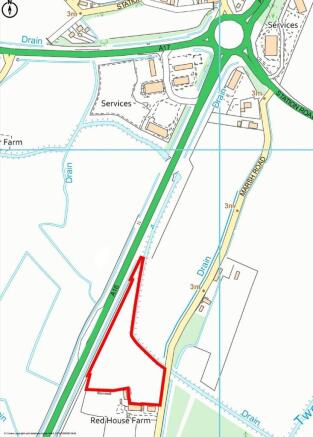
An opportunity to acquire 1.686 Hectares (4.16 Acres) or thereabouts of Grade I Arable land situate to the East of the A17 Highway, Sutterton in a singular enclosure which is suitable for a range of uses subject to obtaining the necessary consents. The land is accessed directly off Marsh Road, Sutterton. Further information regarding the access can be obtained from the Selling Agents.
LOCATION:
The land is situate approximately 1.8 miles southeast of Sutterton which provides a range of local scale amenities and services, and the land lies approximately 7.4 miles south of Boston. Boston provides a range of more extensive facilities and services. The land can be located using the following What3Word location: ///tokens.deriving.hometown
ACCESS:
The land is accessed directly off Marsh Road, Sutterton.
METHOD OF SALE:
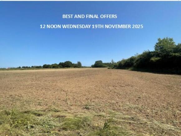
The land is offered for sale by Private Treaty. The Vendor reserves the right to conclude the sale by ´Best and Final´ offers or by private auction. The land is offered for sale freehold with vacant possession. Interested parties who may wish to discuss any aspect of this should contact the Vendor´s Agent - Richard Start ( ) or Alice Peach ( ) on Option 4.
TENURE:
The land is offered for sale freehold with vacant possession.
RIGHTS OF WAY:
The land is sold subject to and with the benefit of all rights of way, public or private easements and wayleaves whether stated in these Particulars or not. However, interested parties are advised to make their own enquiries.
VIEWING:
Viewing is possible during daylight hours with a set of these sales particulars to hand. Any parties viewing the land do so entirely at their own risk and are responsible for ensuring their own safety.
SPORTING RIGHTS:
The Sporting Rights are included in the sale as far as owned by the Seller.
MINERALS AND TIMBER:
The mineral rights are included in the sale as far as owned by the Seller.
OUTGOINGS:
Drainage rates are payable to the relevant Internal Drainage Board.
EARLY ENTRY:
Early entry may be granted to the buyer after exchange of contracts and payment of a double deposit.
CONTRACTS AND QUOTAS:
There are no contracts or quotas included within the sale of the land.
BACK CROPPING:
The land has historically been used for commercial agricultural purposes.
SOIL TYPE:
The land is classified as Grade I agricultural land on the former Ministry of Agriculture, Fisheries & Food land classification map of England and Wales. The actual soil type is further described by the Soil Survey of England and Wales as being of the Tanvats Association of Soils which is characterised as being "Deep stoneless fine and coarse silty and clayey soils with groundwater levels controlled by ditches and pumps. Flat land."
WAYLEAVES, RIGHTS OF WAY AND EASEMENTS
The Land will be sold subject to and offered with the benefit of all existing rights, including rights of way, whether public or private, light, support, drainage, water, electricity, and other rights, easements, quasi-easements and all wayleaves, whether referred to specifically in these particulars or not. It is the potential purchaser´s responsibility to investigate the availability of the above, this will be at the cost of the potential purchaser.
It is understood that the watercourse running to the North and to the East of the parcel boundary may have been adopted by the relevant Internal Drainage Board and therefore, is subject to their by-laws. Further information should be obtained from the Internal Drainage Board.
VALUE ADDED TAX:
Should a sale of the land or any right attached to it become a chargeable supply for the purposes of VAT, such Tax will be payable by the Purchaser(s) in addition to the contract price. All Guide Prices quoted, or prices discussed are exclusive of VAT. In the event the property or any part thereof, any rights, contractors, or quotas or Entitlements become a chargeable supply for the purpose of VAT any such taxes will be payable in addition to the purchase price at the appropriate rate.
SERVICES:
We are not aware of any services connected to the land. The land runs immediately adjacent to Marsh Road which also serves residential properties, and we are therefore of the opinion that mains water may be available from the road subject to the usual connection and infrastructural charges. All enquiries should be made by any interested party to the relevant utility authorities at their own cost.
PLANS, AREAS, AND SCHEDULE:
The plans and areas have been prepared as accurately as reasonably possible and are based on the Ordnance Survey, Rural Land Registry and LPIS Plans. The plans included in these Particulars are published for convenience and / or identification purposes only and although believed to be correct, the accuracy cannot be guaranteed. The purchaser(s) will be deemed to have satisfied themselves as to the description and extent of the property and the ownership of the boundaries.
HEALTH AND SAFETY:
Any party wishing to enter the land to inspect are requested to take suitable health and safety precautions. Parties enter the property entirely at their own risk.
BOUNDARIES:
The successful purchaser shall be deemed to have full knowledge of boundaries and rights of way (if any) which have or will affect the land. It is the responsibility of the purchaser to satisfy themselves as to the boundaries. Any boundaries shown on the plans in these Particulars are for identification purposes only and should not be relied upon.
Brochures
Grade 1 Arable Land, A17 Highway, Sutterton, off Marsh Road

NEAREST STATIONS
Distances are straight line measurements from the centre of the postcode- Hubberts Bridge Station6.3 miles
Notes
Disclaimer - Property reference 101505031795. The information displayed about this property comprises a property advertisement. Rightmove.co.uk makes no warranty as to the accuracy or completeness of the advertisement or any linked or associated information, and Rightmove has no control over the content. This property advertisement does not constitute property particulars. The information is provided and maintained by Longstaff Chartered Surveyors, Spalding. Please contact the selling agent or developer directly to obtain any information which may be available under the terms of The Energy Performance of Buildings (Certificates and Inspections) (England and Wales) Regulations 2007 or the Home Report if in relation to a residential property in Scotland.
Auction Fees: The purchase of this property may include associated fees not listed here, as it is to be sold via auction. To find out more about the fees associated with this property please call Longstaff Chartered Surveyors, Spalding on 01775 661195.
*Guide Price: An indication of a seller's minimum expectation at auction and given as a “Guide Price” or a range of “Guide Prices”. This is not necessarily the figure a property will sell for and is subject to change prior to the auction.
Reserve Price: Each auction property will be subject to a “Reserve Price” below which the property cannot be sold at auction. Normally the “Reserve Price” will be set within the range of “Guide Prices” or no more than 10% above a single “Guide Price.”
Map data ©OpenStreetMap contributors.