
Adj. to 386 Lower Luton Road, Between Wheathampstead & Harpenden
£3.93 per sq ft
Business rates & charges may apply

- SIZE AVAILABLE
10,053 sq ft
934 sq m
- SECTOR
Land for sale
Key features
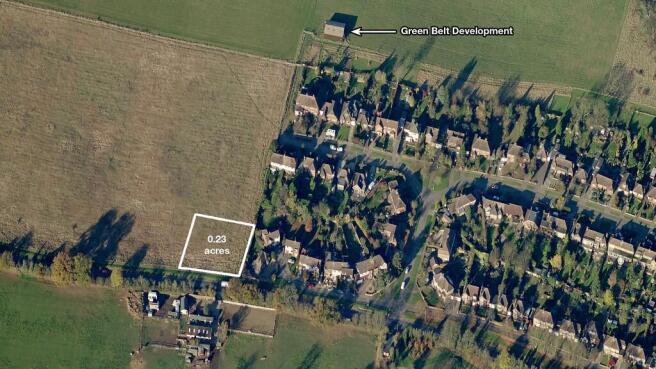
- Residential-sized plot of agricultural land.
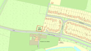
- Measuring 0.23 acres (934 sq.m.).
- Bordering a residential estate.
- Benefiting from 33m of road frontage onto Lower Luton Road.
- Desirable position midway between Wheathampstead & Harpenden.
- Within walking distance of the new Katherine Warington School.
- Close to excellent transport links.
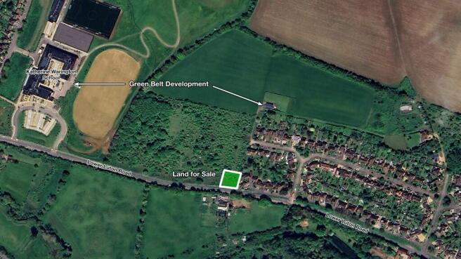
- There has been development within the Green Belt close to the land.
- No overage or clawback - rare in today's land market!
- Download the brochure using the link below.
Description
This a desirable opportunity for you to own a residential-sized plot of agricultural land, bordering a residential estate.
The plot measures 0.23 acres (934 sq.m.) and benefits from road frontage onto Lower Luton Road, adjacent to the large detached house at No. 386.
Situated in a desirable position, the land is located midway between the sought-after areas of Wheathampstead and Harpenden, and within walking distance of the new Katherine Warington School.
Transport links are excellent. The M1 & A1(M) connect you to the M25, whilst nearby Harpenden train station offers direct links to London in just 26 minutes.
The land is currently overgrown and could be suitable for a variety uses subject to any necessary planning consents.
It should be noted that there has been development within the Green Belt close to the land for sale.
LOCAL DEVELOPMENT
Just 175m north of the land for sale, a plot of land was given approval in 2004 for a 148m2 agricultural building (Planning Ref. 5/2004/0099).
Following this, an application was made in 2017 to convert the barn into a 3-bed home (Planning Ref. 5/2017/1211). Though this application was originally refused, it was successfullly given approval under appeal (Appeal Ref: APP/B1930/W/17/3180423).
A further application was approved in 2019 to change this to a 4-bed home (Planning Ref. 5/2019/1548).
The curtilage of this property is not to dissimilar in size to the land for sale and both sites have the same land designation.
Furthermore, the new Katherine Warington School was granted planning permission on Green Belt land in 2018.
LOCAL AUTHORITY
St Albans City & District Council
LAND DESIGNATION
The land is situated within a Landscape Conservation Area and the Metropolitan Green Belt. Any development or change of use would be subject to the appropriate permission.
PLANNING
The land is subject to an Article 4 Direction. There are no current or past planning applications on the land.
NO OVERAGE
There is no overage or clawback on this land - rare in today's land market.
PROPERTY PRICES
The land is situated within an extremely affluent area. Property prices in the Wheathampstead & Harpenden area are 51% above the county average and 123% above the national average. These premium house prices reflect the desirability of the area as a place to live and own property - including land.
LOCATION
- West of Wheathampstead
- East of Harpenden
- 4.8 miles to St. Albans
- 5.4 miles to Welwyn Garden City
- 5.5 miles to Hatfield
- 5.6 miles to Luton
- 11.8 miles to Watford
- 23.3 miles to Central London
The plot of land adjoins a residential estate on the Lower Luton Road, just a short walk from the new Katherine Warington School, which has received a good & outstanding Ofsted report.
It lies in an enviable position mid-way between Wheathampstead and Harpenden.
The historic and charming riverside village of Wheathampstead was voted one of "The Sunday Times Best Places to Live" in 2023 and it's easy to see why; with a thriving local community, day-to-day amenities and highly-rated restaurants.
Wheathampstead is complimented by Harpenden - one of the UK's most sought-after locations, with its excellent schools and leafy Victorian High Street, which boasts a variety of outstanding boutique shops, cafés, bars and restaurants.
Transport links are excellent. The M1 and A1(M) are both close by providing easy access to the M25.
Nearby Harpenden train station offers regular services to St. Albans and Luton Airport Parkway in just 5 minutes, with direct services to London St. Pancras International in as little as 26 minutes.
TRANSPORT LINKS
- 1.1 miles to Harpenden Train Station*
- 3.9 miles to the M1 (J9)
- 4.4 miles to London Luton Airport
- 4.6 miles to the A1(M)
- 7.6 miles to the M25 (J21a)
* Journey Times: 5 mins to Luton Airport Parkway; 5 mins to St. Albans City; 17 mins to West Hampstead Thameslink; 26 mins London St. Pancras International
ACCESS
The property benefits from approx. 33m of road frontage onto the Lower Luton Road. Full vehicular right of way is provided via an easement from the end of Manor Road.
WHAT3WORDS
The entrance from Manor Road can be found here - ///mute.worm.battle
The approximate location of the land can be found here - ///rush.secure.newly
METHOD OF SALE
The land is offered for sale by private treaty. The freehold is available with vacant possession on completion.
VIEWING
Please contact Vantage Land for viewing instructions.
Brochures
Adj. to 386 Lower Luton Road, Between Wheathampstead & Harpenden

NEAREST STATIONS
Distances are straight line measurements from the centre of the postcode- Harpenden Station1.2 miles
- Luton Parkway Station4.7 miles
- St. Albans Station4.9 miles
Notes
Disclaimer - Property reference Wheathampstead023. The information displayed about this property comprises a property advertisement. Rightmove.co.uk makes no warranty as to the accuracy or completeness of the advertisement or any linked or associated information, and Rightmove has no control over the content. This property advertisement does not constitute property particulars. The information is provided and maintained by Vantage Land & Property, Harpenden. Please contact the selling agent or developer directly to obtain any information which may be available under the terms of The Energy Performance of Buildings (Certificates and Inspections) (England and Wales) Regulations 2007 or the Home Report if in relation to a residential property in Scotland.
Map data ©OpenStreetMap contributors.