
Land At Morton Fen, Morton, Bourne, Lincolnshire, PE10
- PROPERTY TYPE
Bungalow
- BEDROOMS
2
- BATHROOMS
1
- SIZE
Ask agent
- TENUREDescribes how you own a property. There are different types of tenure - freehold, leasehold, and commonhold.Read more about tenure in our glossary page.
Freehold
Key features
- Approximately 685 acres of Grade 2 land in the Lincolnshire Fens
- Detached bungalow
- Set of traditional farm buildings offering scope for a number of potential alternative uses
- The land benefits from good roadside access
- Summer Abstraction Licenses
- EPC Rating = G
Description
Description
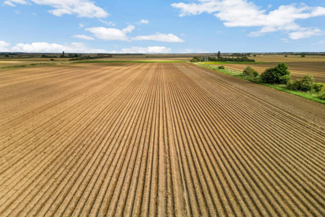
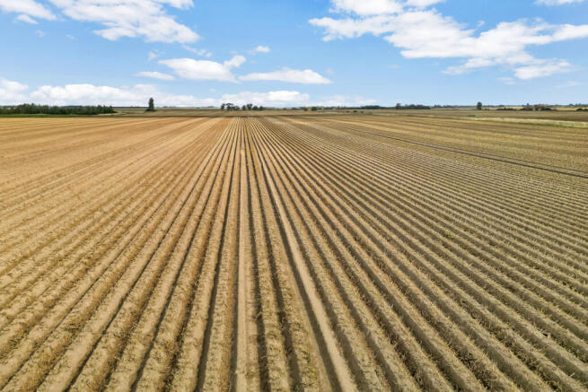
The land at Morton Fen is a largely ring fenced block of productive farmland, sitting north and south of Morton Drove, extending to approximately 685.33 acres of Grade 2 land. The farm sits to the northeast of Bourne, west of Spalding and west of the South Forty Foot Drain.
The land lies largely in a ring fence with a public highway dividing the lots, enabling good access throughout. The land consists of large, workable fields which benefit from classic fenland drainage to support efficient and versatile farming operations. The land is capable of growing a wide variety of crops including brassicas, potatoes, sugar beet and combinable crops.
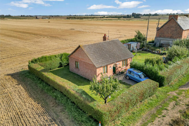
A residential bungalow is situated in the north-eastern corner of the holding, with a range of traditional buildings lying immediately to the south, offering potential for redevelopment.
LOT 1 - FARMLAND NORTH OF MORTON DROVE
The land extends to approximately 331.99 acres (134.35 hectares), situated to the north of Morton Drove and lying to the west of the South Forty Foot Drain. The holding comprises around 324.69 acres of productive arable farmland, with the balance made up of a small wooded area together with miscellaneous tracks and grass verges.
The majority of the land is classified as Grade 2 according to the Provisional Agricultural Land Classifications, with an area of Grade 1 land located to the north-east of Lot One. The majority of the soils form part of the Wallasea 2 soil series, described as deep stoneless clayey soils and deep calcareous silty soils. A small portion of the land forms part of the Wisbech soil series classed as deep stoneless calcareous coarse silty soils.
These soil series are both capable of growing sugar beet, potatoes, winter cereals and field vegetables.
The farmland benefits from a summer abstraction license from the South Forty Foot Drain, details of which are available upon request.
BUNGALOW AND TRADITIONAL BUILDINGS
Lot One also includes, on the north-eastern edge of the block, a two-bedroom bungalow situated at the head of Morton North Drove, the property is occupied under an Assured Shorthold Tenancy, the rent passing is £320 PCM.
Adjoining the bungalow to the south is a range of traditional former farm buildings, which present potential for alternative uses, subject to securing the necessary planning consents.
LOT 2 - LAND SOUTH OF MORTON DROVE
The land extends to approximately 353.34 acres (142.99 hectares), lying to the south of Morton Drove, bounded by the South Forty Foot Drain to the east and New Drain to the south. The holding comprises a substantial block of arable fields, accessed directly from Morton Drove and served by a network of internal grass tracks. Lot Two includes approximately 341.80 acres of highly productive arable land, with the remainder consisting of tracks and grass verges.
The land is classified as Grade 2 throughout and is particularly well-suited to the cultivation of potatoes, sugar beet, cereals, and other combinable crops. The soils form part of the Wallasea 2 soil series, described as deep stoneless clayey soils and deep calcareous silty soils.
These soil series are both capable of growing sugar beet, potatoes winter cereals and field vegetables.
The farmland also benefits from a Summer Abstraction Licence from both the South Forty Foot Drain and New Drain, further supporting the land’s agricultural potential. Full details are available upon request.
Location
The Land at Morton Fen is 4.5 miles from Bourne and 5.5 miles from Spalding, offering a range of local amenities. For more extensive facilities, the cathedral city of Peterborough is 15.5 miles south, offering a wide range of shopping, leisure and cultural attractions. Nearby schools include the highly regarded Bourne Grammar School, with a choice of primary schools in both Spalding and Bourne. The area is also well served by independent schools such as Stamford, Oakham, Oundle and Uppingham.
Road: Morton Fen benefits from good local road links, with the A15 and A16 providing convenient access to nearby towns and cities including Lincoln and Peterborough plus the Lincolnshire Wolds and coast. The A1, approximately 15.5 miles to the west, connects directly into the wider national motorway network.
Rail: Peterborough train station, approximately 22 miles away, provides fast services to London King’s Cross in around 55 minutes, as well as direct connections to York in just over an hour.
Air: East Midlands Airport is located approximately 49 miles away, offering a range of domestic and international flights.
Disclaimer: All journey times and distances are approximate.
Acreage: 680.69 Acres
Additional Info
Local Authority: South Kesteven District
Tax Band: A
Photographs and Particulars: September 2025
Brochures
Web Details- COUNCIL TAXA payment made to your local authority in order to pay for local services like schools, libraries, and refuse collection. The amount you pay depends on the value of the property.Read more about council Tax in our glossary page.
- Band: A
- PARKINGDetails of how and where vehicles can be parked, and any associated costs.Read more about parking in our glossary page.
- Ask agent
- GARDENA property has access to an outdoor space, which could be private or shared.
- Ask agent
- ACCESSIBILITYHow a property has been adapted to meet the needs of vulnerable or disabled individuals.Read more about accessibility in our glossary page.
- Ask agent
Land At Morton Fen, Morton, Bourne, Lincolnshire, PE10

Add an important place to see how long it'd take to get there from our property listings.
__mins driving to your place
Affordability
Get an instant, personalised result:
- Show sellers you’re serious
- Secure viewings faster with agents
- No impact on your credit score
Notes
Staying secure when looking for property
Ensure you're up to date with our latest advice on how to avoid fraud or scams when looking for property online.
Visit our security centre to find out moreDisclaimer - Property reference LIR250130. The information displayed about this property comprises a property advertisement. Rightmove.co.uk makes no warranty as to the accuracy or completeness of the advertisement or any linked or associated information, and Rightmove has no control over the content. This property advertisement does not constitute property particulars. The information is provided and maintained by Savills Rural Sales, Lincoln. Please contact the selling agent or developer directly to obtain any information which may be available under the terms of The Energy Performance of Buildings (Certificates and Inspections) (England and Wales) Regulations 2007 or the Home Report if in relation to a residential property in Scotland.
*This is the average speed from the provider with the fastest broadband package available at this postcode. The average speed displayed is based on the download speeds of at least 50% of customers at peak time (8pm to 10pm). Fibre/cable services at the postcode are subject to availability and may differ between properties within a postcode. Speeds can be affected by a range of technical and environmental factors. The speed at the property may be lower than that listed above. You can check the estimated speed and confirm availability to a property prior to purchasing on the broadband provider's website. Providers may increase charges. The information is provided and maintained by Decision Technologies Limited. **This is indicative only and based on a 2-person household with multiple devices and simultaneous usage. Broadband performance is affected by multiple factors including number of occupants and devices, simultaneous usage, router range etc. For more information speak to your broadband provider.