
Land at Woodberry Lane, Rowland's Castle
- PROPERTY TYPE
Land
- SIZE
186,437 sq ft
17,321 sq m
Key features
- SEE AND PRINT PDF SALES PARTICULARS AVAILABLE BELOW
- SEE DRONE VIDEO FOOTAGE ON THE VIRTUAL TOUR TAB
- APPROX. 4.28 ACRES (1.73 HA) OF PASTURELAND
- CONVENIENT LOCATION ON THE EDGE OF ROWLAND'S CASTLE
- APPROX. 2.5 MILES FROM JUNCTION 2 of the A3(M)
- EXCELLENT LINKS TO THE LOCAL RIGHTS OF WAY NETWORK
- SITUATED CLOSE TO THE BOUNDARY OF THE SOUTH DOWNS NATIONAL PARK (OUTSIDE)
- SUITABLE FOR AMENITY, FORESTRY, RECREATION AND CONSERVATION STP
Description
VIDEO DRONE FOOTAGE: See the Selling Agent's website - further details, photographs and drone video footage is available showing the whole property.
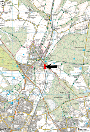
LOCATION: See Location Plan. Postcode: PO9 6EP.
What3Words (Access Gate): Improvise.windy.elect
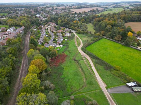
DESCRIPTION: The property extends to approx. 4.28 acres (1.73 Ha). It mainly comprises pastureland with a small area of woodland/scrub at the south-western corner between the property and the railway (Portsmouth Direct Line). The residential area of Rowlands Castle is adjacent to the west. The northern and eastern boundaries comprise established native hedging. The southern boundary is post and rail fencing. The western boundary is mostly close board fencing apart with a section of woodland/scrub.
A right of access and bridleway passes across the land north to south from Woodberry Lane. Lavant Stream passes across the land from the north-eastern corner off Woodberry Lane to the southern boundary. The southern part of the land is classified as Grade 3 agricultural land, while the northern part is classified as non-agricultural on the land classification database. The soil is identified as slowly permeable seasonally wet slightly acid but base-rich loamy and clayey soils.
ACCESS: Access to the land is directly from Woodberry Lane at the north western corner. Please see black arrow on Site Plan.
LAND REGISTRY: The property comprises the entirety of Land Registry Title SH29710. There are a number of historic rights and covenants benefitting and burdening the property which are referred to on the Land Registry Title Register, although it is not clear which of these remain enforceable. See Selling Agent's website for Land Registry Title Plans and Registers.
PLANNING HISTORY: No recent planning applications have been identified as relating to the Property.
PLANNING STATUS: The property is located outside of settlement boundaries, although it is adjacent to the Rowland's Castle settlement boundary along much of the western boundary. It is within an area designated "countryside" under the Local Plan.
ARTICLE 4 DIRECTION: As of 16th June 2009, an Article 4 Direction was placed on the land restricting the erection, construction, maintenance, improvement or alteration of a gate, fence, wall or other means of enclosure. The effect of this is that planning consent is likely to be required for the above purposes.
DESIGNATIONS: Much of the land is within Flood Zones 2 and 3 indicated a medium to high probability of flooding. It is within the South Downs National Character Area. The property is not within the South Downs National Park, the boundary being across Woodberry Lane to the north. The eastern part of the land is historic landfill. No other significant environmental/planning designations have been identified.
SERVICES: Based on information that we have been provided, electricity and water are likely to be available nearby but are not currently connected.
TRACKWAY-RIGHT OF WAY: A right of way is in use across the property from the access off Woodberry Lane for the benefit of properties to the south-east. This is indicated by the orange dashed line on the Site Plan.
PUBLIC RIGHTS OF WAY: The property is well situated for access to the local public rights of way network on the edge of Rowland's Castle. A bridleway passes across the property from north to south broadly following the route of the access track/right of way which crosses the property.
LOCAL AUTHORITY: East Hampshire District Council, PO Box 310, Petersfield, GU32 9HN.
Brochures
Sales ParticularsLand at Woodberry Lane, Rowland's Castle

NEAREST STATIONS
Distances are straight line measurements from the centre of the postcode- Rowlands Castle Station0.2 miles
- Warblington Station2.5 miles
- Havant Station2.7 miles
About Giles Wheeler-Bennett, Southampton
West Court, Lower Basingwell Street, Bishop's Waltham, SO32 1AJ
Notes
Disclaimer - Property reference WoodberryLn. The information displayed about this property comprises a property advertisement. Rightmove.co.uk makes no warranty as to the accuracy or completeness of the advertisement or any linked or associated information, and Rightmove has no control over the content. This property advertisement does not constitute property particulars. The information is provided and maintained by Giles Wheeler-Bennett, Southampton. Please contact the selling agent or developer directly to obtain any information which may be available under the terms of The Energy Performance of Buildings (Certificates and Inspections) (England and Wales) Regulations 2007 or the Home Report if in relation to a residential property in Scotland.
Map data ©OpenStreetMap contributors.