
Lydacott, Barnstaple
- PROPERTY TYPE
Detached
- BEDROOMS
4
- BATHROOMS
1
- SIZE
2,449 sq ft
228 sq m
- TENUREDescribes how you own a property. There are different types of tenure - freehold, leasehold, and commonhold.Read more about tenure in our glossary page.
Freehold
Key features
- A mixed farm situated near to the River Taw Estuary
- 194.90 Acres (78.89 Hectares)
- A characterful house for modernisation (4 bedrooms)
- A separate cottage for renovation (3 bedrooms)
- A range of stone & cob barns with potential for alternative uses (subject to planning)
- Further modern style farm buildings and stables
- A detached barn with planning consent for conversion
- Undulating pasture and arable land with excellent road frontage.
- Freehold. EPC: Band G. Council Tax: Bands D & B
- Available as a whole or in 6 lots.
Description
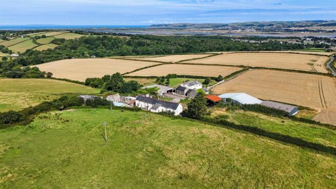
Situation - Higher Lydacott Farm is situated in a very appealing location, surrounded by rolling countryside with views from the farm over the River Taw estuary, yet only a short distance from Barnstaple and the A39.
The village of Fremington is one mile to the north of the farm and the nearby Fremington Quay (2.4 miles) is on the banks of the River Taw and provides direct access to the Tarka Trail between Barnstaple and Instow.
The coastal village of Instow with its renowned sandy beach is approximately 4 miles to the west of the farm whilst the historic port town of Bideford is within 5.5 miles.
The regional centre of Barnstaple (town centre 3.6 miles) provides all the area's main business, shopping and commercial facilities and also has rail services to Exeter along the scenic Tarka Line. There are also good transport links with the A39 at Roundswell (2.3 miles) which links to the A361 and the M5 motorway (Junction 27).
North Devon’s surfing beaches of Saunton, Croyde, Putsborough and Woolacombe are on the opposite side of the River Taw estuary but within an easy driving distance of the farm.
Introduction - Higher Lydacott Farm has been within the same family ownership for over eighty years and occupies an enviable location being both rural and very accessible to the coast and nearby road network and with stunning panoramic views from the farm’s land over the River Taw estuary and beyond.
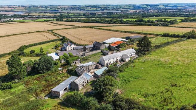
The farmstead is approached over a private entrance lane and includes a characterful house for modernisation with a separate cottage and stone / cob barns which are currently used for stabling and storage but which would be suitable for conversion to alternatives uses, subject to planning consent being obtained.
Away from the main farmstead is a detached barn which has planning consent for conversion to a residential dwelling, surrounded by park-like pasture fields, and the majority of the farm’s land is pasture used for mowing and grazing with a small area used in arable rotation to grow cereal crops.
The land lies at between 70 and 105 metres above sea level and is classified as grade 3 with the soils described as freely draining slightly acid loamy soils.
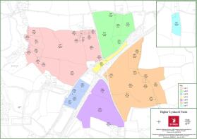
In total Higher Lydacott Farm extends to 194.87 acres (78.86 hectares) and is available as a whole and in up to seven lots.
Lot 1 - Farmhouse, cottage, buildings and land (67.93 acres / 27.49 hectares)
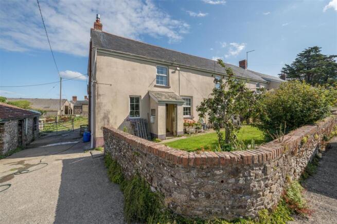
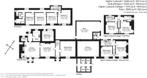
The House - Higher Lydacott Farmhouse is full of character with mostly south-facing windows but is not Listed, constructed of stone, cob and brick with a natural slate roof which was replaced approximately 25 years ago.
On the ground floor the entrance hall has a flagstone floor with a door through to the living room which has an open stone fireplace. The kitchen / breakfast room has a tile floor and a stone fireplace with a bread oven, an oil-fired range cooker and a walk-in larder. The sitting room currently has no floor and there is also a utility room / store to the rear of the house.
On the first floor there are four double bedrooms, all on the south-side of the house and in addition there is a bathroom and a separate w.c.
Outside there are level gardens enclosed with a stone wall planted with a variety of shrubs and flowers and including an apple tree.
The Cottage - The cottage was last occupied approximately 6 years ago and is constructed of stone and cob with a slate roof. The ground floor accommodation includes a kitchen (currently no kitchen units), a dining room with a stone fireplace (oil fire for the hot water) and a sitting room. On the first floor there are two double bedrooms, one single bedroom and a bathroom and to the rear of the cottage is space for a garden.
The Traditional Barns, Stables & Farm Buildings - The Granary (5.36m x 5.13m). This building is between the farmhouse and the cottage, attached to both and has cob and stone walls. Attached to the front of the Granary are some stores and to the rear is a dilapidated stone and brick barn (7.93m x 6.02m) which currently has no roof covering.
To the west of the farmhouse is a courtyard of stone and cob barns which include:
Stables. Stone walls with a clay tile roof. Three stables.
Cider House. Block and stone walls with a corrugated tun roof (some sheets missing).
Shippen. Cob and stone walls with corrugated asbestos roof sheets.
To the rear of the Cider House and Shippen are Four Stables constructed of rendered block walls with timber stable doors and box-profile steel roof sheets.
Cow Barn. Stone walls with a corrugated asbestos roof. This barn has two storeys currently with a loft on the first floor. Attached Loose House with stone walls and a corrugated tin roof.
Open Fronted Barn. Part stone, part block walls with a concrete floor and box profile steel roof sheets.
To the west of the courtyard is:
The Old Stables. Stone walls with a slate roof. There is a cobbled floor and a storage loft on the first floor. Attached to the rear of this building is a General Purpose Barn with concrete block supports, corrugated tin roof sheets and attached to the west side is a Loose House with block walls, corrugated tin roof sheets.
To the rear of the house are:
Three Stables. Rendered block walls with a concrete floor and corrugated asbestos roof sheets.
Two Stables. Rendered block walls with corrugated asbestos roof sheets.
Open Sided Barn. Part steel frame, part timber frame, an earth floor and a partly covered roof with corrugated tin roof sheets.
The Land - The land within LOT 1 is mostly down to grass with a small area of woodland and rush pasture on the north-western boundary. There are four larger fields which are gently sloping and sloping, suitable for mowing and grazing and with access both directly from the farmstead and from the public highway on the southern boundary.
There are far-reaching views from the land over the River Taw estuary and a small stream flows along the western boundary with three further enclosures of rushy pasture and mature woodland towards the north-western corner of this lot.
Lot 2 - Land east of Higher Lydacott (27.74 acres / 11.22 hectares).
The land within LOT 2 comprises four fields which have a north-facing aspect and are used for mowing and grazing. There is direct road access and road frontage on three boundaries and stunning views over the River Taw estuary and beyond. There is also a small copse on the northern boundary.
DEVELOPMENT UPLIFT (OVERAGE): LOT 2 will be sold subject to a development uplift (overage) provision on the following terms: Upon planning consent being granted for any residential or commercial development on the land within a 30 year period from the completion date, the sellers will receive 25% of the increase in value.
Lot 3 - Barn for Conversion with ‘Shed Fields’ (8.26 acres / 3.35 hectares).
Lot 3 comprises a detached barn which has planning consent under class Q for its conversion to a residential dwelling with two pasture fields.
The approved plans are for a single storey dwelling with an open plan kitchen, dining and living space, four double bedrooms (two with en-suite shower rooms), a bathroom and a utility room with a separate cloakroom.
The two grass fields are gently sloping and include some in-field trees which create a park-like setting and the A39 forms the south-eastern boundary.
Lot 4 - Paddock (3.08 acres / 1.25 hectares).
Lot 4 is a grass paddock which is gently sloping with a north-east facing aspect. This lot has direct access onto the public highway which forms the northern boundary.
Lot 5 - Land (26.21 acres / 10.60 hectares).
Lot 5 comprises two level and gently sloping fields with direct road access. The northern field is currently grass and used for grazing whilst the larger southern field has been used to grow cereal crops.
Lot 6 - Land (57.94 acres / 23.46 hectares).
Lot 6 lies on the southern side of the A39 and includes a large open grass field which is gently sloping and two smaller fields which lie wetter and include some rush pasture. In addition there is a small paddock on the western boundary and two small areas of copse, one of which includes a pond.
Lot 7 - LOT 7: Land (3.74 acres / 1.52 hectares).
Lot 7 lies to the north of the main farm, a short distance to the south of the village of Fremington. This lot is a single gently sloping grass field with a north-facing aspect and is known as Path Field. There is direct road access.
Services - LOT 1: Mains water (metered). Mains electricity. Private drainage (treatment plant installed in 2024). No central heating. Oil fired range provides hot water.
LOT 2: No services connected.
LOTS 3 and 4: Mains water is connected. If sold separately to LOT 1 the purchasers of LOTS 3 and 4 are to establish a new connection.
LOTS 5, 6 & 7: No services connected. We understand that a mains water pipe passes underneath lots 5 and 6.
Based on information from Ofcom mobile phone coverage is likely with EE, O2, Three & Vodafone. Ofcom predicted broadband availability is Standard (1 Mbps upload to 2 Mbps download).
Tenure - The property is owned freehold and is registered on the Land Registry.
The land is currently let on a grazing licence (until the 31st March 2026).
Planning - The barn within LOT 3 has planning consent for conversion to a residential dwelling under class Q (Reference: 80237). The decision date was the 23rd June 2025.
Local Authority - North Devon District Council.
Council Tax: Farmhouse: Band D. The Cottage: Band B.
Designations & Land Management - The property is not within an Area of Outstanding Natural Beauty (AONB) but is within a Nitrate Vulnerable Zone (NVZ).
There are no land management agreements in place.
Sporting And Mineral Rights - The sporting and mineral rights insofar as they are owned are included with the freehold.
Wayleaves & Rights Of Way - The property is sold subject to and with the benefit of any wayleave agreement and any public or private rights of way that may affect it.
There are no public footpaths passing through the farm.
There are underground electricity cables passing through some of the lots and no structures or buildings can be constructed over the route of these cables.
Viewing - Strictly by prior appointment with Stags. Please call to arrange an appointment or email: .
Directions - From the Roundswell roundabout on the A39 to the south of Barnstaple, proceed north towards Bickington and Fremington and continue straight across at the first roundabout and turn left at the second roundabout signed towards Holmacott and Eastleigh.
Follow this road, onto The Old Bideford Road and continue for 1.7 miles. Upon reaching Lovacott Cross turn right towards Fremington and the entrance to Higher Lydacott Farm will be on the left after 0.15 miles.
What3words - Reference/// gifts.handbook.bypasses
Disclaimer - Stags gives notice that: 1. These particulars are a general guide to the description of the property and are not to be relied upon for any purpose. 2. These particulars do not constitute part of an offer or contract. 3. We have not carried out a structural survey and the services, appliances and fittings have not been tested or assessed. Purchasers must satisfy themselves. 4. All photographs, measurements, floorplans and distances referred to are given as a guide only. 5. It should not be assumed that the property has all necessary planning, building regulation or other consents. 6. Whilst we have tried to describe the property as accurately as possible, if there is anything you have particular concerns over or sensitivities to, or would like further information about, please ask prior to arranging a viewing.
Warning - Farms and land can be dangerous places. Please take care when viewing the property, particularly in the vicinity of farm buildings and livestock.
Brochures
Higher Lydacott Farm 12pp.pdf- COUNCIL TAXA payment made to your local authority in order to pay for local services like schools, libraries, and refuse collection. The amount you pay depends on the value of the property.Read more about council Tax in our glossary page.
- Band: D
- PARKINGDetails of how and where vehicles can be parked, and any associated costs.Read more about parking in our glossary page.
- Ask agent
- GARDENA property has access to an outdoor space, which could be private or shared.
- Yes
- ACCESSIBILITYHow a property has been adapted to meet the needs of vulnerable or disabled individuals.Read more about accessibility in our glossary page.
- Ask agent
Lydacott, Barnstaple

Add an important place to see how long it'd take to get there from our property listings.
__mins driving to your place
Get an instant, personalised result:
- Show sellers you’re serious
- Secure viewings faster with agents
- No impact on your credit score


Your mortgage
Notes
Staying secure when looking for property
Ensure you're up to date with our latest advice on how to avoid fraud or scams when looking for property online.
Visit our security centre to find out moreDisclaimer - Property reference 34268115. The information displayed about this property comprises a property advertisement. Rightmove.co.uk makes no warranty as to the accuracy or completeness of the advertisement or any linked or associated information, and Rightmove has no control over the content. This property advertisement does not constitute property particulars. The information is provided and maintained by Stags, Exeter. Please contact the selling agent or developer directly to obtain any information which may be available under the terms of The Energy Performance of Buildings (Certificates and Inspections) (England and Wales) Regulations 2007 or the Home Report if in relation to a residential property in Scotland.
*This is the average speed from the provider with the fastest broadband package available at this postcode. The average speed displayed is based on the download speeds of at least 50% of customers at peak time (8pm to 10pm). Fibre/cable services at the postcode are subject to availability and may differ between properties within a postcode. Speeds can be affected by a range of technical and environmental factors. The speed at the property may be lower than that listed above. You can check the estimated speed and confirm availability to a property prior to purchasing on the broadband provider's website. Providers may increase charges. The information is provided and maintained by Decision Technologies Limited. **This is indicative only and based on a 2-person household with multiple devices and simultaneous usage. Broadband performance is affected by multiple factors including number of occupants and devices, simultaneous usage, router range etc. For more information speak to your broadband provider.
Map data ©OpenStreetMap contributors.