The Causeway, Undy, NP26
Business rates & charges may apply

- SIZE
Ask agent
- SECTOR
Land for sale
Key features
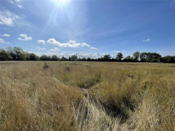
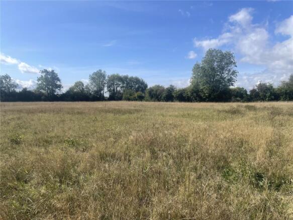
- Approximately 4.71 acres (1.91 ha)
- of level-lying, permanent pastureland
- Conveniently located on the
- outskirts of Undy
- Suitable for a range of uses including
- agricultural, equestrian or amenity
- subject to planning (STP)
Description
permanent pastureland, enclosed by a combination of mature, tree-lined hedgerows and singlestrand barbed-wire fencing. The land is well suited to agricultural, equestrian or amenity use
(subject to planning).
GENERAL REMARKS
An attractive and well-positioned parcel of approximately 4.71 acres (1.91 ha) of level-lying permanent pastureland, enclosed by a combination of mature, tree-lined hedgerows and singlestrand barbed-wire fencing. The land is well suited to agricultural, equestrian or amenity use (subject to planning).
SITUATION
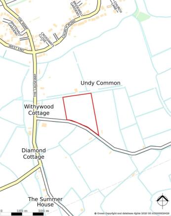
The land is situated on the southern edge of the village of Undy, occupying a rural yet accessible position between Magor (1.1 miles) and Rogiet (2.4 miles) within the County of Monmouthshire. The land benefits from excellent connectivity within proximity to the B4245 (0.5 miles) and Junction 23A of the M4 Motorway Network (2.0 miles).
SERVICES
We are not aware of any mains services connected to the land; however, Purchasers are advised to make their own enquiries with the relevant providers for any service connections in the local vicinity. The adjoining reens provide a natural water source for livestock.
ACCESS
The land benefits from direct roadside access from Norton Lane to the South, with additional access provided by a historic green lane leading off The Causeway to the North.
DESIGNATIONS
The land is designated as being within an Area of Archaeological Sensitivity and is located within the Gwent Levels – Magor and Undy Site of Special Scientific Interest. Purchasers are advised to make their own enquiries as to any additional designations which exist on the land
TENURE
Freehold with vacant possession upon completion.
BOUNDARIES
The Purchaser shall be deemed to have full knowledge of the boundaries and neither the Vendor nor the Agent should be required to produce evidence as to the ownership of the boundaries.
LOTTING & RESERVE
It is anticipated that the property will be offered as shown but the Vendor reserves the right to withdraw, alter or amend the extent of the property being offered.
EASEMENTS, COVENANTS & RIGHTS OF WAY
The land is sold subject to any rights, benefits or incidents of tenure which affect it
DIRECTIONS
From Magor, proceed south-west along the B4245 towards Undy. After approximately 0.6 miles, turn right onto The Ramp which connects to The Causeway. Proceed for approximately 0.3 miles and the historic green-lane is on the left, along which the entrance to the land can be found after approximately 0.1 miles. When using the Mobile application – What Three Words: ///satellite.deprive.science
VIEWING
At any reasonable daylight hour with a set of sales particulars to hand and with the usual courtesy shown to the owner/occupier. Please contact David James’ Magor Office in advance to inform them and register your interest on .
GUIDE PRICE
Offers in Excess of £75,000 (Seventy-Five Thousand Pounds)
LOCAL AUTHORITY
Monmouthshire County Council –
Brochures
The Causeway, Undy, NP26

NEAREST STATIONS
Distances are straight line measurements from the centre of the postcode- Severn Tunnel Junction Station1.6 miles
- Caldicot Station2.3 miles
- St. Andrews Road Station6.5 miles
Notes
Disclaimer - Property reference WER250167. The information displayed about this property comprises a property advertisement. Rightmove.co.uk makes no warranty as to the accuracy or completeness of the advertisement or any linked or associated information, and Rightmove has no control over the content. This property advertisement does not constitute property particulars. The information is provided and maintained by David James, Magor. Please contact the selling agent or developer directly to obtain any information which may be available under the terms of The Energy Performance of Buildings (Certificates and Inspections) (England and Wales) Regulations 2007 or the Home Report if in relation to a residential property in Scotland.
Map data ©OpenStreetMap contributors.