
Land at Millthorpe, Pointon
- PROPERTY TYPE
Land
- SIZE
Ask agent
Key features
- Residential Development Land
- P.P for the demolition of the existing grain store
- Erection of two dwellings with associated garages
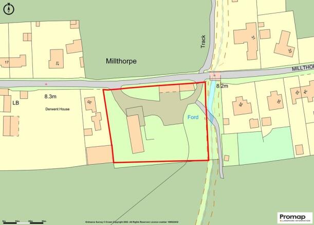
- The site extends to approximately 0.41 hectares / 1.032 acres
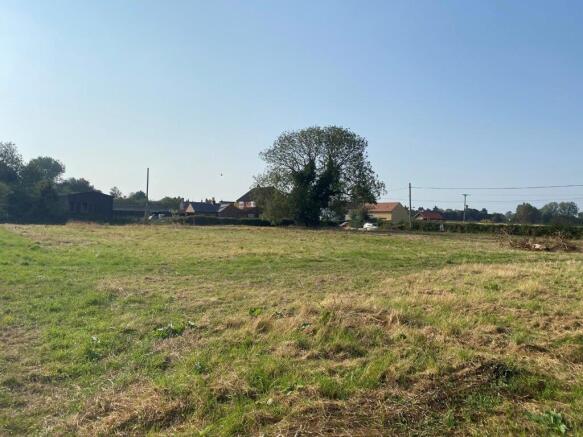
Description
The site, which is generally level, has been a farmyard and includes a former disused grain storage and drying building which extends to approx. 29.10m x 7.85m (Gross External Area). Additionally, there are two single story buildings that boarder Millthorpe Drove. These extend to approx. 6.20m x 16.00m and 5.00m x 10.30m (Gross External Areas) respectively. The vendor does not intend to demolish any buildings or do any more work onsite prior to sale.
The site boarders Millthorpe Drove to the north, a property to the west, agricultural land to the south and a ditch to the east. The unobstructed views to the south provide a spectacular outlook across the Fenland landscape.
PLANNING PERMISSION: Planning Permission was granted on the 11th January 2022 for the demolition of the existing grain store and for the construction of two detached houses with associated garages (following Class Q Prior Approval for the conversion of the grain store to three dwellings).
The proposed dwellings each extend to approx. 187 m2. (2,012 sq. ft.) over two floors - this area excludes the detached garages.
The planning documents can be downloaded from the South Kesteven District Council website - PL Reference: S21/1223.
ACCESS: The site has the benefit of two vehicular access points off Millthorpe Drove.
SERVICES: The site has the benefit of single and three phase electrics (only). The availability and cost of service connection or alterations should be thoroughly explored by prospective purchasers prior to submitting an offer.
BOUNDARIES AND FENCING: Interested parties are responsible for familiarising themselves with the boundaries of the site. Any plans are provided for indicative purposes only and are not to scale. The buyer will be responsible for erecting a fence (to at least 1.2m in height) along the south boundary of the site within three months of completion.
UPLIFT PROVISIONS/CLAWBACK CLAUSE: There will be an Uplift Provision/Clawback Clause which will be triggered if Planning Permission for any additional dwellings (i.e., more than two dwellings) is granted in connection with the site. The payment will be due at the rate of 50% of the uplift in value and will be limited to a period of 30 years from the date of completion. The payment will be due on the earlier of implementation of the Planning Permission or the sale of the site.
FLOOD ZONE: The site is situated on the boundary between Flood Zone 2 and Flood Zone 3. Interested parties are encouraged to contact the Environment Agency if they have any further enquiries in this regard.
FOOTPATH: There is a footpath crossing the part of the site. Interested parties are encouraged to contact Lincolnshire County Council if they wish to obtain a definitive map showing the exact location of the footpath
VAT: The sale will be exempt from VAT, but should the sale of the land or any right attached to it become a chargeable supply for the purpose of VAT, such tax shall be payable by the buyer(s) in addition to the contract price.
METHOD OF SALE: The land is offered For Sale by private treaty, initially, as a whole, subject to contract. Perspective purchasers will be asked to comply with Anti Money Laundering regulations and to provide photographic identification in the form of a photocard driving licence or valid Passport, plus a proof of address. Further information is available from the Selling Agents.
VENDOR´S SOLICITOR DETAILS:
Roythornes Solicitors, Enterprise Way, Pinchbeck, Spalding, Lincolnshire. PE11 3YR.
VIEWINGS: All viewings should be arranged with R Longstaff and Co's Bourne Office - . All parties enter the property entirely at their own risk. Please exercise caution in respect of your personal safety and those parties with you at all times. Neither the seller nor their Agent accept any liability for any damage to persons or their property.
Land at Millthorpe, Pointon

NEAREST STATIONS
Distances are straight line measurements from the centre of the postcode- Heckington Station8.1 miles


Notes
Disclaimer - Property reference 101505013723. The information displayed about this property comprises a property advertisement. Rightmove.co.uk makes no warranty as to the accuracy or completeness of the advertisement or any linked or associated information, and Rightmove has no control over the content. This property advertisement does not constitute property particulars. The information is provided and maintained by Longstaff Eckfords, Bourne. Please contact the selling agent or developer directly to obtain any information which may be available under the terms of The Energy Performance of Buildings (Certificates and Inspections) (England and Wales) Regulations 2007 or the Home Report if in relation to a residential property in Scotland.