
Land for sale
Temple Dinsley Park, Hitchin SG4 7RT

- PROPERTY TYPE
Land
- SIZE
Ask agent
Key features
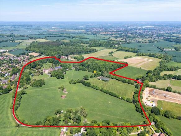
- 70.00 acres
Description
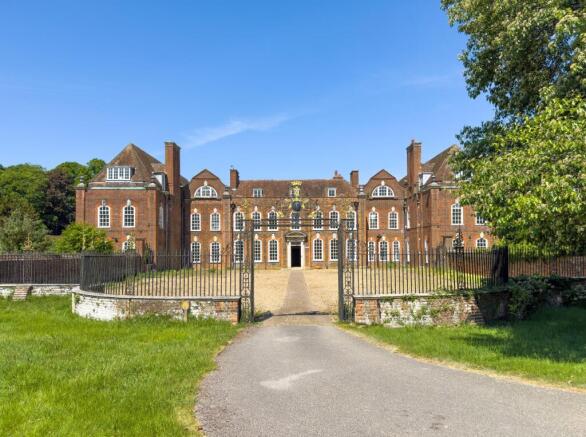
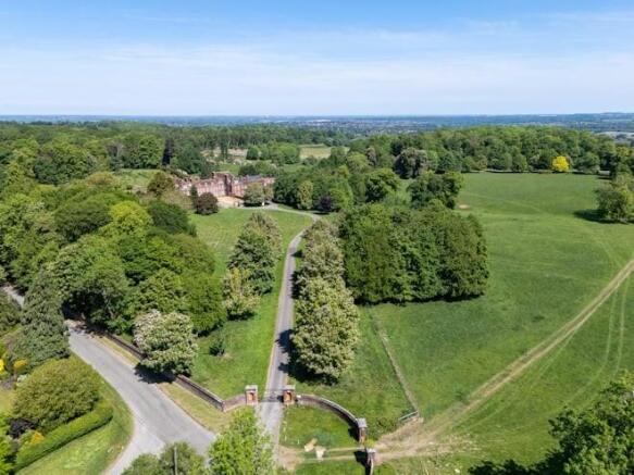
The site expands across 68.7 acres (27.8 ha), featuring a Grade II* listed building designed by Sir Edwin Lutyens with associated gardens by Gertrude Jekyll, all set within expansive grounds and woodlands.
The site has received listed building consent and planning permission for a partial conversion and new-build development, providing for 69 private residential dwellings comprising a mix of 26 houses and 43 apartments. (24/01604/FP and 24/01605/LBC).
The site is conveniently located just 4 miles from Hitchin Station, offering direct services to London King's Cross in just 35 minutes. It also enjoys excellent motorway access, situated only a 12-minute drive from the A1 and 20 minutes from the M1.
Preferred offers are requested for the freehold interest, on an unconditional basis, only. The Vendor may also consider offers for the different component parts of the site.
The site is located 3 miles south of Hitchin, situated on the outer eastern fringe of the affluent village of Preston, Hertfordshire. The village is surrounded by picturesque agricultural fields, woodlands and close to natural landmarks such as the Pegsdon Hills and Hoo Bit nature reserve. Several renowned schools are just a short 10-minute drive from the area, including the highly respected Hitchin Girls' School, Hitchin Boys' School and Kingshott School, a well-regarded independent preparatory school in Hitchin. The Red Lion Pub is a short walk via a path from the property. The pub offers a selection of local ales and traditional British cuisine, making it a popular spot for both locals and visitors. Preston Recreation Ground is again situated within a short walk of the property and is home to Preston Cricket Club. The open space is popular with residents for both organised sports and
casual recreation. The Mall Luton, is a short 7 miles away and offers a wide array of retail amenities. Furthermore, Stevenage features Westgate Shopping Centre and Roaring Meg Retail Park both within 6 miles, providing even broader retail options.
Brochures
141689_temple-dinsleMore DetailsTemple Dinsley Park, Hitchin SG4 7RT

NEAREST STATIONS
Distances are straight line measurements from the centre of the postcode- Hitchin Station3.1 miles
- Stevenage Station3.3 miles
- Knebworth Station5.1 miles

Notes
Disclaimer - Property reference KRD012545824. The information displayed about this property comprises a property advertisement. Rightmove.co.uk makes no warranty as to the accuracy or completeness of the advertisement or any linked or associated information, and Rightmove has no control over the content. This property advertisement does not constitute property particulars. The information is provided and maintained by Knight Frank Land, London. Please contact the selling agent or developer directly to obtain any information which may be available under the terms of The Energy Performance of Buildings (Certificates and Inspections) (England and Wales) Regulations 2007 or the Home Report if in relation to a residential property in Scotland.
Map data ©OpenStreetMap contributors.