
Garnswllt, Ammanford, Carmarthenshire.
- PROPERTY TYPE
Land
- SIZE
Ask agent
Key features
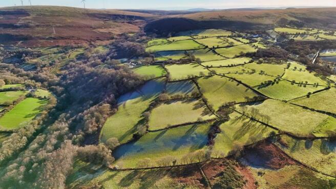
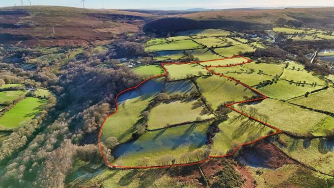
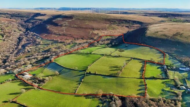
- 96 Acres of Upland Pasture
- Range of Modern Outbuildings
- Located Approximately 2 Miles South of Ammanford
- Overlooking the Loughor Valley
- For Sale By Tender
Description
5 bay steel portal frame general purpose shed (75' x 60') with lean to (75' x 22') with concrete block walls below a box profile and corrugated fibre cement sheet roof.
Recently built 5 bay steel portal frame general purpose shed (75' x 40') with lean to (75' x 22') with concrete panel walls below a corrugated fibre cement sheet roof.
The land is currently used for conventional low input sheep and beef cattle grazing with the less improved land possessing a diverse and rich amount of wildlife, fauna and flora in this upland landscape.
Situation
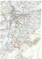
The holding is situated approximately 2 miles south of Ammanford under the slopes of Pen Y Cwar overlooking the Loughor Valley. The property is accessible from a stone trackway which links to the mountain council road between Garnswllt and Felindre. A location plan is enclosed with these particulars.
Services
The holding benefits from a spring fed water supply.
Grazing Rights
The holding benefits from common grazing rights on CL45 and CL74 Common for 440 sheep or 88 cattle. The hefted flock can be purchased at valuation.
Wayleaves, Easements and Rights of Way
The property is sold, subject to, and with the benefit of all existing rights of way, light, support, drainage, water and electricity supplies and other rights and obligations, easements, quasi easements and restrictive covenants and all existing and proposed wayleaves or masts, pylons, stays, cables, drains and water, gas, or other pipes whether referred to in the particulars of sale or not, and to the provisions of any planning scheme or Local Authority.
Health & Safety
Given the potential hazards of rural property all prospective purchasers should take all necessary care when making an inspection. Viewings are taken solely at the risk of those who view and neither the agents nor the owners of the property take responsibility for any injury however caused.
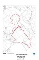
Plans, Areas & Schedules
A copy of the plan is attached for identification purposes only. The purchasers shall be deemed to have satisfied themselves as to the description of the property. An error or mis-statement shall not annul a sale or entitle any party to compensation in respect thereof.
Planning.
No planning enquiries have been made.
Method of Sale
The land will be offered for sale by Informal Tender. Tender forms are to be submitted to the Brecon Office by 12 noon on Friday 9th January 2026. Tender forms are available from the Brecon Office.
Local Authority
Swansea Borough Council, Civic Centre, Oystermouth Road, Swansea, SA1 3SN.
Viewing
Strictly by appointment please through the selling agents Messrs Clee Tompkinson & Francis through whom all negotiations should be conducted. Please contact our Brecon Office .
After Hours
Ashley Symonds .
Tenure
Freehold with vacant possession.
DIRECTIONS
A location plan is enclosed with these particulars.
Garnswllt, Ammanford, Carmarthenshire.

NEAREST STATIONS
Distances are straight line measurements from the centre of the postcode- Pantyffynnon Station1.3 miles
- Ammanford Station2.4 miles
- Llandybie Station4.1 miles


Notes
Disclaimer - Property reference PRG11001. The information displayed about this property comprises a property advertisement. Rightmove.co.uk makes no warranty as to the accuracy or completeness of the advertisement or any linked or associated information, and Rightmove has no control over the content. This property advertisement does not constitute property particulars. The information is provided and maintained by Clee Tompkinson & Francis, Brecon. Please contact the selling agent or developer directly to obtain any information which may be available under the terms of The Energy Performance of Buildings (Certificates and Inspections) (England and Wales) Regulations 2007 or the Home Report if in relation to a residential property in Scotland.
Map data ©OpenStreetMap contributors.