Land at Yew Tree Walk, Stourport-on-severn
£0.47 per sq ft
Business rates & charges may apply
- SIZE AVAILABLE
534,046 sq ft
49,615 sq m
- SECTOR
Land for sale
Key features
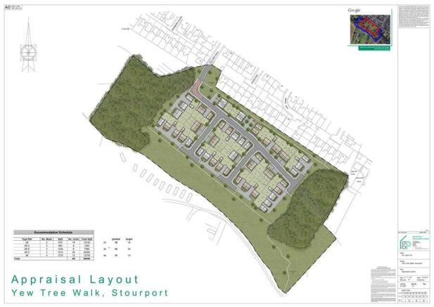
- Development Opportunity (STP) For Sale, Subject to Contract.
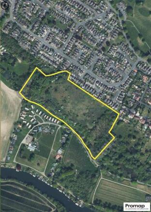
- Total site area: Approximately 12.26 acres (4.96 Hectares).
- For sale on an unconditional basis.
- Offers over £250,000 invited by way of Private Treaty.
Description
The site is bound by existing residential housing to the north, woodland to the east, Stourport Motor Yacht and Bungalow Association to the south, and Lickhill Manor Caravan Park to the west.
The property takes access from Yew Tree Walk, which is connected to Stagborough Way.
In Savills opinion the site presents a sensible grey belt option to deliver housing to meet the needs of demand locally and the wider the Wyre Forest District. Savills, jointly with the landowner, encourage an early planning application.
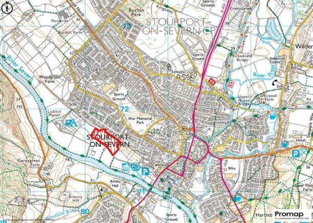
The site is located in Stourport-on-Severn, situated approximately 0.7 miles (1.1 km) west of the town centre. Stourport-on-Severn is a town located in the Wyre Forest District of north Worcestershire. The town is located approx. 4 miles south of Kidderminster, 12 miles north of Worcester, and 23 miles south west of Birmingham. The town offers a range of local amenities and services including, schooling, retail and leisure facilities and is a popular location for commuters working in nearby Kidderminster, Worcester, or Birmingham. Hartlebury railway station is located 3.8 miles (3.2 km) east of the subject site offering regular local and national services between/to Worcester, Birmingham Snow Hill, and Solihull. Junction 5 of the M5 motorway is located c. 10 miles to the east of the subject site providing access to the strategic motorway network including the M6 and M42 motorways.
Brochures
Land at Yew Tree Walk, Stourport-on-severn

NEAREST STATIONS
Distances are straight line measurements from the centre of the postcode- Hartlebury Station3.1 miles
- Kidderminster Station3.6 miles
- Blakedown Station6.6 miles
Notes
Disclaimer - Property reference 67514C9F-4814-4CF4-B7B4-EB297F9FB7B6. The information displayed about this property comprises a property advertisement. Rightmove.co.uk makes no warranty as to the accuracy or completeness of the advertisement or any linked or associated information, and Rightmove has no control over the content. This property advertisement does not constitute property particulars. The information is provided and maintained by Savills, Birmingham. Please contact the selling agent or developer directly to obtain any information which may be available under the terms of The Energy Performance of Buildings (Certificates and Inspections) (England and Wales) Regulations 2007 or the Home Report if in relation to a residential property in Scotland.
Map data ©OpenStreetMap contributors.