Hampton Hill, SO32

- PROPERTY TYPE
Land
- SIZE
137,214 sq ft
12,748 sq m
Key features
- SEE AND PRINT PDF SALES PARTICULARS AVAILABLE BELOW
- SEE DRONE VIDEO FOOTAGE ON THE VIRTUAL TOUR TAB
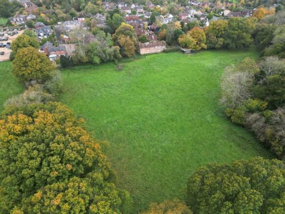
- APPROX. 3.15 ACRES OF PASTURELAND
- ATTRACTIVE LOCATION WITHIN TO SWANMORE
- FIELD SHELTER
- WOODLAND EDGES AND MATURE TREES ON BOUNDARIES
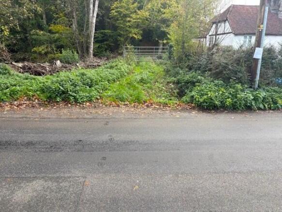
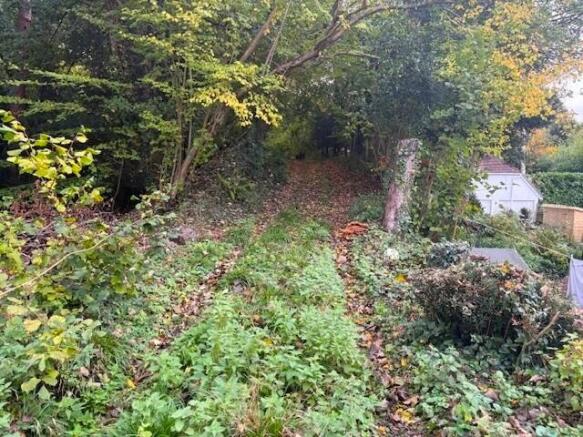
- ACCESS VIA PRIVATE TRACK OFF HAMPTON HILL
- HISTORIC WATER SUPPLY, CURRENTLY TURNED OFF
- SUITABLE FOR AGRICULTURAL, EQUESTRIAN, AMENITY, RECREATION AND CONSERVATION USES (SUBJECT TO PLANNING)
Description
VIDEO DRONE FOOTAGE: See the Selling Agent's website, for further details, photographs, drone video footage is available showing the whole Property.
LOCATION: See Location Plan. SO32 2QN. What 3 Words: Reefs.remission.navigate. Access Off Hampton Hill, Swanmore.
DIRECTIONS: Please see Location Plan and use postcode and What3Words above.
DESCRIPTION: The land extends to approx. 3.15 acres of gently sloping, stock-fenced pastureland with attractive woodland fringes, previously in use for grazing, and quietly positioned on the edge of the sought-after village of Swanmore. Set back from the road and screened by trees and woodland on three sides, the land enjoys a peaceful rural setting with far-reaching potential. Accessed via a private track from Hampton Hill with a historic mains water supply (currently turned off). The parcel lends itself to a wide range of agricultural, equestrian, amenity, recreational and conservation uses, subject to the necessary planning consents.
LAND REGISTRY: The property entirety of Land Registry Title HP577850. Copy available to view on the Selling Agent's website.
PLANNING: There are no recent planning applications affecting the Property. The Property is located outside settlement boundaries in an area designated as Countryside under the South Downs Local Plan.
DEVELOPMENT UPLIFT: The Vendors are mindful to retain a 30% share of any uplift in value caused by Planning Consent for any residential or commercial development on the Property, during a period of 25 years from the completion date of the sale.
RIGHTS AND RESTRICTIONS: There are no public rights of way directly affecting the Property.
ACCESS: Access is via a private access track from Hampton Hill secured by a field gate.
DESIGNATIONS: The Property is situated within the South Downs National Park and within the South Hampshire Lowlands National Character Area. No other significant environmental or planning designations have been identified as affecting the Property.
SERVICES: Water was historically connected to the Property and so the pipework remains. The supply is however currently turned off/disconnected but could likely be reconnected without too much issue.
LOCAL AUTHORITY: Winchester City Council (WCC), City Offices, Colebrook Street, Winchester SO23 9LJ.
PLANNING AUTHORITY: South Downs National Park (SDNP), South Downs Centre, North Street, Midhurst, West Sussex, GU29 9DH.
Brochures
Sales ParticularsHampton Hill, SO32

NEAREST STATIONS
Distances are straight line measurements from the centre of the postcode- Botley Station4.0 miles
- Swanwick Station6.1 miles
About Giles Wheeler-Bennett, Southampton
West Court, Lower Basingwell Street, Bishop's Waltham, SO32 1AJ
Notes
Disclaimer - Property reference HamptonHill. The information displayed about this property comprises a property advertisement. Rightmove.co.uk makes no warranty as to the accuracy or completeness of the advertisement or any linked or associated information, and Rightmove has no control over the content. This property advertisement does not constitute property particulars. The information is provided and maintained by Giles Wheeler-Bennett, Southampton. Please contact the selling agent or developer directly to obtain any information which may be available under the terms of The Energy Performance of Buildings (Certificates and Inspections) (England and Wales) Regulations 2007 or the Home Report if in relation to a residential property in Scotland.
Map data ©OpenStreetMap contributors.