Land for sale
Land at Ashton, nr Oundle, Northamptonshire
Business rates & charges may apply

- SIZE
Ask agent
- SECTOR
Land for sale
Key features
- Farmland and Woodland extending to approximately 353 acres
- Part of the Historic Ashton Estate
- For sale by private Treaty as a whole or in 6 lots
- Good transport links
Description
The land being offered for sale consists of approximately 301.78 acres of arable land, approximately 43.62 acres of woodland and approximately 7.84 acres of permanent pasture.
Location
The land forms part of the historic Ashton Estate and is located in the picturesque Northamptonshire countryside. Located approximately 3 miles to the west of the land is the market town of Oundle offering a range of local services and situated approximately 12 miles to the northwest is the major service centre of Peterborough.
The land is well connected to the local road network with the M1 located approximately 4.2 miles to the east and the A14 located approximately 7.5 miles to the south, both accessible by major A -roads.
Lotting
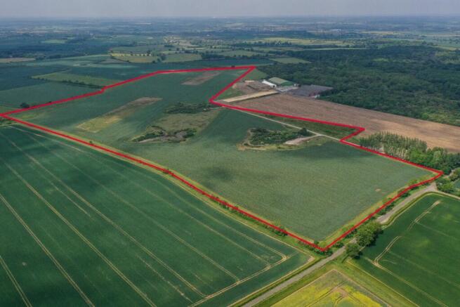
Lot 1 comprises of three parcels of land extending to approximately 167.6 acres (67.83 hectares). The largest parcel (124.63 acres) is to the west of the Lutton Road and was part of the historic Polebrook Airfield. Several areas of concrete yard remain, located off the access track.
At the entrance to the parcel is a hard-cored area of circa 0.55 acres subject to a 999yr lease to the 351st Bombardment group. A smaller (19.24 acres) parcel lies immediately to the southwest. The third parcel (23.72 acres) lies further southwest, off Hemington Road.
The topography of the site is broadly flat. The land is predominantly in arable cultivation with grass margins and small conservation plots which are part of a Countryside Stewardship Mid-Tier scheme ending 31st December 2026.
The land is classified as Grade 3 according to the Natural England Regional Agricultural Land Classification Maps. The soils may be described as Lime-rich loamy and clayey soils with slightly impeded drainage. The harvest 2026 crop is winter wheat.
Lot 2 extends to approximately 35.27 acres (14.27 hectares) in total, across two land parcels off Warmington Road. The topography of the site is broadly flat. The land is predominantly in arable cultivation with grass margins under a Countryside Stewardship Mid-Tier scheme ending 31st December 2026.
The land is classified as Grade 3 according to the Natural England Regional Agricultural Land Classification Maps. The soils may be described as Lime-rich loamy and clayey soils with slightly impeded drainage. The harvest 2026 crop is winter beans.
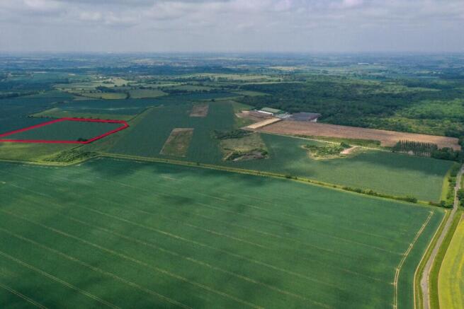
Lot 3 comprises of woodland extending to approximately 4.89 acres (1.98 hectares), with road frontage and direct access off Warmington Road. Predominant species are Norway Spruce and Ash.
The lot includes the site of a telecommunication apparatus which is let to Airwaves under a commercial lease (Landlord & Tenant 1954 Act) with just over 8 years term remaining, and a current passing rent of £2,000 per annum.
Lot 4 extends to approximately 38.73 acres (15.67 hectares) and comprises of mixed-broadleaved woodland, with road frontage and direct access off Warmington Road and Lutton Road. Predominant species are Ash, Birch and Common Oak.
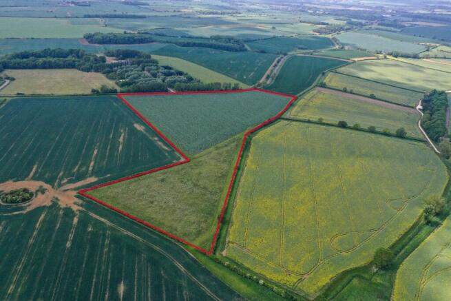
Lot 5 extends to approximately 98.81 acres (39.99 hectares), predominantly in arable cultivation. The land is let under an Agricultural Holdings Act Tenancy, further details of which are available on request. A right of access will be granted to the land via a farm track (classified as a Byway Open to All Traffic) off Tansor Wold road. Oundle School occupy the Rifle Range immediately adjacent. The land is classified as Grade 3 according to the Natural England Regional Agricultural Land Classification Maps. The soils may be described as slightly acid loamy and clayey soils with impeded drainage.
Lot 6 extends to approximately 7.84 acres (3.17 hectares) permanent pasture to the southwest of the village of Tansor. Immediately adjacent to and accessed off the Tansor Road, the parcels are bordered to the northwest by the River Nene.
Location
The land forms part of the historic Ashton Estate and is located in the picturesque Northamptonshire countryside. Located approximately 3 miles to the west of the land is the market town of Oundle offering a range of local services and situated approximately 12 miles to the northwest is the major service centre of Peterborough.
The land is well connected to the local road network with the M1 located approximately 4.2 miles to the east and the A14 located approximately 7.5 miles to the south, both accessible by major A -roads.
Growing Crops
Lots 1 and 2 are farmed under a Contract Farm Agreement. Vacant Possession will be granted on completion subject to the purchaser paying the value of the growing crops.
Services
There are no existing mains electricity or water connections to any of the lots. Boundaries The purchaser must satisfy themselves as to the location of all the boundaries from their own inspections.
Access
Access to all lots is directly from the adopted public highways, with the exception of Lot 5, to which the right of access will be granted along a farm track on retained land. Please note that no highways searches have been undertaken.
Method of Sale
Lots 1-6 are offered for sale by Private Treaty as a whole or in 6 separate lots. The vendor also reserves the right not to accept any offer.
Tenure & Possession
Lots 1, 2, 3, 4 & 6 - Offered freehold with vacant possession. Lot 5 - Offered freehold subject to an Agricultural Holdings Act Tenancy (details available on request).
Wayleaves, Easements & Rights of Way
The land is sold subject to all rights of way, wayleaves and easements whether defined in this brochure or not.
Sporting, Timber and Mineral Rights
The sporting, timber and mineral rights, so far as they are owned, are included within the freehold of the sale.
Overage
The land will be sold subject to an uplift provision which will specify that a percentage of any increase in value due to development (as defined in Section 55 of the Town and Country Planning Act 1990) will be payable to the Vendors or their successors in title should such development occur within a period of years from the date of completion The uplift will be payable upon implementation or on a future sale with the benefit of planning permission for a non-agricultural use.
Viewings
Viewings are strictly by appointment only. The vendor and their agents accept no responsibility for accidents or personal injury as a result of viewings whether accompanied or not.
If you would like to arrange a viewing, please contact Newton LDP.
Brochures
Land at Ashton, nr Oundle, Northamptonshire

NEAREST STATIONS
Distances are straight line measurements from the centre of the postcode- Peterborough Station9.2 miles
Notes
Disclaimer - Property reference EntireAshton. The information displayed about this property comprises a property advertisement. Rightmove.co.uk makes no warranty as to the accuracy or completeness of the advertisement or any linked or associated information, and Rightmove has no control over the content. This property advertisement does not constitute property particulars. The information is provided and maintained by Newton LDP Limited, Stockton. Please contact the selling agent or developer directly to obtain any information which may be available under the terms of The Energy Performance of Buildings (Certificates and Inspections) (England and Wales) Regulations 2007 or the Home Report if in relation to a residential property in Scotland.
Map data ©OpenStreetMap contributors.