Draycott Road, Tean
- PROPERTY TYPE
Land
- SIZE
Ask agent
Key features
- Agricultural land only
- Siutated in the popular village of Tean
- Approximately 5 acres
Description
The Vendor has advised that, based on an informal measurement, the parcel was estimated to be approximately 5 acres. This figure is provided as a general indication only, and prospective purchasers should undertake their own measurements or surveys to verify the exact size.
Enjoying a peaceful rural setting yet conveniently close to local amenities, this is an ideal purchase for those seeking land for agricultural, equestrian, amenity, or leisure use — with the added charm of a private fishing pool and countryside setting.
Access is gained via a shared entrance from Draycott Road, located immediately adjacent to the petrol garage, leading to this appealing piece of Staffordshire countryside.
Access - Vehicular access to the land is via a shared private track from Draycott Road, located beside the petrol garage. The access leads directly to the parcel of land.
Potential Uses - While no planning permission is currently in place, and the land is sold strictly as agricultural land, it may appeal to a wide range of buyers, including:
Equestrian enthusiasts seeking land for grazing or stabling (subject to necessary consents).
Smallholders or hobby farmers wishing to keep livestock, poultry or grow produce.
Outdoor or nature lovers looking for a peaceful private space for recreation, camping, or fishing.
Investors seeking a tangible landholding in a desirable rural area.
Services - We understand that there are no mains services connected to the land. Prospective purchasers should make their own enquiries regarding service availability.
Tenure - We are informed by the Vendors that the property is Freehold, but this has not been verified and confirmation will be forthcoming from the Vendors Solicitors during normal pre-contract enquiries.
Viewing - Viewings may be undertaken at any reasonable time during daylight hours, with a copy of these particulars in hand. Please respect neighbouring properties.
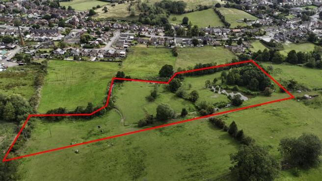
Plan And Boundaries - The land to be sold is shown edged red on the attached plan for identification purposes only. The plan is not to scale and is intended as a general guide to the extent of the parcel being offered for sale.
Prospective purchasers are advised that the exact boundaries, area, and layout of the land will be defined by the title deeds and should be verified by their own inspection and/or legal advisers prior to exchange of contracts.
Prospective purchasers are also encouraged to conduct their own measurements, surveys, and due-diligence inquiries to satisfy themselves as to the exact size of the property. No warranty or representation is made regarding the precise acreage.
Agents Note - Please note that any future development or change of use would be subject to planning consent, and there may be a clawback (overage) clause in favour of the original seller should planning permission ever be obtained.
This land is sold as agricultural land only. No warranty is given or implied regarding the potential for residential or commercial development. Any future planning permission may trigger a clawback clause to the benefit of the original vendor.
Brochures
Draycott Road, TeanBrochureDraycott Road, Tean

NEAREST STATIONS
Distances are straight line measurements from the centre of the postcode- Blythe Bridge Station3.1 miles
Notes
Disclaimer - Property reference 34317845. The information displayed about this property comprises a property advertisement. Rightmove.co.uk makes no warranty as to the accuracy or completeness of the advertisement or any linked or associated information, and Rightmove has no control over the content. This property advertisement does not constitute property particulars. The information is provided and maintained by Kevin Ford and Co Ltd, Cheadle. Please contact the selling agent or developer directly to obtain any information which may be available under the terms of The Energy Performance of Buildings (Certificates and Inspections) (England and Wales) Regulations 2007 or the Home Report if in relation to a residential property in Scotland.