3 bedroom farm house for sale
Tywyll Nodwydd, Pennal, Machynlleth
- PROPERTY TYPE
Farm House
- BEDROOMS
3
- BATHROOMS
1
- SIZE
Ask agent
- TENUREDescribes how you own a property. There are different types of tenure - freehold, leasehold, and commonhold.Read more about tenure in our glossary page.
Freehold
Key features
- Beautiful Countryside Views
- Ring Fenced Holding
- Development Opportunity
- 3 Bedroom Farmhouse
- Pastureland and Woodland
Description
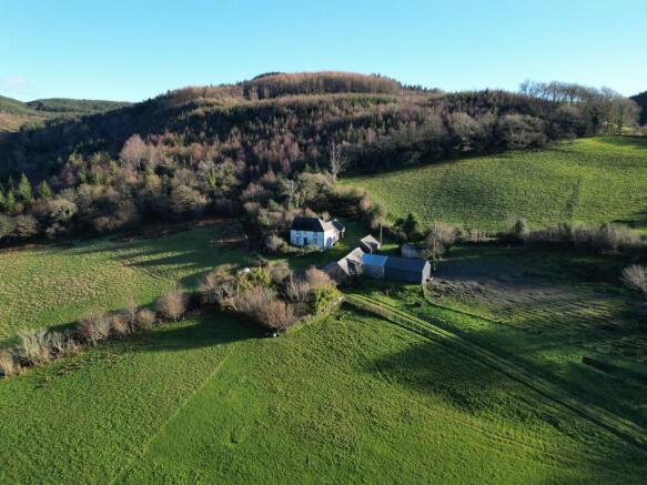
Tywyll Nodwydd sits on the outskirts of Pennal, a picturesque Mid Wales village near the market town of Machynlleth. The peaceful setting enjoys beautiful views of the surrounding hills within Snowdonia National Park. Pennal offers a friendly community with a post office, pub and primary school, while Machynlleth provides wider amenities including cafes, restaurants, leisure facilities and secondary schooling. The area is perfect for outdoor enthusiasts, with walking and cycling routes along the River Dyfi, nearby woodlands and easy access to the Cambrian Mountains.
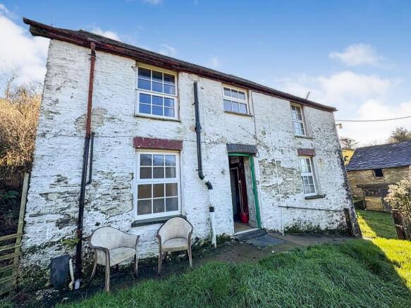
FARMHOUSE & BUILDINGS
The traditional stone farmhouse occupies an elevated position offering delightful views over surrounding farmland and woodland. The property retains a number of charming original features including slate floors, exposed beams and wooden panelled walls, offering a unique blend of rustic charm and spacious living. With careful modernisation, the property offers excellent potential to become a stunning family home. Attached to the farmhouse, and accessed via a small porch-like area, is a traditional stone-built single storey building which is in poor condition. Believed to be the holdings original farmhouse, this building is currently split into two rooms and offers an exciting opportunity for further development into additional living space, subject to obtaining the necessary planning consents.
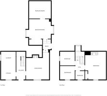
Accommodation:
* Hallway (4.56m x 1.83m)
* Kitchen & Utility (5.49m x 2.88m)
* Lounge (4.52m x 4.22m)
* Hallway (2.01m x 1.49m)
* Rear Extension (6.96m x 4.77m)
* Bedroom 1 (2.90m x 2.66m)
* Bathroom (2.86m x 2.74m)
* Bedroom 2 (1.93m x 1.70m)
* Bedroom 3 (4.31m x 4.75m)
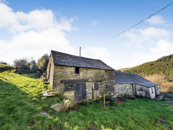
The holding includes the following buildings located south of the farmhouse:
1. Traditional Stone Barn: A barn with slate roof, formerly used as a goat house and feed store, with a hayloft on the upper floor.
2. Stone Workshop Building: White-washed barn and slate construction, originally a cattle shed, now converted into a practical workshop with adjoining food store and potting shed.
3. Open-Sided Agricultural Building: A more contemporary block-built structure with timber purlins and corrugated cladding, offering direct access to rear paddocks; historically used as pig housing.
4. Purpose-Built Chicken Coop
ACCESS & LAND
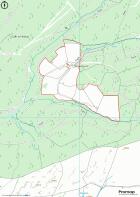
The land stretches across both sides of the access track, amounting to 32.9 acres of pastureland divided into nine manageable enclosures with pockets of ancient woodland, benefitting from water connection. The land is classified as Grade 4 on the Predictive Land Classification Maps. A number of the fields can be directly accessed off the property's access track. Others can be accessed via a small trackway located in the top corner of the yard. All paddocks have been fenced with stock proof netting, with a number also being fenced with a line of barbed wire. The property is approached along a scenic forestry track just off an unnamed highway, which opens onto a private gravelled lane leading directly to the farmstead.
PLANNING
The Eryri National Park website shows the following planning history:
NP5/75/L129D - Rebuilding of part of attached barn at the rear of the dwelling and installation of two rooflights. It is understood that this application has lapsed. Prospective purchasers are advised to undertake their own due diligence.
NP5/75/L129B - Full renovation to the house (withdrawn).
SERVICES
We have been informed that the property benefits from a main supply of electric, private spring-fed water, oil heating system and a septic tank. Please note that the electrics and water have been switched off for insurance purposes.
COUNCIL TAX & LOCAL COUNCIL
Band: D. Cyngor Gwynedd Council, Shirehall Street, Caernarfon, Gwynedd, LL55 1SH
RIGHTS OF WAY & WAYLEAVES
A Public Footpath is designated along the access lane, through the farmstead and a field. There are private rights of way granted detailed with the Land Registry Register. The property will be sold subject to and with the benefit of all wayleaves, easements and rights of way whether mentioned in these particulars or not.
DESIGNATIONS
The property is located within Eryri National Park and Dyfi Biosphere reserve.
BUILDING SURVEY & CONDITION
No formal building survey has been made on the property in the last 12 months. The agents have not undertaken a full survey of the property.
VIEWINGS
Strictly by confirmed appointment with the vendor's agents R G Jones - .
DIRECTIONS
What3Words: ///plodding.pebble.irrigated
ARTICLE 4 DIRECTIVE
If you own a residential dwelling (which is a main home) within the Eryri National Park area and wish to change the use to a second home, short term holiday let or specific mixed use, you will be required to obtain planning permission from Eryri's National Park Authority before undertaking the change of use. If you own a dwelling that is already in use as a second home, short term holiday let or specific mixed uses (before 1 June 2025) - the Article 4 Direction will not affect the current use.
HEALTH & SAFETY
Given the potential hazards of property, we ask you to be as vigilant as possible when making your inspection for your own personal safety.
DISCLAIMER
These particulars, whilst believed to be accurate, are set for guidance only and do not constitute any part of an offer or contract. Intending purchasers or purchasers should not rely on them as statements or representation of fact but must satisfy themselves by inspection or otherwise of their accuracy. No person in the employment of Farmers Marts (R G Jones) Ltd has the authority to make or give any representations or warranty in relation to the property.
Council Tax Band: D (Cyngor Gwynedd Council)
Tenure: Freehold
Brochures
Brochure- COUNCIL TAXA payment made to your local authority in order to pay for local services like schools, libraries, and refuse collection. The amount you pay depends on the value of the property.Read more about council Tax in our glossary page.
- Band: D
- PARKINGDetails of how and where vehicles can be parked, and any associated costs.Read more about parking in our glossary page.
- Driveway,Off street
- GARDENA property has access to an outdoor space, which could be private or shared.
- Front garden,Private garden,Enclosed garden,Rear garden
- ACCESSIBILITYHow a property has been adapted to meet the needs of vulnerable or disabled individuals.Read more about accessibility in our glossary page.
- Ask agent
Tywyll Nodwydd, Pennal, Machynlleth

Add an important place to see how long it'd take to get there from our property listings.
__mins driving to your place
Get an instant, personalised result:
- Show sellers you’re serious
- Secure viewings faster with agents
- No impact on your credit score
Your mortgage
Notes
Staying secure when looking for property
Ensure you're up to date with our latest advice on how to avoid fraud or scams when looking for property online.
Visit our security centre to find out moreDisclaimer - Property reference RS0211. The information displayed about this property comprises a property advertisement. Rightmove.co.uk makes no warranty as to the accuracy or completeness of the advertisement or any linked or associated information, and Rightmove has no control over the content. This property advertisement does not constitute property particulars. The information is provided and maintained by RG Jones, Bala. Please contact the selling agent or developer directly to obtain any information which may be available under the terms of The Energy Performance of Buildings (Certificates and Inspections) (England and Wales) Regulations 2007 or the Home Report if in relation to a residential property in Scotland.
*This is the average speed from the provider with the fastest broadband package available at this postcode. The average speed displayed is based on the download speeds of at least 50% of customers at peak time (8pm to 10pm). Fibre/cable services at the postcode are subject to availability and may differ between properties within a postcode. Speeds can be affected by a range of technical and environmental factors. The speed at the property may be lower than that listed above. You can check the estimated speed and confirm availability to a property prior to purchasing on the broadband provider's website. Providers may increase charges. The information is provided and maintained by Decision Technologies Limited. **This is indicative only and based on a 2-person household with multiple devices and simultaneous usage. Broadband performance is affected by multiple factors including number of occupants and devices, simultaneous usage, router range etc. For more information speak to your broadband provider.
Map data ©OpenStreetMap contributors.