

BEST & FINAL OFFERS INVITED - LOT 2 - Furzeley Road, Waterlooville, Hampshire, PO7
- PROPERTY TYPE
Leisure Facility
- BATHROOMS
1
- SIZE
374,616 sq ft
34,803 sq m
Key features
- SEE AND PRINT PDF SALES PARTICULARS AVAILABLE BELOW
- SEE DRONE VIDEO FOOTAGE ON THE VIRTUAL TOUR TAB
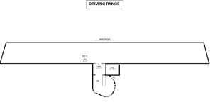
- WELL-ESTABLISHED 16-BAY GOLF DRIVING RANGE SERVING DENMEAD, WATERLOOVILLE AND SURROUNDING AREAS.
- SUBSTANTIAL RANGE BUILDING OF APPROX. 4,760 SQ FT (442.2 SQ M GEA) INCLUDING KITCHEN AND WELFARE SPACE.
- EACH BAY EQUIPPED WITH FOUR TEE SIZES AND QUALITY MATS; CLEAR OUTFIELD VISIBILITY AND STRONG YEAR-ROUND USAGE.
- SELF-SERVICE AUTOMATED BALL-DISPENSING (CARD/CONTACTLESS), OFFERING A LOW-STAFFING OPERATIONAL MODEL.
- CONSENTED UNDER PLANNING APPLICATION 94/00508/OLD WITH ESTABLISHED TRADING HISTORY.
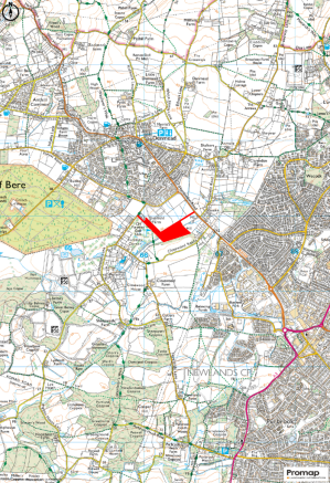
- ACCESS FROM FURZELEY ROAD WITH POTENTIAL FOR SECONDARY ACCESS FROM HAMBLEDON ROAD (STP).
- EXTENDS TO 8.60 ACRES (3.48 HA) IN TOTAL, PROVIDING OPERATIONAL FLEXIBILITY AND SCOPE FOR ENHANCEMENT (STP).
- AVAILABLE AS LOT 2 OF THE WIDER 17.83-ACRE MIXED-USE ESTATE, PURCHASABLE INDIVIDUALLY OR WITH OTHER LOTS IN A WELL-CONNECTED SEMI-RURAL LOCATION.
Description
The Property, including the four bedroomed detached dwelling set within grounds of 2.27 acres (0.91 ha), also offers a well-established 16-bay golf driving range, a combined cattery and 10-stable block (approx. 4,891.7 sq. ft. / 454.45 sq. m GEA), an indoor equestrian arena (approx. 6,042 sq. ft. / 561.32 sq. m GEA) and extensive concrete yard space. Additional outbuildings include a block-and-timber shed (Building 5, approx. 1,091.7 sq. ft. / 101.42 sq. m GEA) and a derelict stable block with office (Building 6, approx. 3,625 sq. ft. / 336.77 sq. m GEA). The Property also includes approximately 5.23 acres (2.11 ha) of level pastureland, ideal for grazing, turnout or further equestrian use.
Offered in four Lots, or as a Whole, the Property presents a rare opportunity to acquire a site of this scale and flexibility, with established infrastructure, income potential and lifestyle appeal, as well as redevelopment potential - all within easy reach of Waterlooville, Portsmouth, the A3(M) and the South Downs.
Driving Range: (See Site Plan)
- Well-established 16-bay driving range in a prominent and accessible location at Furzeley Corner, serving Denmead, Waterlooville, Fareham, Portsmouth and surrounding villages.
- Consented under Planning Application 94/00508/OLD see Planning Section below .
- Each covered bay provides four tee sizes with quality strike mats; the outfield offers clear visibility and an attractive practice environment.
- Self-service operation with automated ball-dispensing, accepting card/contactless payment; low-staffing model with consistent year-round income.
- Current pricing includes £6 per bucket for 60 balls; open daily from 08:00 to 19:00 (seasonal variations).
- Offered as land and buildings only (business not included), providing an opportunity to continue the existing use or adapt the facility subject to planning.
- Access from Furzeley Road with potential for a secondary entrance from Hambledon Road (subject to planning), enhancing operational flexibility.
- Further information available at the Denmead Driving Range website.
Location: The Property is situated at Furzeley Corner, just outside the thriving village of Denmead, which offers a range of everyday amenities including shops, pubs, a primary school and local services. Despite its peaceful semi-rural setting, the Property enjoys excellent connectivity. Waterlooville is just a few minutes' drive to the east, while Junctions 2 and 3 of the A3(M) are approximately 10 minutes away, providing fast road access to Portsmouth, Petersfield, Guildford and London. The A32 and A27 are also within easy reach. Rail services are available from nearby Havant or Petersfield stations, offering regular direct trains to London Waterloo in around 1 hour 20 minutes. Southampton Airport and Portsmouth Ferry Terminal are both within a 30-minute drive, supporting both domestic and international travel.
Land Registry: The Property comprises the entirety of two Land Registry Titles HP625967 and HP660366; Register available from Selling Agent on request. Title Plans on the Selling Agents website.
Land: The northern part of the land is Grade 4 on Natural England's Provisional Land Classification Maps. The soil is identified as slowly permeable seasonally wet slightly acid but base-rich loamy and clayey soils on the National Soils Database. The pastureland comprising Lot 4 is currently in use for horse grazing.
Easement/Third Party Rights: Interested parties are advised to review the Land Registry Title Registers available on the Selling Agent's Website for full details. The following rights are referred to:
- By a Conveyance dated 24 February 1983, a right of way and right to lay and maintain utilities was reserved over a small area of land at the entrance from Furzeley Road. See Selling Agent's Website for Copy of Conveyance Plan (the affected area is shaded yellow).
- By a Conveyance dated 19 July 1972, a right to jointly use a well situated on the property was granted to a neighbour. A copy of the Conveyance is not available and it is unclear given the historic nature of this right whether it is still existing.
Public Right of Way: A Public Footpath (064/3/1) affects the western part of the Property (Lots 1 and 3) passing from the Golf Course next door and up the track to Furzeley Road, as shown by the dashed orange line on the Site Plan.
Access and New Rights of Way for Lots: Access to all parts of the Property is currently only from Furzeley Road as shown by the black arrow on the Site Plan. Lot 4 includes a strip of land which connects to the B2150 Hambledon Road as shown by the grey arrow on the Site Plan. Subject to planning approval being obtained and suitable surfacing of the access strip, this could be used as a separate access to all or part of the Property.
To facilitate access if the property is sold in separate Lots, it is proposed to create the following rights of way during the sale process:
- Lot 1 - will benefit from a right of way over the black hatched area and the red hatched area on the Site Plan.
- Lot 2 - will benefit from a right of way over the black hatched area on the Site Plan.
- Lot 4 - will benefit from a right of way over the black hatched area, the red hatched area and the turquoise hatched area on the Site Plan.
Maintenance of Accessway: The purchaser of Lot 1 shall be responsible for 15% of the cost of maintaining the parts of the accessway hatched black and red. The purchaser of Lot 3 shall be responsible for 25% of the cost of maintaining the part of the accessway hatched black. The purchaser of Lot 4 shall be responsible for 15% of the cost of maintaining the parts of the accessway coloured black, red and turquoise. The purchaser of Lot 2 shall be responsible for the remainder of the cost of maintaining the accessway.
Fencing: The purchaser of Lot 4 will be responsible for maintaining the boundary fence between Lot 4 and Lot 3. The purchaser of Lot 2 will be responsible for maintaining the boundary fence between Lot 2 and Lot 1. The purchaser of Lot 3 will be responsible for maintaining the boundary fence between Lot 3 and Lot 1.
Development Uplift: The Seller is mindful to retain a 25% share of any uplift in value caused by Planning Consent for any residential or commercial development on Lots 3 and 4 during a period of 25 years from the completion date of the sale.
Designations: The Property is within the South Hampshire Lowlands National Character area. The Property is also within a strategic gap in the current Local Plan. An area of Ancient & Semi-Natural Woodland adjoins Lot 2 to the south.
Planning History: As the planning history is fairly extensive, please follow the link to the Planning History Document on the Selling Agent's website.
Services: The Property is connected to mains water and electricity. The heating for the house is connected to mains gas. There is mains drainage.
Council Tax: Property Band = E for year 2025/2026 = £2,895.78.
Business Rates: Business rates are payable on parts of the Property including the golf driving range and cattery. See links below for further information.
- The Denmead Golf Driving Range, Furzeley Road, Denmead, Waterlooville, Hants, PO7 6TX - Current rateable value (1 April 2023 to present) = £10,000. Future rateable value (from 1st April 2026) = £14,250.
- Denmead Cattery - Current rateable value (1 April 2023 to present) = £2,900. Future rateable value (from 1st April 2026) = £3,150.
Local Authority: Winchester City Council (WCC), City Offices, Colebrook Street, Winchester SO23 9LJ.
DIRECTIONS: Postcode: PO7 6TX
FROM THE A3:
Leave the A3(M) at Junction 3, signposted Waterlooville / Denmead (B2150). At the roundabout, take the second exit onto Hulbert Road / B2150 towards Denmead. Continue on the B1250 through Waterlooville taking the 1st exit on the roundabout, the 3rd exit on the next roundabout and the 2nd exit on the following roundabout onto Hambledon Road (B2150). After approx. 1 mile upon reaching Denmead, turn left onto Forest Road and then take the next left onto Furzeley Road, signposted locally. Follow Furzeley Road for approximately 200 m. The entrance to The Paddocks / Glenfield Stud will be found on the left-hand side, immediately after passing some residential properties. There is approx. 125m of trackway before reaching the main part of the Property.
FROM DENMEAD VILLAGE CENTRE:
From Denmead village centre, head south-east on Hambledon Road (B2150) for approximately 0.5 miles. Turn right onto Forest Road onto Furzeley Road and then take the next left onto Furzeley Road, signposted locally. Follow Furzeley Road for approximately 200 m. The entrance to The Paddocks / Glenfield Stud will be found on the left-hand side, immediately after passing some residential properties. There is approx. 125m of trackway before reaching the main part of the Property.
What3Words: Canal.blending.parrot
Brochures
Sales ParticularsBEST & FINAL OFFERS INVITED - LOT 2 - Furzeley Road, Waterlooville, Hampshire, PO7

NEAREST STATIONS
Distances are straight line measurements from the centre of the postcode- Cosham Station3.5 miles
- Bedhampton Station3.8 miles
- Portchester Station4.2 miles
About Giles Wheeler-Bennett, Southampton
West Court, Lower Basingwell Street, Bishop's Waltham, SO32 1AJ
Notes
Disclaimer - Property reference FurzeleyLot2. The information displayed about this property comprises a property advertisement. Rightmove.co.uk makes no warranty as to the accuracy or completeness of the advertisement or any linked or associated information, and Rightmove has no control over the content. This property advertisement does not constitute property particulars. The information is provided and maintained by Giles Wheeler-Bennett, Southampton. Please contact the selling agent or developer directly to obtain any information which may be available under the terms of The Energy Performance of Buildings (Certificates and Inspections) (England and Wales) Regulations 2007 or the Home Report if in relation to a residential property in Scotland.