
Park Lane, West Cowick, Goole, East Riding of Yorkshi, DN14
- PROPERTY TYPE
Land
- SIZE
Ask agent
Description
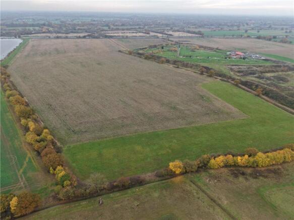
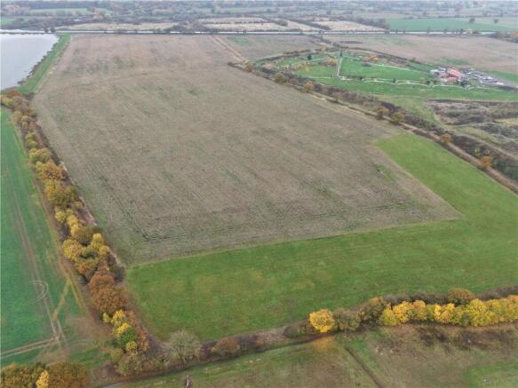
The land at West Cowick is situated approximately 2 miles to the south of the village of West Cowick and 9 miles to the west of the town of Goole in the East Riding of Yorkshire.
Access to junction 36 of the M62 is situated approximately 7 miles to the west of the land.
Land
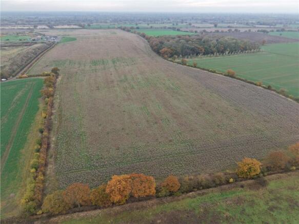
A productive block of agricultural land extending in all to approximately 129.56 acres (52.43 hectares) available as a whole or in up to 2 lots.
The land is currently farmed within a combinable cropping rotation and is classed as being Grade 3 under the former MAFF Land Classification Series.
The underlying soil type is classed as being part of the Foggathorpe 2 soil series which is described as a slowly permeable stoneless clayey and fine loamy over clayey soil and suited to cereals and grassland with stock rearing.
The land benefits from a well-maintained drainage scheme and drainage rates are payable to Danvm Drainage Commissioners Internal Drainage Board (IDB).
The land is generally level and situated at approximately 5 metres above sea level.
Access to Lot 1 is taken directly from the public highway known as Carr Lane, over a private right of way as shaded brown on the sale plan.
Access to Lot 2 is taken directly from the public highway is taken directly from the minor public over a private right of way over Park Lane.
Method of Sale
The property is offered for sale by private treaty as a whole or in up to 2 lots. The vendors reserve the right to conclude the sale by any other means at their discretion.
If you have downloaded these particulars, please register your interest with the selling agent.
Tenure & Possession
The freehold of the Property is offered for sale with the benefit of vacant possession on completion.
Basic Payment Scheme
The land has been registered on the Rural Land Register and all de-linked payments will be retained by the Vendor.
Environmental Schemes
The land is included in a Countryside Stewardship (Mid-Tier) Scheme and a Sustainable Farming Incentive (SFI) Scheme.
Designations
The land is situated within a surface water Nitrate Vulnerable Zone (NVZ).
Ingoing
In addition to the purchase price, the Purchaser will be required to pay for any growing crops, including cultivations, seeds, fertilisers, sprays, lime, new leys and acts of husbandry at cost or market value (whichever is higher) where applicable.
Drainage
The land at West Cowick is drained with drainage rates payable to Danvm Drainage Commissioners Internal Drainage Board (IDB).
Wayleaves Easements & Rights of Way
The land is sold subject to and with the benefits of all rights of way, water drainage, water courses and other easements and rights of adjoining owners (if any) affecting the same and all existing and proposed wayleaves and other matters registered by any competent authority subject to statute.
Reservations
The Vendors reserve the right to shoot across Lot 1 from their retained property thereby enabling the effective operation of Park Lodge Shooting School.
Health & Safety
Parties are reminded to be as vigilant as possible when making an inspection and be aware of potential hazards including open ditches and drains. Parties viewing the property do so, entirely at their own risk.
VAT
Any prices quoted are exclusive of VAT. In the event that the sale of the property or any part of it or any right attached to it becomes a chargeable supply for the purposes of VAT, such tax will be payable in addition to the purchase price.
Sporting, Mineral and Timber Rights
The sporting rights are reserved from the sale in favour of the vendor. The mineral rights are included in so far as they are owned.
Local Authorities
East Riding of Yorkshire
(
Viewings
Parties are permitted to view the land on foot and during reasonable daylight hours.
Directions
Leave the M62 at junction 34 and travel north on the A19. At Eggborough roundabout take the 3rd exit towards the village of Snaith. Travel through the village of Snaith taking the 2nd exit at the Plough Inn roundabout before turing right signposted West Cowick. After approximately 0.5 mile turn right at the Ship Inn onto Finnley’s Lane. Continue over the M62 following Carr Lane and the land is situated at the end of Carr Lane marked with a Carter Jonas for sale board.
SAT NAV: DN14 9GH
What3Words
///relegate.uttering.joined
Brochures
ParticularsPark Lane, West Cowick, Goole, East Riding of Yorkshi, DN14

NEAREST STATIONS
Distances are straight line measurements from the centre of the postcode- Snaith Station1.7 miles
- Rawcliffe Station3.2 miles
- Thorne North Station4.3 miles

Notes
Disclaimer - Property reference HGT250040. The information displayed about this property comprises a property advertisement. Rightmove.co.uk makes no warranty as to the accuracy or completeness of the advertisement or any linked or associated information, and Rightmove has no control over the content. This property advertisement does not constitute property particulars. The information is provided and maintained by Carter Jonas Rural, Yorkshire. Please contact the selling agent or developer directly to obtain any information which may be available under the terms of The Energy Performance of Buildings (Certificates and Inspections) (England and Wales) Regulations 2007 or the Home Report if in relation to a residential property in Scotland.