Open Storage Land, ABP Port Of Ipswich, Wherstead Road , Ipswich , Suffolk , IP2 8NB
- SIZE AVAILABLE
94,961 sq ft
8,822 sq m
- SECTOR
Land to lease
Lease details
- Lease available date:
- Ask agent
Description
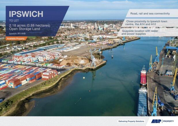
Space available: 2.18 acres (0.88 hectares) Open Storage Land.
- Strategically situated at the head of the River Orwell
- 12 miles from the open sea
- Within a short sailing time from the North Sea shipping lanes
- The major trunk roads A14 and A12 are both within easy reach
- Connections to the M25, M11 and the Port of Felixstowe
- Potential Uses: Industrial / Logistics / Warehousing / Distribution / Open storage / Port-related uses
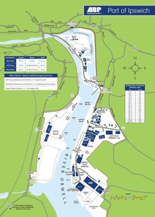
Situation
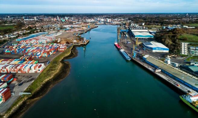
The Port of Ipswich is strategically situated at the head of the River Orwell, 12 miles from the open sea and within a short sailing time from the North Sea shipping lanes. The port also has an active rail line on the West Bank Terminal.
The Port offers occupiers the opportunity to benefit from close access to Ipswich town centre less than a mile away. The major trunk roads A14 and A12 are both within easy reach and provide connections to the M25, M11, and the Port of Felixstowe.
The Port of Ipswich 2.0 million tonnes of goods annually and has expertise in the handling of steel, forest products and bulk cargoes.
The docks can accept vessels of varying sizes:
Draught: up to 8.4m
Beam: no restrictions
Length: 155m
(ABP can provide separate handling services quotation on application).
Road
A14 J56 - 1.5 miles / 2.4km
A14/A12 - 3.8miles / 6.1km
Port of Felixstowe - 12.5 miles / 20km
M25 J28 - 55 miles / 88.67km
A1 / A14 J22 - 76.1 miles / 122.5km
Rail
Direct rail access and handling can be provided
Air
Stansted Airport - 48.9m / 78.7km
Sea
1,800m of berths across West Bank, Cliff Quay and the Wet Dock
Accommodation
Space available: 2.18 acres (0.88 hectares) Open Storage Land
Location
Ipswich is the administrative and county town of Suffolk with a resident population of 130,000 and a retail catchment population of approximately 300,000. The town lies on the River Orwell, approximately 70 miles north east of central London, 55 miles south east of Cambridge, 43 miles south of Norwich, and 18 miles north east of Colchester. Major roads in the area include the A12, which provides dual carriageway access to the A14, providing a principal link from the Port of Felixstowe (9 miles to the south east) to the East Midlands.
Business Rates
Rateable Value £69,500. All enquiries to Babergh District Council.
Planning
All enquiries to Babergh District Council.
Service Charge
A provision will be included for any lease for each tenant to pay a service charge, contributing to the costs of maintaining the common areas of the estate and providing on site security.
EPC
Not applicable.
VAT
VAT is applicable.
Open Storage Land, ABP Port Of Ipswich, Wherstead Road , Ipswich , Suffolk , IP2 8NB

NEAREST STATIONS
Distances are straight line measurements from the centre of the postcode- Ipswich Station0.8 miles
- Derby Road Station1.3 miles
- Westerfield Station2.7 miles
Notes
Disclaimer - Property reference 71664330LH. The information displayed about this property comprises a property advertisement. Rightmove.co.uk makes no warranty as to the accuracy or completeness of the advertisement or any linked or associated information, and Rightmove has no control over the content. This property advertisement does not constitute property particulars. The information is provided and maintained by Penn Commercial, Ipswich. Please contact the selling agent or developer directly to obtain any information which may be available under the terms of The Energy Performance of Buildings (Certificates and Inspections) (England and Wales) Regulations 2007 or the Home Report if in relation to a residential property in Scotland.
Map data ©OpenStreetMap contributors.