
Tullo Of Benholm Farm, Benholm, Montrose, Aberdeenshire, DD10
- PROPERTY TYPE
Land
- BEDROOMS
3
- BATHROOMS
1
- SIZE
20,808,176 sq ft
1,933,145 sq m
Key features
- Traditional 3 bedroom farmhouse
- Multi-function steel portal frame shed
- Around 477.69 acres (193.32 ha)
- Peaceful rural setting
Description
CLOSING DATE WEDNESDAY 18TH FEBRUARY 2026 AT 12 NOON
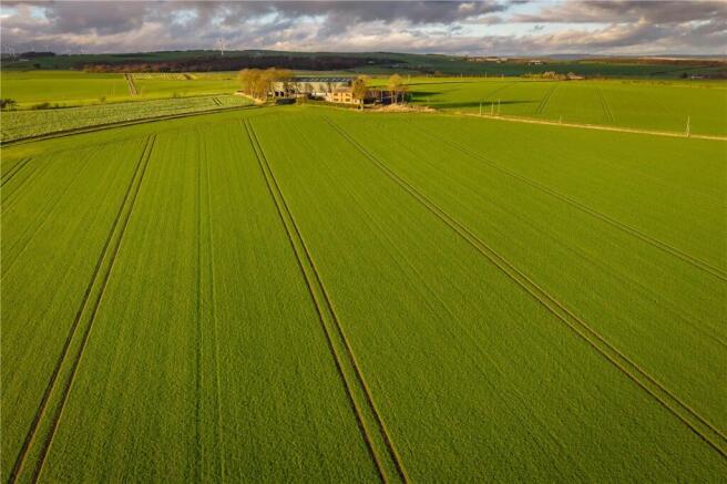
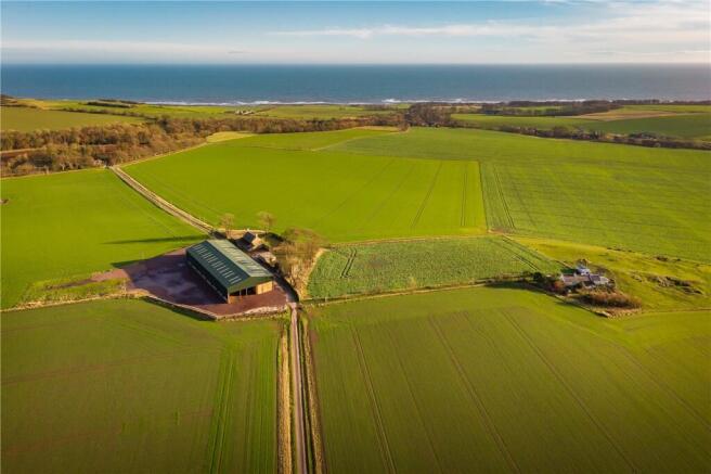
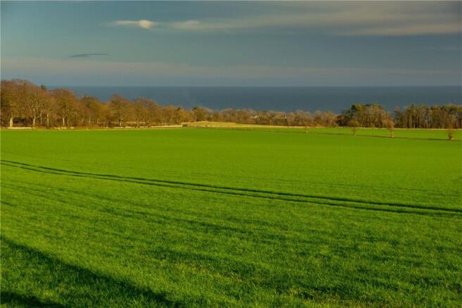
Tullo of Benholm Farm comprises a block of agricultural land extending to approximately 477.69 acres (193.32 ha), offering scope for a range of uses. According to the James Hutton Institute, the majority of the land is classified as Grade 3(1), and is registered for IACS purposes. The fields have traditionally been used for arable farming and has historically produced high yielding crops for cereals and oilseeds. The farmhouse enjoys a peaceful rural setting with open views towards the coast, creating an attractive living environment. The farm building is a modern steel-frame shed that provides extensive space and offers significant potential for a wide range of uses.
TULLO OF BENHOLM FARM
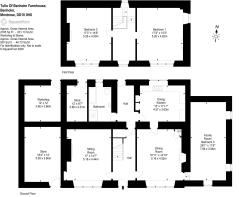
FARMHOUSE
Ground Floor: Kitchen, Dining Room, Sitting Room, Bathroom, General Store and another Sitting Room or Bedroom.
First Floor: Bedroom 1 and Bedroom 2.
An enclosed garden lies at the front of the property and the house enjoys a tranquil setting with views to the coast.
FARM BUILDINGS
Tullo Of Benholm Farm is well equipped; the Steel portal frame building lies in the centre of the farm with a sizeable yard area surrounding. The farm building comprises: General Purpose Shed (60m x 24m), constructed with a steel portal frame, box profile roof (non-drip) and cladding, concrete panel walls to 2 m, and a Type 1 floor.
LAND
Tullo of Benholm Farm extends to approximately 477.69 acres (193.32 ha), with access to the majority of the fields being directly from the public road network. The land is principally classified as Grade 3(1) with areas of 3(2) by the James Hutton Institute with the fields all benefiting from a south easterly aspect. The land rises from approximately 80-120 meters above sea level. The Dens to the south east of the farm formerly supported an exciting pheasant shoot with the land adjacent currently being in grass.
SITUATION
Tullo of Benholm Farm is situated in a sought-after area overlooking the coast, conveniently located 14 miles north of Montrose and 1.5 miles from the A92. The farm benefits from direct access off the public road network, with the land extending to 477.69 acres (193.32 ha). The land is surrounded primarily by agricultural land, sitting approximately 80-120 meters above sea level across the holding.
The land is suitable for a variety of agricultural uses, including the cultivation of high-value crops such as potatoes, peas, malting barley, and wheat. The area also benefits from a well established supply chain network to support these activities.
LOCATION
Tullo of Benholm is situated approximately 2.5 miles south-west of Inverbervie, 5 miles east of Laurencekirk, and 14 miles north of Montrose. The land is located in a much sought-after area and benefits from direct access onto the public road network.
EPC Rating = E
Brochures
ParticularsEnergy Performance Certificates
EPC Rating GraphTullo Of Benholm Farm, Benholm, Montrose, Aberdeenshire, DD10

NEAREST STATIONS
Distances are straight line measurements from the centre of the postcode- Laurencekirk Station5.0 miles


Notes
Disclaimer - Property reference ABN250154. The information displayed about this property comprises a property advertisement. Rightmove.co.uk makes no warranty as to the accuracy or completeness of the advertisement or any linked or associated information, and Rightmove has no control over the content. This property advertisement does not constitute property particulars. The information is provided and maintained by Galbraith, Aberdeen. Please contact the selling agent or developer directly to obtain any information which may be available under the terms of The Energy Performance of Buildings (Certificates and Inspections) (England and Wales) Regulations 2007 or the Home Report if in relation to a residential property in Scotland.
Map data ©OpenStreetMap contributors.