
Amenity Land & Woodland At Lindale, Lindale, Grange-Over-Sands, Cumbria
- PROPERTY TYPE
Land
- SIZE
351,965 sq ft
32,699 sq m
Key features
- Two enclosures of amenity land and woodland located on the edge of the village of Lindale.
- Both lots benefit from a fine selection of both recently planted and mature hardwood trees throughout.
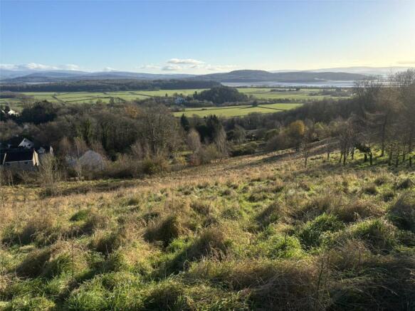
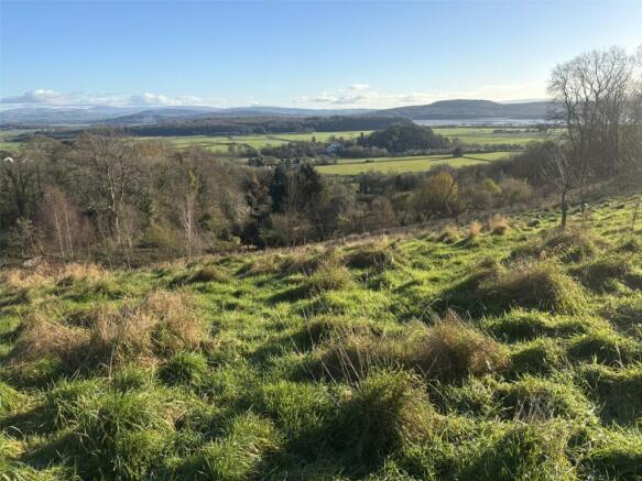
- Occupies an elevated location, providing excellent southeasterly views toward Morecambe Bay.
- Separate access provided to both lots.
- Of interest to local land and property owners, investors and those with environmental interests.
- Positioned on the periphery of the Lake District National Park [UNESCO World Heritage Site].
Description
To be offered for sale in two lots, each with separate access arrangements.
Lot 1 – 4.14 acres (1.68 hectares)
Lot 2 – 3.94 acres (1.59 hectares)
Lot 1
Extending in all to approximately 4.14 acres (1.68 hectares). As Shown Shaded Red on the Sale Plan
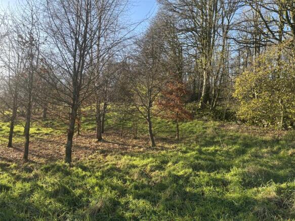
Lot 1 comprises a delightful parcel of amenity land and woodland, with an excellent variety of hardwood trees, of varying ages.
An enclosure of mature hardwoods forms the enclosure’s westerly boundary. The present owners have undertaken a program of tree planting works across the remainder of the parcel, resulting in the successful establishment of several clusters of juvenile trees.
The land rises steeply in a westerly direction, away from the adjacent highways, to offer tremendous views over Lindale and towards Morecambe Bay.
Boundaries comprise a mixture of post/ wire fences, mature hedgerows and dry stone walls. Prospective purchasers should note that the northerly and easterly boundaries present on the ground do not represent the boundaries of the land’s registered title. Reference should be made to the sale plan appended to these particulars of sale, which details the extent of the registered title, edged red.
Access to Lot 2 is provided off an unnamed public highway and across the area hatched yellow on the sale plan.
Lot 2
Lot 2 forms the southernmost of the parcels offered for sale, extending in all to circa 3.94 acres (1.59 hectares). As Shown Shaded Blue on the Sale Plan
To supplement the historic, mature trees and ornamental shrubs present across the holding, the parcel has been planted with a variety of hardwood tree species in recent years.
Boundaries comprise a mix of dry stone walls (with top wire), mature hedgerows and post/ wire fences. With the exception of the northerly fence line (adjacent to Lot 1), all boundaries appear to be in fair order.
Access to Lot 2 is provide directly off Windermere Road and across the section of land dashed purple on the sale plan.
Directions
Heading west along the A590 (Lindale Bypass) from Meathop Roundabout, take the exit signposted ‘Lindale B5271’. Continue for approximately 0.2 miles and turn right onto Tower View. Continue along this road, through the village, for a further 0.3 miles; the land is located on the left hand side and marked by the selling agent’s boards.
Location
The amenity land and woodland lies on the southern edge of the delightful village of Lindale, just 2 miles north of Grange-over-Sands and 12 miles south of Kendal, in the county of Cumbria.
What3Words: modules.lifetimes.replenish
Grid Reference: SD
Services
Services
It is understood that the land does benefit from mains water supplies, albeit such connections have not been utilised by the vendors during their ownership.
Auction General
General Information and Stipulations
The following Stipulations where applicable shall be deemed as Special Conditions of Sale. In the event of any variance between the Stipulations and the Special Conditions of Sale then the latter will prevail. Purchasers will also be deemed to have had full notice of the Stipulations and the Special Conditions of Sale and the same will not be read out at the time of sale. The Special Conditions of Sale may be inspected at the Auctioneer’s Offices and also the offices of the Seller’s Solicitors FOURTEEN days prior to the sale.
N.B Prospective purchasers are requested to contact the Seller’s Solicitors to discuss legal matters pertinent to the Sale Contract and documentation.
Solicitors
Renshaws Solicitors,28A Finkle Street, Kendal, Cumbria, LA9 4AB. Tel No: .
Tenure
Freehold.
Vacant Possession upon completion.
Method of Sale
The lots will be offered for sale in two lots as described in these particulars of sale. The Auctioneer reserves the right to amalgamate the Lots at the time of sale.
Completion
The date fixed for completion is 7TH APRIL 2026 or earlier by mutual agreement.
Sale Plan
The Sales Plan has been prepared by the Auctioneers for the convenience of prospective purchasers. They are deemed to be correct with any error, omission or misstatement shall not affect the sale. The purchasers must satisfy themselves as to its accuracy.
Environmental Stewardship Scheme
The land is not subject to any Environmental Stewardship Schemes
Wayleaves and Easements
The properties are sold subject to and with the benefit of any existing easements, wayleaves and rights of way. The sale is subject to all the existing rights of way, drainage, light, air support and other easements and quasi-easements and outgoings whether mentioned in these particulars or not.
Local Authority
Westmorland and Furness Council. Tel No: .
Boundaries
The ownership and maintenance responsibilities of the boundaries are indicated with the “T” marks on the sale plan. Where no “T” marks are shown, the responsibilities are unknown.
Note – the boundary which separates Lot 1 and Lot 2 is not presently stockproof. The responsibility of reinstating this boundary, together with future maintenance, will fall on the successful purchaser of Lot 1, should the lots sell separately.
It will be incumbent for the purchaser of Lot 1 to reinstate the abovementioned boundary within 3 months from the completion date.
Viewing
The land can be inspected at anytime by prospective buyers, provided a copy of these particulars are in their possession. All access is taken at your own risk. Tel No: , Option 3.
Money Laundering Regulations 2017
We are required by legislation to undertake checks on any potential purchaser prior to accepting their bid. Any interested party should either call into our Staveley Office with photographic ID, i.e., passport/driving licence and proof of address i.e., Council Tax/utility bill for copying prior to the auction or present copies at the Auctioneer’s desk prior to the commencement of the sale.
Brochures
ParticularsAmenity Land & Woodland At Lindale, Lindale, Grange-Over-Sands, Cumbria

NEAREST STATIONS
Distances are straight line measurements from the centre of the postcode- Grange-over-Sands Station1.3 miles
- Kents Bank Station2.9 miles
- Arnside Station3.1 miles


Notes
Disclaimer - Property reference KEN250119. The information displayed about this property comprises a property advertisement. Rightmove.co.uk makes no warranty as to the accuracy or completeness of the advertisement or any linked or associated information, and Rightmove has no control over the content. This property advertisement does not constitute property particulars. The information is provided and maintained by H&H Land & Estates, Penrith. Please contact the selling agent or developer directly to obtain any information which may be available under the terms of The Energy Performance of Buildings (Certificates and Inspections) (England and Wales) Regulations 2007 or the Home Report if in relation to a residential property in Scotland.
Auction Fees: The purchase of this property may include associated fees not listed here, as it is to be sold via auction. To find out more about the fees associated with this property please call H&H Land & Estates, Penrith on 01768 800790.
*Guide Price: An indication of a seller's minimum expectation at auction and given as a “Guide Price” or a range of “Guide Prices”. This is not necessarily the figure a property will sell for and is subject to change prior to the auction.
Reserve Price: Each auction property will be subject to a “Reserve Price” below which the property cannot be sold at auction. Normally the “Reserve Price” will be set within the range of “Guide Prices” or no more than 10% above a single “Guide Price.”
Map data ©OpenStreetMap contributors.