
Land for sale
Land off Pasture Lane, Hose, Melton Mowbray
- PROPERTY TYPE
Land
- SIZE
426,452 sq ft
39,619 sq m
Description
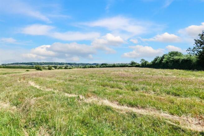
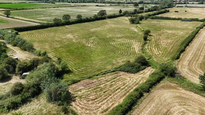
Description - An exciting opportunity to purchase approximately 9.79 Acres (3.96 ha) of pastureland to the south of the village of Hose, Leicestershire. The land is split into three main enclosures and is made up of gently undulating pasture. The land falls to the centre of the enclosures where a small steam / watercourse runs through. A bridge allows for access to the other land parcels on the other side if the stream. The property is surrounded by a mixture of mature hedging and timber post and wire fencing. A small open fronted timber storage building is located within the northernmost enclosure. A 40ft Shipping container is available via seperate negotiation.
Location - The land is located to the south of the small rural village of Hose, Leicestershire, and is located within the Vale of Belvoir on the Nottinghamshire / Leicestershire boarder. Hose benefits from a small range of public facilities including a village primary school, Public House and community hall. The market town of Melton Mowbray is located approiximatley 8 miles to the south where a compehensive range of public services are available along with mainline road and rail connections.
What 3 Words Location: ///shuttle.intention.bedrooms
Method Of Sale - The land is initially offered for sale via private treaty. The vendor reserves the right to conclude the sale by alternative method if required.
Tenure - The land is held freehold with vacant possession available upon completion.
Local Authority - Melton Borough Council
Burton Street,
Melton Mowbray,
Leicestershire,
LE13 1GH
Services - The land does not benefit from connection to any mains services.
Viewings - Strictly by appointment only.
Development Uplift Clause - A development uplift clause of 20% for a 20 year period will apply to the land and relates to any increase in value arising from the grant of planning permission (excluding agricultural and equestrian use) and is payable to the vendor.
Rights Of Way / Easements / Wayleaves - The land is crossed by public footpath F43
Access - The land is accessed directly off Pasture Lane.
Vat - In the event that any part of the holding is subject to VAT, this will be payable by the Purchaser in addition to the Purchase Price.
Land Registry - The land is registered with the Land Registry. Title Number: LT455182
Sporting / Timber / Mineral Rights - Where owned, the sporting, timber and mineral rights are included within the sale
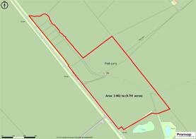
Plan - The plan and red lines has been provided for identification purposes only.
Rates And Outgoings - The property is sold subject to any other rates and outgoings which the purchaser will be liable for.
Environmental Schemes - The land is not subject to any current environmental schemes.
Further Information - If you require any further information, please contact:
Edward Higgins BSc (Hons) MRICS
Andrew Granger & Company, 44-46 Forest Road, Loughborough, LE11 3NP
Tel:
Email: edward.
Brochures
Land off Pasture Lane, Hose, Melton MowbrayLand off Pasture Lane, Hose, Melton Mowbray

NEAREST STATIONS
Distances are straight line measurements from the centre of the postcode- Melton Mowbray Station6.1 miles
About Andrew Granger & Co Rural, Land and Development, Loughborough
7-8 Bedford Square, Loughborough, LE11 2TP
Notes
Disclaimer - Property reference 34022108. The information displayed about this property comprises a property advertisement. Rightmove.co.uk makes no warranty as to the accuracy or completeness of the advertisement or any linked or associated information, and Rightmove has no control over the content. This property advertisement does not constitute property particulars. The information is provided and maintained by Andrew Granger & Co Rural, Land and Development, Loughborough. Please contact the selling agent or developer directly to obtain any information which may be available under the terms of The Energy Performance of Buildings (Certificates and Inspections) (England and Wales) Regulations 2007 or the Home Report if in relation to a residential property in Scotland.
Map data ©OpenStreetMap contributors.