House for sale
Dol Y Bont, Aberystwyth

- PROPERTY TYPE
House
- SIZE
Ask agent
- TENUREDescribes how you own a property. There are different types of tenure - freehold, leasehold, and commonhold.Read more about tenure in our glossary page.
Freehold
Key features
- TO BE SOLD BY PUBLIC AUCTION
- 94 Acres of land
- Derelict farmhouse and outbuildings
- Situated in a favoured agricultural area on the early growing belt
Description
For Sale By Public Auction - In a favoured agricultural area on the early growing coastal belt 94 acres of land together with abandoned farmhouse and traditional outbuildings known as
FRONGOCH
DOLYBONT
ABERYSTWYTH
CEREDIGION
SY24 5LY
Price Guide £750,000 To £800,000 -
Sole Selling Agents - Aled Ellis & Co Ltd, 16 Terrace Rd, Aberystwyth, Ceredigion, SY23 1NP. Tel – or email –
Method Of Sale - Frongoch is offered for sale by Public Auction on Friday 20th February 2026 at 2pm at The Aberystwyth Park Lodge Hotel (Llety Parc), Parc Y Llyn, Llanbadarn Fawr, Aberystwyth, SY23 3TZ.
On the fall of the hammer the purchaser must immediately pay 10% of the purchase price. Please take legal advise before attending the auction.
Money Laundering Regulations - Successful parties will be required to provide sufficient up to date identification to verify identity in compliance with the Money Laundering Regulations. For example: - Passport/ Photographic Driving licence and a current utility bill.
Solicitors - The solicitors acting are Humphrey, Roberts and Bott, 1 Alfred Place, Aberystwyth, Ceredigion, SY23 2BS. Tel – or email – . REF – WH.
To View - Frongoch can be viewed at any time. We advise that you proceed PART of the way with 4WD vehicle only. Please ensure that the gate is closed on departure.
Possession - Frongoch is sold with vacant possession. Completion is 28 days from the date of auction or earlier by arrangement.
Tenure - Freehold – Title No – CYM897898
Services - Private water source only.
Planning Matters - Prospective purchasers must make their own enquiries with Ceredigion County Council planning dept on or email -
Os Plan - We include with these particulars a copy of the IACS and PRO MAP plans for identification purposes. the extent of the land is highlighted in red on the Land Registry Plan - (Title No CYM897898)
Pro Map -
Rights, Eastments & Boundaries - Please refer to the contract of sale. There is both a public footpath and Bridleway through the homestead.
Directions - (OS Grid Ref: SN )
What3words – loudness.direct.ramp
From Aberystwyth proceed in a Northerly direction out of town on the A487 trunk road up Penglais Hill to Bow St. Proceed through Bow St before turning left at Rhydypennau (near the garage) on to the B4353 Borth Road (signposted). Proceed through the village of Llandre before turning right to Dolybont (immediately after the railway bridge). Continue through the village over the humpback bridge taking the fork right towards Taliesin. The track leading to Frongoch Land is on your right-hand side approx. ¼ mile further on than Henllys (the dairy farm) on the right-hand side.
Particulars Of Sale -
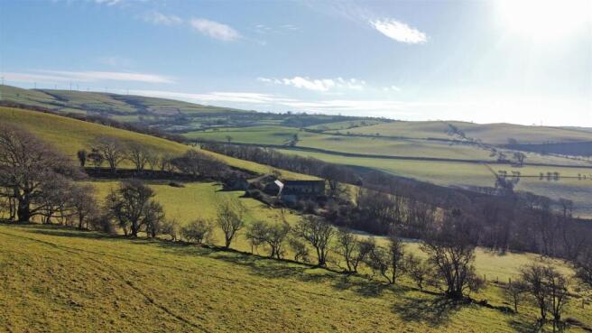
Location - Frongoch is approached off the Dolybont to Taliesin Road, a mile or so to the East of the village of Dolybont. Local amenities are available nearby at the villages of Borth and Bow Street. The university and market town of Aberystwyth is some 8 miles or so travelling distance to the South.
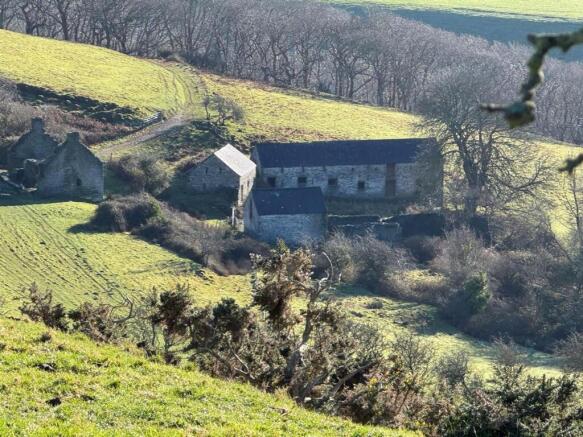
The Homestead - Please see attached photographs.
Access to the homestead is from the Dolybont to Taliesin Road. The historical access was from the southern boundary.
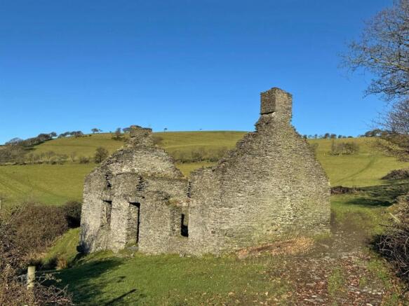
Abandoned Farmhouse -
Farm Outbuildings - The outbuildings comprise of – Traditional range/ former cowshed 60’ x 18’ approx. comprising of
Loosebox 1 – 23’2 x 17’5
Loosebox 2 – 12’1 x 17’5 with loft over
Loosebox 3 – 26’4 x 17’5
2 Cart-houses 19’ x 16’ with loft over with attached derelict outbuilding.
Further traditional building – see photographS
The Land - This useful parcel of land is mainly south facing with sheltered lower enclosures and natural water sources. Of the total area approximately 18 acres is non grazing land, the majority being woodland on the Southern boundary abutting the River Leri. The topography of the land is that of undulating sheep walks with more level enclosures towards the Northern boundary which rise to about 160 metres above sea level.
There are handling/ loading facilities just of the council-maintained road on the track leading to the farm.
Schedule Of Acreages - From the IACS
Brochures
Dol Y Bont, AberystwythBrochure- COUNCIL TAXA payment made to your local authority in order to pay for local services like schools, libraries, and refuse collection. The amount you pay depends on the value of the property.Read more about council Tax in our glossary page.
- Exempt
- PARKINGDetails of how and where vehicles can be parked, and any associated costs.Read more about parking in our glossary page.
- Yes
- GARDENA property has access to an outdoor space, which could be private or shared.
- Ask agent
- ACCESSIBILITYHow a property has been adapted to meet the needs of vulnerable or disabled individuals.Read more about accessibility in our glossary page.
- Ask agent
Energy performance certificate - ask agent
Dol Y Bont, Aberystwyth

Add an important place to see how long it'd take to get there from our property listings.
__mins driving to your place
Get an instant, personalised result:
- Show sellers you’re serious
- Secure viewings faster with agents
- No impact on your credit score


Your mortgage
Notes
Staying secure when looking for property
Ensure you're up to date with our latest advice on how to avoid fraud or scams when looking for property online.
Visit our security centre to find out moreDisclaimer - Property reference 34417886. The information displayed about this property comprises a property advertisement. Rightmove.co.uk makes no warranty as to the accuracy or completeness of the advertisement or any linked or associated information, and Rightmove has no control over the content. This property advertisement does not constitute property particulars. The information is provided and maintained by Aled Ellis & Co Ltd, Aberystwyth. Please contact the selling agent or developer directly to obtain any information which may be available under the terms of The Energy Performance of Buildings (Certificates and Inspections) (England and Wales) Regulations 2007 or the Home Report if in relation to a residential property in Scotland.
Auction Fees: The purchase of this property may include associated fees not listed here, as it is to be sold via auction. To find out more about the fees associated with this property please call Aled Ellis & Co Ltd, Aberystwyth on 01970 600506.
*Guide Price: An indication of a seller's minimum expectation at auction and given as a “Guide Price” or a range of “Guide Prices”. This is not necessarily the figure a property will sell for and is subject to change prior to the auction.
Reserve Price: Each auction property will be subject to a “Reserve Price” below which the property cannot be sold at auction. Normally the “Reserve Price” will be set within the range of “Guide Prices” or no more than 10% above a single “Guide Price.”
*This is the average speed from the provider with the fastest broadband package available at this postcode. The average speed displayed is based on the download speeds of at least 50% of customers at peak time (8pm to 10pm). Fibre/cable services at the postcode are subject to availability and may differ between properties within a postcode. Speeds can be affected by a range of technical and environmental factors. The speed at the property may be lower than that listed above. You can check the estimated speed and confirm availability to a property prior to purchasing on the broadband provider's website. Providers may increase charges. The information is provided and maintained by Decision Technologies Limited. **This is indicative only and based on a 2-person household with multiple devices and simultaneous usage. Broadband performance is affected by multiple factors including number of occupants and devices, simultaneous usage, router range etc. For more information speak to your broadband provider.
Map data ©OpenStreetMap contributors.