
Black Firs Lane, Congleton
- PROPERTY TYPE
Land
- SIZE
Ask agent
Key features
- RARE OPPORTUNITY FOR BESPOKE EXECUTIVE HOMES IN EXCLUSIVE SETTING
- PRIME LOW-DENSITY DEVELOPMENT SITE IN PRESTIGIOUS CHESHIRE LOCATION
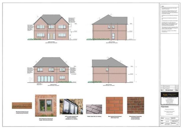
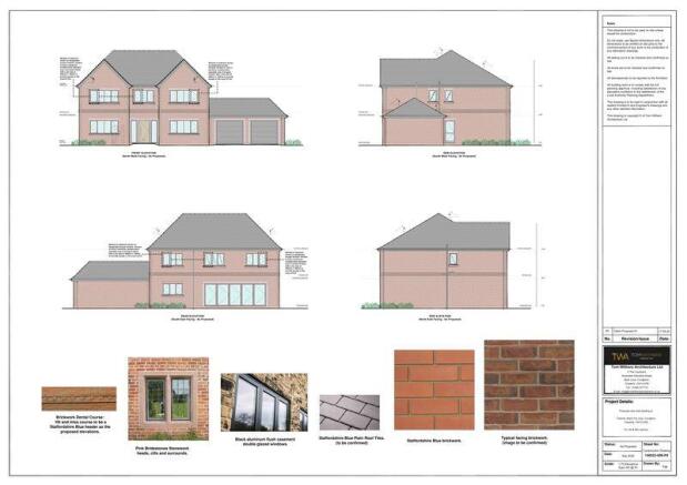
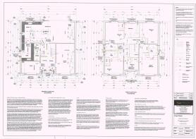
- FULL PLANNING CONSENT FOR THREE EXECUTIVE FIVE-BEDROOM HOMES
- READY-TO-DEVELOP SCHEME WITH REDUCED PLANNING RISK
- ALL PLANNING CONDITIONS RELEASED OTHER THAN LANDSCAPING (TO BE AGREED ONCE CONSTRUCTION COMMENCES)
- UNITED UTILITIES S106 APPROVAL
- APPROVED DRAINAGE DESIGN
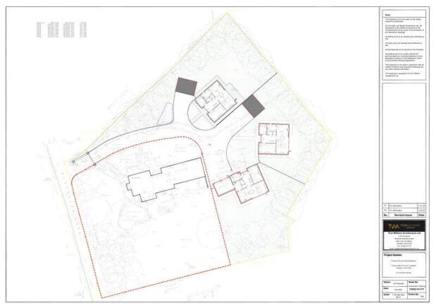
- APPROXIMATELY 0.953 ACRES WITH SHARED PRIVATE DRIVEWAY
- HIGH-VALUE AREA WITH CONSISTENTLY STRONG MARKET DEMAND
- EXCELLENT CONNECTIVITY TO M6, MANCHESTER AIRPORT & LINK ROAD
Description
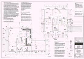
An exceptional opportunity to acquire a ready-to-develop residential site in one of Congleton’s most prestigious and consistently high-value locations. The site extends to approximately 3,859 sq. m (0.953 acres / 0.385 hectares), including a shared private driveway, and benefits from full planning permission for the construction of three substantial five-bedroom detached executive dwellings, each of approximately 3,000 sq. ft. Under planning reference number ………See link to Cheshire East Planning Portal - Cheshire East | pa.cheshireeast.gov.uk | Application | 277401
This consented scheme offers an ideal scale for a high-end, low-density executive development, perfectly suited to the current demand for large family homes in prime Cheshire locations. The setting, combined with the size and specification of the approved dwellings, positions the development strongly within the upper end of the local residential market, where values have historically proven resilient.
The site occupies a highly desirable and established address, characterised by wide, tree-lined avenues and individually designed detached homes set back behind mature gardens. Its position on the western fringe of Congleton, directly bordering open countryside, provides the semi-rural environment increasingly sought after by today’s purchasers, while retaining immediate access to the town’s amenities.
From a development perspective, the location offers excellent fundamentals: close proximity to high-performing schools, nearby retail at West Heath Shopping Centre, and strong regional connectivity. The property enjoys swift access to the M6 motorway (approx. 6 miles) and is well placed for Manchester Airport (approx. 17 miles). The completion of the Congleton Link Road in 2021, connecting the A534 and A536, has further enhanced accessibility, commuter appeal and long-term growth prospects.
With full planning consent already secured, the site allows a purchaser to move directly toward detailed design, discharge of conditions and build-out, reducing planning risk and holding time. The scale and nature of the scheme make it attractive to both regional housebuilders and private developers seeking a premium product in a proven residential market.
This is a rare opportunity to deliver a small collection of bespoke executive homes in one of Congleton’s most exclusive settings, where supply is extremely limited and end-user demand remains consistently strong.
Brochures
Property BrochureFull DetailsBlack Firs Lane, Congleton

NEAREST STATIONS
Distances are straight line measurements from the centre of the postcode- Congleton Station2.5 miles
- Holmes Chapel Station4.7 miles
- Goostrey Station4.8 miles


Notes
Disclaimer - Property reference 12238845. The information displayed about this property comprises a property advertisement. Rightmove.co.uk makes no warranty as to the accuracy or completeness of the advertisement or any linked or associated information, and Rightmove has no control over the content. This property advertisement does not constitute property particulars. The information is provided and maintained by Timothy A Brown, Congleton. Please contact the selling agent or developer directly to obtain any information which may be available under the terms of The Energy Performance of Buildings (Certificates and Inspections) (England and Wales) Regulations 2007 or the Home Report if in relation to a residential property in Scotland.