The Langridge, Land Off Bardwell Road, Ixworth, Bury St Edmunds, Suffolk, IP31 2HB
- SIZE AVAILABLE
916,008 sq ft
85,100 sq m
- SECTOR
Land for sale
Key features
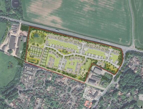
- Outline Planning Permission for up to 160 Dwellings
- 8.51 Hectares (21.02 acres)
- FOR SALE BY INFORMAL TENDER
- OFFERS TO BE RECEIVED BY 10TH APRIL 2026
Description
8.51 Hectares (21.02 acres)
FOR SALE BY INFORMAL TENDER
OFFERS TO BE RECEIVED BY 10TH APRIL 2026
Detailed Description
THE SITE
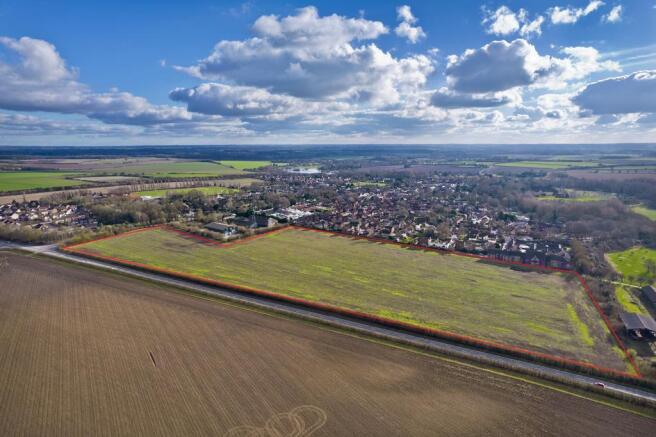
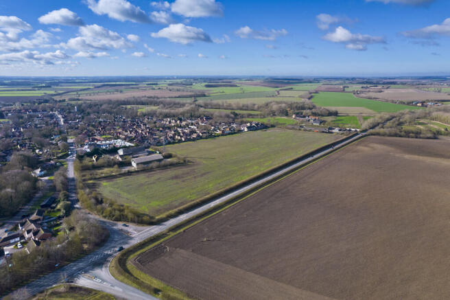
The land extends to approximately 8.51 hectares (21.02 acres) of broadly level, currently cultivated arable land, situated to the south of the A1088 and west of Bardwell Road, on the northern edge of the village of Ixworth. The site is regular in shape and fronts both Bardwell Road and the A1088, which are links roads to the A143 providing access to the cathedral town of Bury St Edmunds.
LOCATION
Ixworth is a sought after semi-rural village offering a range of local amenities including shops, public houses, restaurants, schools and other community facilities, such as the doctor's surgery and pharmacy, all within easy walking distance. It benefits from good transport links providing road access to Bury St Edmunds, Thetford, Diss and Stowmarket.
Railway stations at Thurston, Bury St Edmunds, Diss and Stowmarket provide frequent services to London Liverpool Street, Norwich and Cambridge ensuring strong commuter links to the capital and regional cities. The combination of local facilities and connectivity makes Ixworth an attractive location for residential development.
PLANNING BACKGROUND
The site received outline planning permission on the 24th February 2026 with a S106 Agreement signed and completed. (LPA Ref. DC/25/0370/OUT). This application is for up to 160 dwellings, including market and affordable homes, flats and self-build plots. All matters are reserved except for access, which is approved onto Bardwell Road. The scheme also provides for provision of open space, landscaping, sustainable drainage and associated infrastructure and works.
The scheme recognises the rural setting of the site being situated on the edge of the village. The extensive landscaping and open spaces allows for a high-quality development, whilst delivering all BNG on site. This will help create and deliver a desirable environment for the residents with strong market appeal and house sales pricing.
S106, COMMUNITY INFRASTRUCTURE LEVY (CIL), SELF-BUILD & HOUSING MIX
The S106 Agreement includes contributions totalling £2,249,329.33, together with 40% affordable housing (67% rented and 33% shared ownership), alongside provision of self-build plots. There is no CIL applicable to the scheme.
ACCESS
The site has approved access from Bardwell Road.
RIGHTS OF WAY
There are currently no public rights of way on the subject property. However, as part of the outline planning permission, the provision of a bridleway is required which will link the new access road, within the development site, to the Langridge Track and then through retained land, 'The Front Meadow', linking the site to Thetford Road. Additionally a public footpath is then to be created around 'The Cricket Meadow' linking Thetford Road to the existing bridleway (Ixworth Bridleway 001) situated to the south. Further information and plans can be found in the data room.
OVERAGE
Offers are required to include a provision for overage which is expected to be linked to coverage, GDV, and/or unit numbers, as well as an S.106 contribution or affordable housing reductions. Proposals for overage are invited and should be set out within the tender form.
SERVICES
Electricity, water, drainage, gas and telecoms are available in the vicinity of the site.
Further utility information and costs are included in the data room.
BOUNDARIES
The boundary to north of the property comprises a mature hedge fronting the A1088. The western boundary is a post and two strand barbed wire fence. The southern boundary is formed by the rear boundary fences of the adjacent residential properties. The eastern boundary and around the existing commercial and agricultural buildings has been staked.
RESERVED RIGHTS
The Seller is to retain rights:
(a) to install service media (the precise location and connection points for such service media to be agreed between the parties (acting reasonably) and an estate road with appropriate footpaths through a road corridor of a width of no less than 12 meters which is to run from the Estate Road to be constructed on the Property to the boundary of the Retained Land. Further details can be found in the Data Room.
(b) rights to connect into any Service Media on the Property
(c) rights of way over the estate roads and footpaths constructed on the Property
(d) rights to lay Service Media along the Langridge and the adjoining verge on either side of the Langridge (insofar as the same is within the Property) together with all appurtenant rights to connect into, upgrade, maintain, repair, renew and use such Service Media once laid.
(e) in connection with the delivery of part of the highways works, the Developer shall put a sum equivalent to the agreed estimated cost of the works in a retention fund to be held by the Seller's Solicitor. Further details can be found in the Data Room.
LAND REGISTRY
The property is freehold and forms part of Land Registry Title Number SK315569.
METHOD OF SALE
The property is offered for sale by Informal Tender on the following Terms:
1. All offers must be received by 12 Noon on Friday 10th April 2026.
2. Offers must be sent to nicholas. or delivered to Brown & Co's Bury St Edmunds Office for the attention of Nicholas Staton. Please note, an acknowledgement will be sent in return and if this is not received, please make further contact to ensure receipt.
3. Offers must be submitted in the prescribed form. Copies of the form can be obtained from the data room.
4. No offer will be considered which is calculated only be reference to another offer.
5. The seller does not undertake to accept the highest or indeed any bid.
LOCAL AUTHORITY
The site falls within the jurisdiction of West Suffolk Council.
VAT
It is expected that the property will be elected for VAT. Offers should be submitted on the basis VAT will be payable on the purchase price, unless directed otherwise.
LEGAL COSTS
Each party will be responsible for their own costs.
DATA ROOM
A data room for the proposed development has been compiled. Please contact the selling agent for the details.
HEALTH AND SAFETY
Neither the seller nor the selling agents are responsible for the health and safety of those viewing the property and accordingly do so at their own risk.
WHAT 3 WORDS
///habit.cups.startles.
VIEWING
Viewings are strictly by appointment only through Brown & Co.
SELLING AGENTS
Nicholas Staton & Simon Gilbey
E: nicholas. | simon.
T: |
Brochures
The Langridge, Land Off Bardwell Road, Ixworth, Bury St Edmunds, Suffolk, IP31 2HB

NEAREST STATIONS
Distances are straight line measurements from the centre of the postcode- Thurston Station3.7 miles
- Elmswell Station5.6 miles
- Bury St. Edmunds Station6.0 miles
Notes
Disclaimer - Property reference 450764FH. The information displayed about this property comprises a property advertisement. Rightmove.co.uk makes no warranty as to the accuracy or completeness of the advertisement or any linked or associated information, and Rightmove has no control over the content. This property advertisement does not constitute property particulars. The information is provided and maintained by Brown & Co, Bury St Edmunds. Please contact the selling agent or developer directly to obtain any information which may be available under the terms of The Energy Performance of Buildings (Certificates and Inspections) (England and Wales) Regulations 2007 or the Home Report if in relation to a residential property in Scotland.