
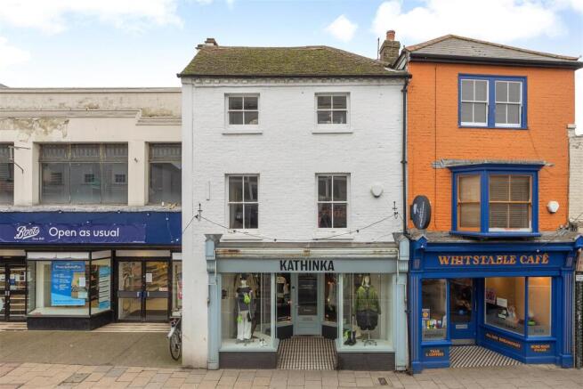

High Street, Whitstable
- PROPERTY TYPE
Retail Property (high street)
- SIZE
1,190 sq ft
111 sq m
Key features
- Freehold Commercial Premises
- Vacant Possession
- Substantial Period Building
- Prominent Trading Position with High Footfall
- Arranged Over 3 Floors
- Sympathetically Renovated
- Wealth of Period Character
- Generous Retail Space
- 45ft (13.72m) Courtyard
- No Onward Chain
Description
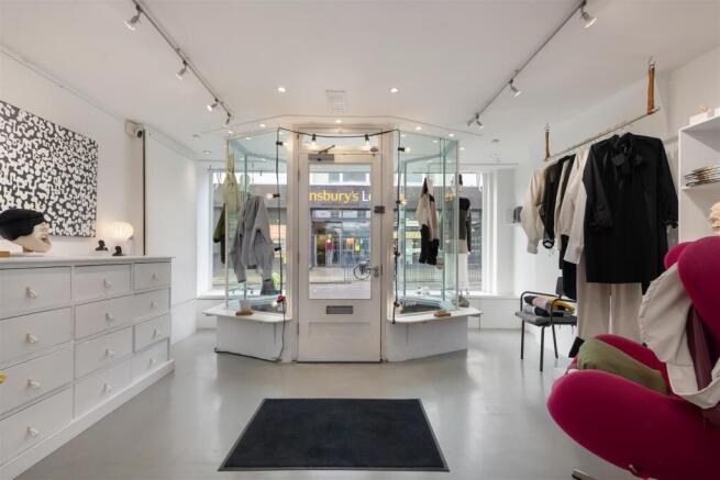
Being sold with no onward chain and vacant possession, the building has been sympathetically renovated to provide a modern space whilst retaining a wealth of period character. The building is set over three floors, with the ground floor arranged to provide a generous retail space with rear access to a courtyard, and the first and second floors comprise three further rooms, a smartly fitted kitchen/dining room, and a cloakroom.
Outside, the courtyard extends to 45ft (13.72m), incorporating a large decked area spanning the length of the courtyard.
The upper floors are thought suitable for residential redevelopment, with pedestrian access to the rear of the building via Victoria Mews (subject to obtaining all necessary consents and approvals being obtained).
The building suits a variety of businesses under use Class E. Planning permission was previously granted (now expired) under reference CA/21/00489 for three, two, and single-storey rear extensions with rear external staircase, following the demolition of an outbuilding and shed. Interested parties are advised to make their own enquiries relating to planning matters via Canterbury City Council;
Location - Whitstable High Street is a highly sought after location enviably positioned in the heart of town providing convenient access to a diverse range of local shops, highly regarded restaurants, the seafront, bus routes and recreational amenities and a short walk away from the town's fashionable Harbour Street. The property is located close to a busy pedestrian crossing and is within close proximity of Whitstable mainline railway station offering frequent services to London (Victoria) approximately 80mins. The high speed Javelin service provides access to London (St Pancras) with a journey time of approximately 73mins. The A299 is accessible providing a dual carriageway link to the M2/A2 giving access to the channel ports and connecting motorway network.
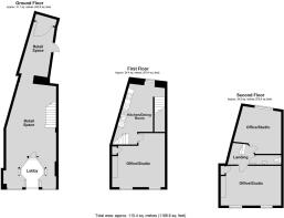
Accommodation - The accommodation and approximate measurements (taken at maximum points) are:
Ground Floor -
• Retail Space - 8.69m x 4.39m (28'6" x 14'5") -
• Retail Space (Rear) - 4.62m x 2.13m (15'2" x 7'0") -
First Floor -
• Display Room - 5.05m x 4.24m (16'7" x 13'11") -
• Display Room - 4.52m x 4.39m (14'10" x 14'5") -
Second Floor -
• Office/Studio - 5.03m x 3.30m (16'6" x 10'10") -
• Office/Studio - 3.73m x 3.57m (12'3" x 11'9") -
• Cloakroom - 2.11m x 0.61m (6'11 x 2'0") -
Outside -
• Courtyard - 13.72m x 3.66m (45'0" x 12'0") -
Rateable Values - According to the Valuation Office Agency website the property's ground floor current description is 'Shop and Premises' and the Rateable Value is currently £12,000.
The property's First and Second Floor current description is 'Office and Premises' and the Rateable Value is currently £5,300.
For more information please visit GOV.UK
Tenure - Freehold with vacant possession on completion.
Brochures
High Street, WhitstableHigh Street, Whitstable

NEAREST STATIONS
Distances are straight line measurements from the centre of the postcode- Whitstable Station0.4 miles
- Chestfield & Swalecliffe Station1.8 miles
- Herne Bay Station4.1 miles
About Christopher Hodgson, Whitstable
95-97 Tankerton Road, Whitstable, CT5 2AJ


Notes
Disclaimer - Property reference 34495051. The information displayed about this property comprises a property advertisement. Rightmove.co.uk makes no warranty as to the accuracy or completeness of the advertisement or any linked or associated information, and Rightmove has no control over the content. This property advertisement does not constitute property particulars. The information is provided and maintained by Christopher Hodgson, Whitstable. Please contact the selling agent or developer directly to obtain any information which may be available under the terms of The Energy Performance of Buildings (Certificates and Inspections) (England and Wales) Regulations 2007 or the Home Report if in relation to a residential property in Scotland.