

Canterbury Road, Charing
- PROPERTY TYPE
Plot
- SIZE
Ask agent
Key features
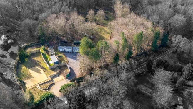
- Two Connected Plots On Separate Titles
- One Plot With Full Replacement Planning Permission For A Detached Dwelling
- Rarely Available Location Partly Surrounded By Woodland
- Approximate Plot Size Of 2.62 Acres
- Electric & Water Connections
- Private Ceptic Tank Drainage
- Two Static Caravan Homes On Site
- Concrete Foundations For Dwelling
- Viewing By Appointment Only
Description
The large site offers a rare opportunity for someone to build a detached bungalow with large gardens and extensive parking in an attractive woodland environment with mains electric and water services connected.
Charing enjoys an interesting mix of village shops, churches, post office collection and drop off service, primary school and doctor's surgery with pharmacy. Transport links are well supported with a mainline railway station in the village providing access to London Victoria and Ashford International Station with its high speed 37 minute service to London St Pancras. Junction 9 of the M20 Motorway is some 5 miles distant and Junction 8 some 8 miles.
Plot Size:
Approximately 2.62 Acres
(subject to confirmation)
Canterbury Road, Charing

NEAREST STATIONS
Distances are straight line measurements from the centre of the postcode- Charing Station1.6 miles
- Wye Station5.1 miles
- Pluckley Station5.4 miles


Notes
Disclaimer - Property reference SAD1713795. The information displayed about this property comprises a property advertisement. Rightmove.co.uk makes no warranty as to the accuracy or completeness of the advertisement or any linked or associated information, and Rightmove has no control over the content. This property advertisement does not constitute property particulars. The information is provided and maintained by Saddlers, Charing. Please contact the selling agent or developer directly to obtain any information which may be available under the terms of The Energy Performance of Buildings (Certificates and Inspections) (England and Wales) Regulations 2007 or the Home Report if in relation to a residential property in Scotland.