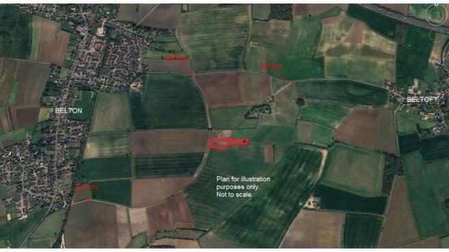

About 2.0 Acres Gurry Lane, Belton, Doncaster, DN9 1LY
- PROPERTY TYPE
Land
- SIZE
Ask agent
Key features
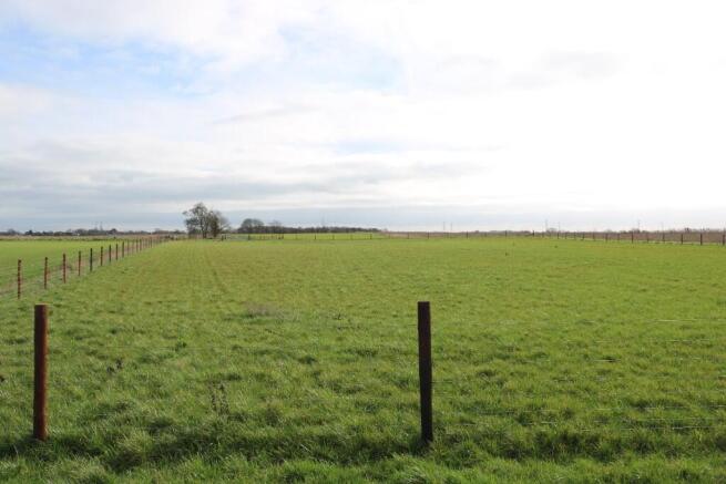
- The land is in two paddocks being divided by Gurry Lane. Each paddock includes:
- Modern post and stock proof wire facing
- Modern 14' metal gates
- Re-seeded and fertilised free draining sandy soils
- The larger western paddock extends to about 1.30 acres (0.5 hectare) and the smaller paddock to about 0.75 acres (0.30 hectare).
- On the Agricultural Land Classification Map the land is shown as being of Grade 2 quality.
Description
The land is located in attractive open countryside between Belton and Beltoft in an Area of Special Historic Landscape Interest. Situated about 500m to the south of Belton Road the land is only 2 miles from junction 2 of the M180 and 2 miles from the historic country town of Epworth.
Access to the land via an occupation lane is available from three routes. From the north there are two lanes from Belton Road (the road between Belton and Beltoft). From the south there is a lane leading from Belgrave Close (near the site of the former Steers Arms)
DESCRIPTION
The land is in two paddocks being divided by Gurry Lane. Each paddock includes:
* Modern post and stock proof wire facing
* Modern 14' metal gates
* Re-seeded and fertilised free draining sandy soils
The larger western paddock extends to about 1.30 acres (0.5 hectare) and the smaller paddock to about 0.75 acres (0.30 hectare).
On the Agricultural Land Classification Map the land is shown as being of Grade 2 quality.
WAYLEAVES, EASEMENTS AND RIGHTS OF WAY
The property is sold subject to and with the benefit of all the existing wayleaves, easements, covenants and rights of way, whether or not disclosed.
Access to the land is via unmade occupation lanes.
SPORTING AND MINERAL RIGHTS
All sporting and mineral rights are included in the sale so far as they are owned.
NITRATE VULNERABLE ZONE
The land is within a Nitrate Vulnerable Zone.
SERVICES
No services connected.
PLANS AND AREAS
Plans for illustration purposes only and not to scale.
Interested parties should satisfy themselves in regard to areas and boundaries.
TENURE
Freehold with vacant possession.
VIEWING
The land can be viewed during reasonable daylight hours with a copy of these particulars.
METHOD OF SALE
Private Treaty.
OUTGOINGS
Drainage rate is payable. Approximately £17 per year.
OVERAGE CLAUSE
The land is not being sold subject to an overage clause.
Brochures
Brochure 1About 2.0 Acres Gurry Lane, Belton, Doncaster, DN9 1LY

NEAREST STATIONS
Distances are straight line measurements from the centre of the postcode- Crowle Station2.8 miles
- Althorpe Station3.5 miles
Notes
Disclaimer - Property reference GURRYLANE. The information displayed about this property comprises a property advertisement. Rightmove.co.uk makes no warranty as to the accuracy or completeness of the advertisement or any linked or associated information, and Rightmove has no control over the content. This property advertisement does not constitute property particulars. The information is provided and maintained by Grice and Hunter, Epworth. Please contact the selling agent or developer directly to obtain any information which may be available under the terms of The Energy Performance of Buildings (Certificates and Inspections) (England and Wales) Regulations 2007 or the Home Report if in relation to a residential property in Scotland.