Land Nr Kirtling and Ashley
Business rates & charges may apply
- SIZE
Ask agent
- SECTOR
Farm land for sale
Description
The land is located to West, South and East of the village of Kirtling, which is approximately 6 miles to the South-East of Newmarket. The postcode for the middle of Kirtling Village is CB8 9PD.
The land near Ashley is located to the North-East of Ashley. The postcode for the village of Ashley is CB8 9DU
DESCRIPTION:
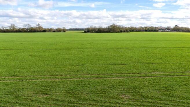
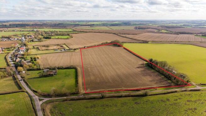
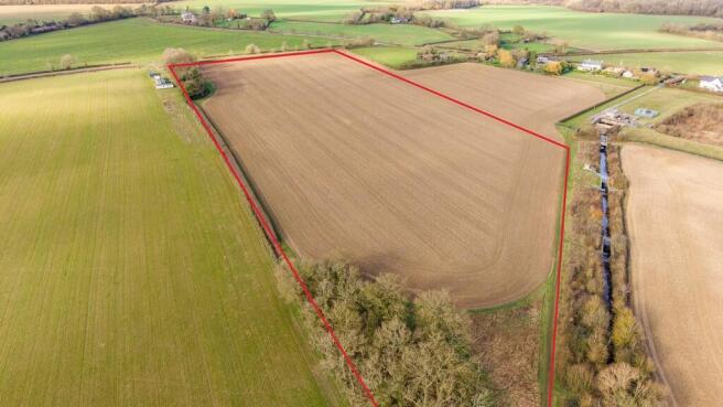
The offering includes Seven Lots of agricultural land which are available for sale as a whole, or individually. All Lots consist of bare agricultural land and four of the Lots include an area of trees/woodland.
LOT 1 - YELLOW - 6.56 HA / 16.21 AC.
Part of a single field, which gently slopes to the South. Accessed from Water Lane to the West. The ´What 3 Words´ location for the field entrance is ///gestures.poorly.january.
LOT 2 - GREEN - 18.48 HA / 45.66 AC.
A single field, which gently slopes to the South. Accessed from Woodditton Road to the North. The ´What 3 Words´ location for the field entrance is ///submerged.manage.wiring.
LOT 3 - TURQUOISE HATCHED - 17.71 HA / 43.76 AC.
A single field which slopes gently to the South. Accessed from Malting End to the North-West or from the North. The ´What 3 Words´ locations for the field entrances are ///surging.tradition.beard and ///lunching.comb.obstruction.
LOT 4 - BLUE - 42.65 HA / 105.39 AC.
Three fields and ´Deadwood´ Wood located along the West boundary. Accessed from Mill Road to the East. The ´What 3 Words´ locations for the field entrances are ///cherub.earpiece.trains and ///fronted.diet.funky
LOT 5 - RED - 23.74 HA / 58.66 AC.
Two fields and ´Jamies´ Wood, together with a thin strip of land leading Southwards towards Lot 6. Accessed from Mill Road to the West and Cowlinge Road to the North. The ´What 3 Words´ locations for the field entrances are ///goodbyes.unique.poetic and ///fluid.brilliant.busy.
LOT 6 - ORANGE - 21.22 HA / 52.43 AC.
A single field, which gently slopes to the East. Accessed from Bradley Road to the South-West. The ´What 3 Words´ location for the field entrance is ///sunblock.headings.gathering.
LOT 7 - PINK - 36.16 HA / 89.35 AC.
One field and part of a second field located to the East of the village of Ashley. The fields are accessed off the Dalham Road to the North. The ´What 3 Words´ location for the field entrance is ///contained.hurt.clocked and ///roughness.wage.falters.
FARM SCHEDULE AND PAST CROPPING
The land has latterly been farmed in an arable rotation - the back cropping is listed in the Sales Particulars.
LAND & SOILS CLASSIFICATION:
The land is classified as Grade 2 on the Land Classification Map of England & Wales. The land is classified by the Soil Survey of England and Wales as being part of the Hanslope Soil Series which is further described as "slowly permeable calcareous clayey soils. Some slowly permeable non-calcareous clayey soils. Landslips and associated irregular terrain locally" and capable of growing "winter cereals with some other arable crops".
NITRATE VULNERABLE ZONE
The land is within a Nitrate Vulnerable Zone and is subject to the usual restrictions. More details are available from the Environment Agency.
COUNTRYSIDE STEWARDSHIP & SFI SCHEMES:
The Land is not currently entered into a Countryside Steward Scheme. There are some rotational SFI Actions on the land - they will be moved at the earliest possible opportunity after completion of sale.
BASIC FARM PAYMENT (BPS):
The land is registered with the Rural Payments Agency and BPS was claimed previously. The seller will retain the Delinked Payment upon completion of the sale. Copies of the Rural Payments Agency Land Parcel Identification System (LPIS) Maps are available for inspection upon request from the Selling Agents.
LAND DRAINAGE:
There are some Land Drainage schemes in place, but no Land Drainage schemes have been completed in recent years.
UPLIFT PROVISION / OVERAGE CLAUSE:
Should the land be used for a non-agricultural purpose, whether or not Planning Permission is granted, an Overage Payment of 30% of the uplift in value will be payable to the Vendor or their successors in title. The clause will run for a period of 25 years. It is not envisaged that an Equine use would trigger the Uplift Provision.
CONTRACTS & QUOTAS:
There are no contracts or quotas included within the sale of the land.
DRAINAGE RATES:
There is an annual charge for the land drainage rates payable to the Environment Agency
TENANTRIGHT:
Depending on the time of year and the stage of crop establishment/land cultivations, tenantright will be charged in addition to the purchase price together with enhancement for growing crops.
DILAPIDATIONS:
There will be no allowance for dilapidations (if any).
HOLDOVER:
The Vendors reserve a Right of Holdover on the land plus appropriate rights of access.
TENURE & POSSESSION:
The tenure of the land is freehold. Possession of the land will be available upon completion subject to the rights of Holdover outlined.
WAYLEAVES, RIGHTS OF WAY & EASEMENTS:
The land will be sold subject to and offered with the benefit of all existing rights, including rights of way, whether public or private, light, support, drainage, water, electricity, and other rights, easements, quasi-easements and all wayleaves, whether referred to specifically in these particulars or not. It is the potential purchaser´s responsibility to investigate the availability of the above, this will be at the cost of the potential purchaser.
MINERALS, TIMBER & SPORTING RIGHTS:
The Mineral Timber & Sporting Rights are included in the sale as far as owned by the Seller.
SERVICES:
We are not aware of any services being connected to the land.
GUIDE PRICES:
A schedule of Guide Prices is available from the selling agent.
AREA MEASUREMENTS
All area measurements are provided for guidance purposes only. This is particularly relevant to Lots that split an existing Land Registry Title(s). Survey plans will be provided for all lots when sales are agreed (subject to contract) to confirm exact areas. This will enable final sale prices to be agreed.
METHOD OF SALE:
The land is offered for sale by Private Treaty. The Vendor reserves the right to conclude the sale by ´Best and Final´ offers.
VALUE ADDED TAX:
Should a sale of the land or any right attached to it become a chargeable supply for the purposes of VAT, such Tax will be payable by the Purchaser(s) in addition to the contract price. All Guide Prices quoted, or prices discussed are exclusive of VAT.
VIEWING:
All Lots border the public highway. Onsite viewings are by appointment with the selling Agents. All those entering the farm should take great care both for themselves, their property and any part of the farm or crops. It should be remembered that this is a working farm and neither the Vendor nor the Agents are responsible for any injury, accident or damage that occurs on the farm.
FURTHER INFORMATION:
If any further information is required regarding the land, please contact R. Longstaff and Co LLP´s Agricultural Department on , Ext 301.
LOCAL AUTHORITY
East Cambridge District Council, The Grange, Nutholt Lane, Ely CB7 4EE. Tel:
PARTICULARS CONTENT:
We make every effort to produce accurate and reliable details but if there are any particular points you would like to discuss prior to making your inspection, please do not hesitate to contact our office. The plans and areas reproduced in these Particulars are for identification purposes only and are NOT TO SCALE. Interested parties should carry out whatever investigations they wish to satisfy themselves as to the extent and area of the property offered and ensure they are fully aware of the boundaries and to confirm the areas involved should they so require. The information provided in these Particulars is for guidance purposes only.
Brochures
Land Nr Kirtling and Ashley

NEAREST STATIONS
Distances are straight line measurements from the centre of the postcode- Dullingham Station4.4 miles
- Newmarket Station4.7 miles
Notes
Disclaimer - Property reference 101505032771. The information displayed about this property comprises a property advertisement. Rightmove.co.uk makes no warranty as to the accuracy or completeness of the advertisement or any linked or associated information, and Rightmove has no control over the content. This property advertisement does not constitute property particulars. The information is provided and maintained by Longstaff Chartered Surveyors, Bourne. Please contact the selling agent or developer directly to obtain any information which may be available under the terms of The Energy Performance of Buildings (Certificates and Inspections) (England and Wales) Regulations 2007 or the Home Report if in relation to a residential property in Scotland.
Map data ©OpenStreetMap contributors.