
WL West and Sons Ltd
- SIZE
Ask agent
- SECTOR
Commercial development for sale
Key features
- For sale by private treaty - Offers Invited
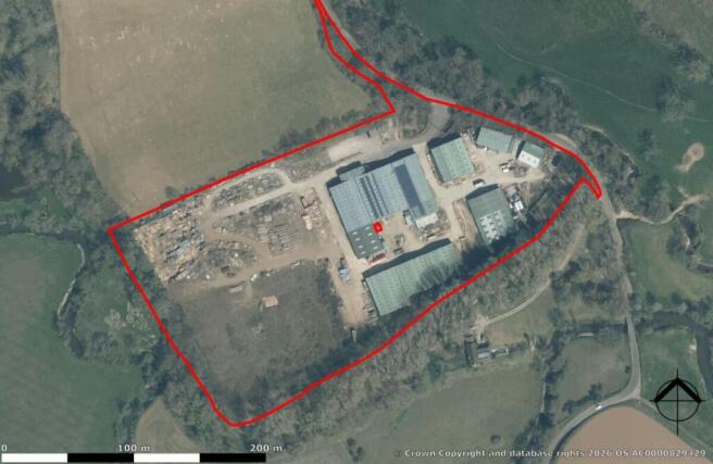
- Approx. 4.5 acres of development land (STP)
- Freehold site of approx. 12.36 acres
- Planning upside potential - Light ind (STP)
- HGV & large lorry access via Selham Road
- Strategic links to A272, A24 & A3
- Approx. 2.2 acres of hard-surfaced land
- Proposed 37-unit & BESS scheme
- Workshop, office & timber storage facilities
- Total income - flexible licences £94,673.06
Description
For sale by private treaty - Offers Invited
Approx. 4.5 acres of development land (STP)
Freehold site of approx. 12.36 acres
Planning upside potential - Light ind (STP)
HGV & large lorry access via Selham Road
Strategic links to A272, A24 & A3
Approx. 2.2 acres of hard-surfaced land
Proposed 37-unit & BESS scheme
Workshop, office & timber storage facilities
Total income - flexible licences £94,673.06
OVERVIEW
Strategic Development Potential
The property represents a rare and significant opportunity to acquire a substantial industrial footprint within the heart of the South Downs National Park. While currently operating as an established timber merchant, the site’s true value lies in its potential for redevelopment into a modern light industrial and logistics hub. A preliminary proposed site plan (available upon request) identifies the potential for 37 new commercial units alongside a dedicated BESS (Battery Energy Storage System) area. This intensification of use would transition the site from its traditional roots into a high-density employment zone, significantly enhancing
the local economy and asset value.
Logistics & Access
The site is specifically suited for light industrial pick-up and drop-off operations. It benefits from robust access capable of handling large HGVs and articulated lorries. Selham Road provides a direct and established route to the A272—the primary east-west artery for the county—providing efficient transit to the A24 and A3 corridors.
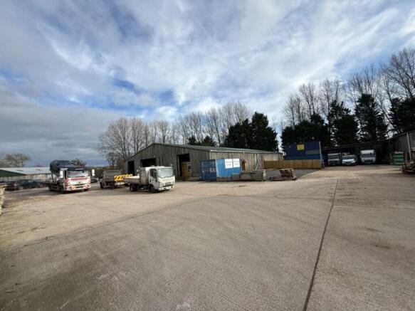
Current Description
The site currently comprises a mix of workshop, office, and specialist timber storage facilities. While these provide immediate operational capacity and an established income stream, they are viewed primarily as a footprint for future development. The site provides a unique “blank canvas” within a protected area where
new industrial allocations are exceptionally rare.
Timber Storage: Large-scale timber storage and processing sheds. The storage facilities are fitted with internal racking and provide opensided access with internal connectivity to the primary workshops, facilitating efficient site logistics.
Main Workshops: Workshop and storage facilities of steel portal frame construction with block elevations. These facilities feature clear eaves heights of 5.10m, multiple roller shutter doors, and integrated ground and first-floor office accommodation.
Ancillary Buildings: The site includes several additional buildings currently occupied by various commercial tenants, providing a mix of covered storage and specialised workspace.
The site provides a unique combination of vacant possession potential and an established multi-occupier income stream. The varying specifications of the buildings—from concretefloored workshops to traditional timber-slatted storage sheds—offer significant flexibility for industrial operators or investors.
Floor Areas
Description GIA (sq m) GIA (sq ft)
Main Workshop & Open Fronted Section 1,148.02 12,357
Workshop, Partitioned Sections & Offices 1,196.75 12,882
Open Fronted & Rough Surfaced Unit 907.73 9,771
Part Open Fronted & Rough Surfaced Unit 1,823.59 19,629
Ancillary Units (Combined) 1,625.39 17,496
Total Combined Area 6,701.48 72,135
Planning
The site benefits from established industrial use within a protected National Park setting. To the west of the existing workshops lies approximately 4.5 acres of surplus land which, in our opinion, offers significant potential for the construction of further light industrial units (subject to the necessary planning consents). Such intensification would represent a logical expansion of the current industrial footprint and provide a substantial uplift in site value. Please note that the property is to be sold as seen and is not subject to planning.
Tenure
Freehold either with full vacant possession or sold part income producing by way of existing license agreements.
Licence Agreements
A portion of the site is currently let via several flexible commercial licences, generating a combined gross annual income of £94,673.06. These agreements are scheduled to expire in approximately six months, providing a purchaser with the choice of maintaining the income stream or securing full vacant possession for their own operations.
EPC
To be confirmed once the assessments have been completed.
Flood Risk
Offers Invited
Offers are invited for the freehold interest.
Viewings
Please contact John Pye Property
WL West and Sons Ltd

NEAREST STATIONS
Distances are straight line measurements from the centre of the postcode- Pulborough Station7.1 miles
About John Pye Property, Nottingham
James Shipstone House, Radford Road, New Basford, Nottingham, NG7 7EANotes
Disclaimer - Property reference PROP1380. The information displayed about this property comprises a property advertisement. Rightmove.co.uk makes no warranty as to the accuracy or completeness of the advertisement or any linked or associated information, and Rightmove has no control over the content. This property advertisement does not constitute property particulars. The information is provided and maintained by John Pye Property, Nottingham. Please contact the selling agent or developer directly to obtain any information which may be available under the terms of The Energy Performance of Buildings (Certificates and Inspections) (England and Wales) Regulations 2007 or the Home Report if in relation to a residential property in Scotland.