
Whattall Farm Colemere, Ellesmere, Shropshire, SY12
- PROPERTY TYPE
Detached
- BEDROOMS
7
- BATHROOMS
2
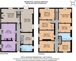
- SIZE
3,061 sq ft
284 sq m
- TENUREDescribes how you own a property. There are different types of tenure - freehold, leasehold, and commonhold.Read more about tenure in our glossary page.
Freehold
Key features
- DEADLINE FOR INITIAL OFFERS - 1st JUNE 2026 - Please contact the agents for further details.
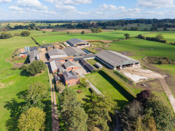
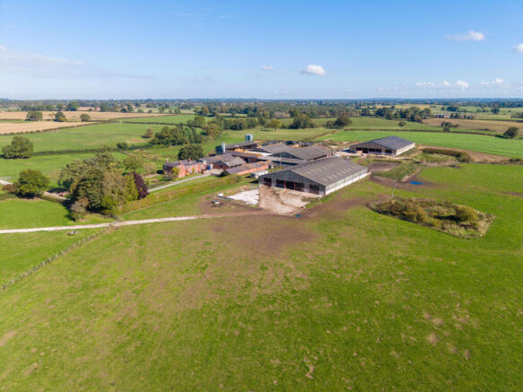
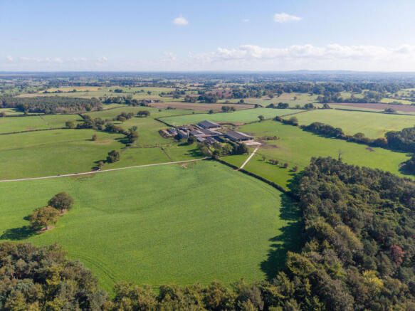
- Comprising approximately 826 acres of productive arable and grassland
- A useful farmstead at the end of a private drive, including a seven bedroom farmhouse
- A well managed yard, including a range of modern and traditional farm buildings
- Situated in a well regarded grass growing area, with a significant area of lighter and loamy soils, providing scope for arable, forage and root cropping enterprises
- Set around a significant central woodland, and Crose Mere lake, adding sporting and environmental value
- EPC Rating = D
Description
Description
Whattall Farm sits in the gently undulating North Shropshire countryside, a short distance south of the market town of Ellesmere, an area with a strong farming tradition. Offered for a sale after a significant period of private ownership, the farm is available with vacant possession from 29th September 2026, and subject to the tenancies and licenses described herein.
Currently operated as a mixed holding, at the heart of which has been a well-regarded Holstein herd, the farm provides a combination of lighter arable ground alongside good forage and grazing land which could lend itself to a range of enterprises.
Location
Situated just off the main A528 linking Ellesmere to Shrewsbury, the country around Whattall Farm is characterised by productive farmland, traditional villages, and a strong agricultural heritage. Gently rolling fields surround "Shropshire’s Lake District", the locally noted meres being the most obvious evidence that remains of the effect the last ice age had on the area.
The nearby market towns provide ample commercial, family and leisure amenities. Shrewsbury, as the nearest major town, provides a full range of leisure and service amenities, including the nearest livestock market and a range of machinery dealerships, alongside a noted range of independent shops and restaurants. Ellesmere offers lakeside walks, local stores, and a close knit community hub typical of country market towns.
For schools, the area is well served by Ellesmere College, Lakeland Academy, Packwood Haugh, Oswestry School and Moreton Hall – as well as a range of quality institutions near Shrewsbury and Chester.
The area remains well connected, via the road network to the M54 at Shrewsbury (for Birmingham and the south) and the A49 at Whitchurch, connecting Ellesmere to the north (Chester, Crewe, Liverpool and Manchester) as well as to the Welsh Marches and South Wales.
International airports are at Manchester (approximately 54 miles) and Birmingham (approximately 69 miles). Shrewsbury station provides national and regional rail connections, with Stafford station (40 miles) providing direct mainline services to London (from 77 minutes).
Square Footage: 3,061 sq ft
Acreage: 826 Acres
Additional Info
Council Tax Band: E
Services for Lot 1 only. Mains water, borehole, mains electric, oil fired heating and private drainage.
Photographs: 2025 and particulars February 2026.
Disclaimer: All journey times and distances are approximate
Brochures
Web Details- COUNCIL TAXA payment made to your local authority in order to pay for local services like schools, libraries, and refuse collection. The amount you pay depends on the value of the property.Read more about council Tax in our glossary page.
- Band: E
- PARKINGDetails of how and where vehicles can be parked, and any associated costs.Read more about parking in our glossary page.
- Yes
- GARDENA property has access to an outdoor space, which could be private or shared.
- Yes
- ACCESSIBILITYHow a property has been adapted to meet the needs of vulnerable or disabled individuals.Read more about accessibility in our glossary page.
- Ask agent
Whattall Farm Colemere, Ellesmere, Shropshire, SY12

Add an important place to see how long it'd take to get there from our property listings.
__mins driving to your place
Affordability

Get an instant, personalised result:
- Show sellers you’re serious
- Secure viewings faster with agents
- No impact on your credit score
Notes
Staying secure when looking for property
Ensure you're up to date with our latest advice on how to avoid fraud or scams when looking for property online.
Visit our security centre to find out moreDisclaimer - Property reference LIR250097. The information displayed about this property comprises a property advertisement. Rightmove.co.uk makes no warranty as to the accuracy or completeness of the advertisement or any linked or associated information, and Rightmove has no control over the content. This property advertisement does not constitute property particulars. The information is provided and maintained by Savills Rural Sales, Telford. Please contact the selling agent or developer directly to obtain any information which may be available under the terms of The Energy Performance of Buildings (Certificates and Inspections) (England and Wales) Regulations 2007 or the Home Report if in relation to a residential property in Scotland.
*This is the average speed from the provider with the fastest broadband package available at this postcode. The average speed displayed is based on the download speeds of at least 50% of customers at peak time (8pm to 10pm). Fibre/cable services at the postcode are subject to availability and may differ between properties within a postcode. Speeds can be affected by a range of technical and environmental factors. The speed at the property may be lower than that listed above. You can check the estimated speed and confirm availability to a property prior to purchasing on the broadband provider's website. Providers may increase charges. The information is provided and maintained by Decision Technologies Limited. **This is indicative only and based on a 2-person household with multiple devices and simultaneous usage. Broadband performance is affected by multiple factors including number of occupants and devices, simultaneous usage, router range etc. For more information speak to your broadband provider.
Map data ©OpenStreetMap contributors.