
Lot 1 - Whattall Farm, Colemere, Ellesmere
- PROPERTY TYPE
Farm Land
- SIZE
Ask agent
Description
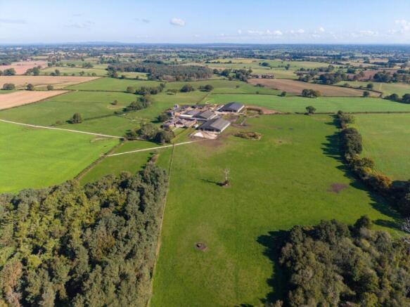
Whattall Farm is set around a steading at the centre of the holding. Bordered by woodland to the west and public roads to the north and east.
WHATTALL FARMHOUSE & YARD
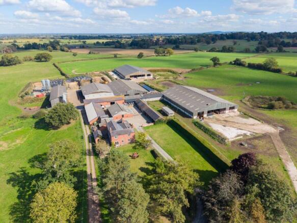
Set at the end of a long drive (which solely serves the farm and is council maintained for approximately two thirds of its length) the farmstead provides both a modern working base and family home.
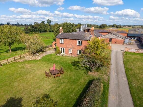
The farmhouse provides ample accommodation, with seven bedrooms. On the ground floor are two extensive reception rooms, alongside a family kitchen, utility, study, and ground floor bathroom, an additional bathroom to the first floor completes the property. The yard is set in two parts, with a traditional foldyard immediately adjoining the farmhouse (with a range of brick buildings, providing loose housing, a collecting yard and single-sided 20 point parlour alongside useful storage.) To the east and west of the foldyard sits the modern livestock accommodation and agricultural storage buildings, along with the slurry pits and earth-sided clamps. The farm is served by both mains and borehole supplies.
FARMLAND
The ground comprises predominantly Grade 3 soils, with a band of heavier Grade 4 land under the yard, woodland, and grazing land in the centre of the holding. The soils are described as a combination of light to medium sandy loams to the northern and southern parts, with deeper areas of peat in the central part of the farm. The farmstead and adjoining land is currently let on a Farm Business Tenancy to July 2026, with the other ground similarly let. Holdover and early entry is to be agreed between the parties. Parts of the farm are subject to a Countryside Stewardship agreement, which the buyer will be required to take over, further details of which are within the General Remarks or available from the selling agents. The mineral rights are not owned in respect of Lot 1, for further details please see the general remarks or contact the selling agents.
Situated just off the main A528 linking Ellesmere to Shrewsbury, the country around Whattall Farm is characterised by productive farmland, traditional villages, and a strong agricultural heritage. Gently rolling fields surround ‘Shropshire’s Lake District’, the locally noted meres being the most obvious evidence that remains of the effect the last ice age had on the area.
Brochures
Web DetailsLot 1 - Whattall Farm, Colemere, Ellesmere

NEAREST STATIONS
Distances are straight line measurements from the centre of the postcode- Wem Station5.1 miles
Notes
Disclaimer - Property reference NEF260015. The information displayed about this property comprises a property advertisement. Rightmove.co.uk makes no warranty as to the accuracy or completeness of the advertisement or any linked or associated information, and Rightmove has no control over the content. This property advertisement does not constitute property particulars. The information is provided and maintained by Strutt & Parker, National Estates & Farm Agency. Please contact the selling agent or developer directly to obtain any information which may be available under the terms of The Energy Performance of Buildings (Certificates and Inspections) (England and Wales) Regulations 2007 or the Home Report if in relation to a residential property in Scotland.
Map data ©OpenStreetMap contributors.