
Main Street, Swepstone
- PROPERTY TYPE
Land
- SIZE
Ask agent
Key features
- Well Maintained Woodland
- Edge of Village location
- In the heart of the National Forest
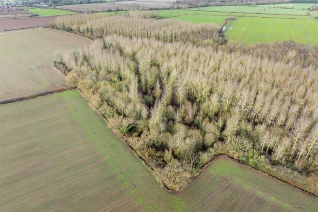
- A variety of Broadleaved species
Description
The woodland has mature hedgerow boundaries and is bordered by agricultural land on all sides.
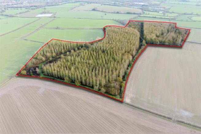
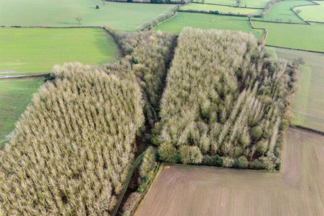
Description - The woodland is a large block extending to 28.08 acres of mature hardwood broadleaved trees, that includes an avenue of Poplar Trees. The woodland is divided by rides and pathways.
The woodland has mature hedgerow boundaries and is bordered by agricultural land on all sides.
Access is via a farm track off Church Street.
The woodland was planted in 2002 as part of a National Forest Woodland Planting Scheme, that has since expired.
Location - The woodland is situated to the south on the outskirts of the rural village of Swepstone.
The market towns of Ashby de la Zouch and Market Bosworth are within easy reach offering, retail shops, public houses, restaurants and leisure facilities.
The land benefits from good transport network links with A42 approximately 3 miles to the north.
Travel Distances
Measham 2.8 miles
Ashby de la Zouch 5.1 miles
Market Bosworth 6.2 miles
Coalville 6.4 miles
Woodland Grant Scheme - The woodland was established under the National Forest Tender Scheme in 2003. The agreement has reached the end of the annual payment period however as per the schemes requirements the land should remain under appropriate woodland management and felling licenses must be applied for the removal of trees.
Purchasers should be aware of the obligations under the agreement and be prepared to take on the management responsibility.
Permissive public access will remain on the land until June 2026
Services - Purchasers should make their own enquiries regarding the location of mains service supplies.
Title, Tenure & Possession - The property is sold Freehold with vacant possession upon completion.
Planning - The woodland sits within the confines of North West Leicestershire – .
Easements, Wayleaves & Rights Of Way - The land has a public footpath that cuts through the middle of the woodland and there are also several permissive tracks throughout.
The land is sold subject to and with the benefit of all other easements, wayleaves and rights of way that may exist at the time of the sale, whether disclosed or not.
Plan, Area & Description - The plan, area and description are believed to be correct in every way, but no claim will be entertained by the vendor or the agent in respect of any error, omissions or misdescriptions.
Please note the boundary outline as shown on the photos is for identification purposes only.
The photographs shown here in the brochure were taken in January 2026.
Viewing - Viewings are strictly by appointment only with Gabriella Bennion at Howkins & Harrison, please call direct on Tel:01530-877977 option 4
Anti Money Laundering - To enable us to comply with the Money Laundering Regulations we need to verify the buyer’s identity before proceeding with a sale.
We charge a small administration fee for conducting an electronic AML verification check via our online provider, MoveButler.
Brochures
Woodland to the South of Main Street.pdfBrochureMain Street, Swepstone

NEAREST STATIONS
Distances are straight line measurements from the centre of the postcode- Polesworth Station8.0 miles

Notes
Disclaimer - Property reference 34600707. The information displayed about this property comprises a property advertisement. Rightmove.co.uk makes no warranty as to the accuracy or completeness of the advertisement or any linked or associated information, and Rightmove has no control over the content. This property advertisement does not constitute property particulars. The information is provided and maintained by Howkins & Harrison, Ashby-De-La-Zouch. Please contact the selling agent or developer directly to obtain any information which may be available under the terms of The Energy Performance of Buildings (Certificates and Inspections) (England and Wales) Regulations 2007 or the Home Report if in relation to a residential property in Scotland.