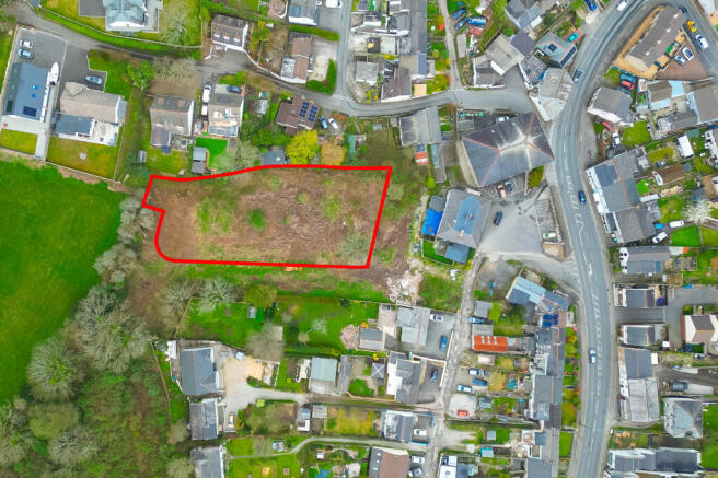
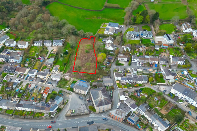
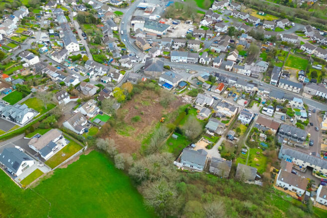
Fore Street, St. Blazey, Par, Cornwall, PL24 2NH
£5.56 per sq ft
Business rates & charges may apply
- SIZE AVAILABLE
56,628 sq ft
5,261 sq m
- SECTOR
Residential development for sale
Key features
- Full planning permission for the construction of 8 new build dwellings (PA22/10371)
- Cleared site
- OIRO £315,000
Description
Full planning permission was granted on 31st July 2023 for the land outlined in red on the front page of this brochure under planning reference: PA22/10371. This permission is for the construction of eight new dwellings (four pairs of semi-detached houses, six three-bedroom and two two-bedroom); provision of vehicular access road, vehicular parking, and external amenity garden space.
An application to discharge conditions 3,4,5,6,7,8,9,12 was submitted to Cornwall Council under planning reference: PA24/05632 on 18th July 2024. These conditions were later discharged on 22nd October 2024. The landowner has also now received confirmation of the discharge of condition 16 in relation to works to the Packhorse Inn next door.
In accordance with the CIL liability notice served in connection with the Planning Permission £83,622.59 is to be paid to the Council on commencement of development. Access to the development has been facilitated by the grant of access over the land owned by the Packhorse Inn to the left-hand side of the pub.
Location
The subject land lies within the village of St Blazey, part of the wider St Austell urban area. It is bordered by residential development, agricultural land and the A390, which runs through the centre of the village.
St Blazey has a population of approximately 5,000 residents. It is situated 3-miles east of St Austell town centre, 1-mile north of Par and 2.7-miles from the popular attraction known as the Eden Project.
Planning
Full planning permission was granted on 31st July 2023 for the land outlined in red on the front page of this report under planning reference: PA22/10371.
This permission is for the construction of eight new dwellings (four pairs of semi detached houses, six three-bedroom and two two-bedroom); provision of vehicular access road, vehicular parking, and external amenity garden space.
An application to discharge conditions 3,4,5,6,7,8,9,12 and 16 was submitted to Cornwall Council under planning reference: PA24/05632 on 18th July 2024. These conditions were later discharged on 22nd October 2024. The landowner has also now received confirmation of the discharge of condition 16 in relation to works to the Packhorse Inn next door.
In accordance with the CIL liability notice served in connection with the Planning
Permission £83,622.59 is to be paid to the Council on commencement of development.
A right of access to the development has been granted over the land owned by the Packhorse Inn to the left-hand side of the pub.
Rent / Price
OIRO £300,000
Services
We understand that mains electricity, water and drainage are connected to the property however these services have not been tested by the agents. Interested parties should make their own enquiries.
Legal Fees
Each party to be responsible for their own legal fees in relation to this transaction.
VAT
All figures quoted are exclusive of VAT if applicable.
Brochures
Fore Street, St. Blazey, Par, Cornwall, PL24 2NH

NEAREST STATIONS
Distances are straight line measurements from the centre of the postcode- Par Station0.8 miles
- Luxulyan Station2.3 miles
- St. Austell Station3.6 miles
Notes
Disclaimer - Property reference 21739FH. The information displayed about this property comprises a property advertisement. Rightmove.co.uk makes no warranty as to the accuracy or completeness of the advertisement or any linked or associated information, and Rightmove has no control over the content. This property advertisement does not constitute property particulars. The information is provided and maintained by Vickery Holman, Truro. Please contact the selling agent or developer directly to obtain any information which may be available under the terms of The Energy Performance of Buildings (Certificates and Inspections) (England and Wales) Regulations 2007 or the Home Report if in relation to a residential property in Scotland.
Map data ©OpenStreetMap contributors.