Land At Keysoe, Bedfordshire
- PROPERTY TYPE
Land
- SIZE
3,374,593 sq ft
313,510 sq m
Key features
- Grade 2 & 3 agricultural land
- Available as a whole or two lots
- Vacant possession on completion
Description
Situation
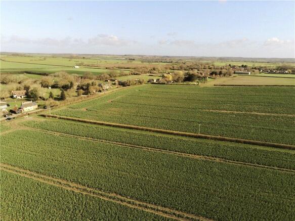
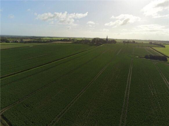
Located on the outskirts of the village of Keysoe and surrounded by neighbouring agricultural land, we are pleased to offer the opportunity to purchase 77.47 acres (31.35 hectares) of productive arable land, offered in good heart and available in two lots. Lot 1 is found within 2 miles of the well-served village of Riseley and 5 miles of the historic market town of Kimbolton. Central Bedford can be accessed within 9 miles. Lot 2 is found just south-east of Lot 1 but is equally well accessible to local towns and villages. Keysoe Row is on the doorstep. The lots are within close proximity to one another, making them desirable either as a combined purchase for one buyer or as separate opportunities for individual buyers.
Lot 1 - 60.37 acres (24.43 hectares)
Three contiguous parcels of Grade 2/3 agricultural land accessible from Riseley Road. Situated south-east of Riseley Road, the land comprises three regularly shaped parcels with long road frontage and good access. The land is in good-sized fields, well suited to modern arable farming. Boundaries for the most part are made up of well-maintained hedges. The land is partly under-drained. The soil is of the Denchworth series; slowly permeable seasonally waterlogged clayey soil. The land in recent years has been in combinable arable crop rotation. The parcels are currently in a crop of oilseed . A small area of one field is currently in a Countryside Stewardship Scheme, under the SW3 (in-field grass strip) option. There is a public footpath running along a boundary in the southern parcel. A plan showing the location is available in the dataroom. A cropping schedule is available in the particulars attached.
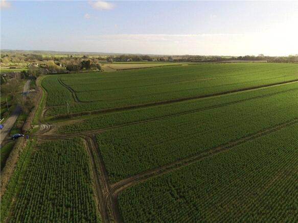
Lot 2 - 17.10 acres (6.92 hectares)
A single parcel of Grade 2/3 agricultural land accessible from Kimbolton Road. This parcel of gently sloping land is located east of Kimbolton Road (B660) with direct gated access from the road. The field is of a good workable shape. Boundaries to the fields are generally well defined on the ground and are largely made up of mature hedging and trees. The soil is of the Hanslope Series; slowly permeable calcerous clayey soil. The land in recent years has been in combinable arable crop rotation. The land is currently in a crop of winter wheat. The land is not currently entered into any environmental schemes. There are no known public rights of way across Lot 2. A cropping schedule is available in the particulars attached.
Tenure & Possession
The land is offered for sale with vacant possession on completion.
Drainage Rates
Environment Agency drainage rates are currently payable at the standard rates.
VAT
The land is not registered for VAT, however if the sale of the property or any right attached to it is deemed a chargeable supply for the purpose of VAT, such tax shall be payable by the purchaser in addition to the sale price.
Method of Sale
The land is offered for sale by private treaty as a whole or in up to two lots, with vacant possession upon completion.
Farming Arrangements
It is anticipated that the seller will complete the 2026 harvest and will be subject to the holdover arrangements below. The seller would be willing to engage in a Contract Farming Agreement over both lots with the buyer(s) should this be required.
Environmental Schemes
An area of one parcel in Lot 1 is subject to a Mid Tier option under the Countryside Stewardship Scheme. This is due to expire in 2027. The seller will transfer this grant to the buyer upon completion. More information can be found in the dataroom.
Services
There are no known services attached to either Lot 1 or Lot 2.
Soil Information
SOYL Reports and Organic Matter Reports are available for Lot 1 and 2 in the dataroom.
Titles
All titles are included in the dataroom, and the boundaries are generally well defined on the ground.
Basic Payment Scheme
The land has been claimed for BPS entitlements and is registered on the Rural Land Register. The seller will retain any historic delinked payments.
Timber, Minerals & Sporting
The timber and mineral rights are included within the title insofar as they are present.
Wayleaves, Easements & Rights of Way
The property is offered subject to all rights of way, wayleaves and easements whether or not disclosed. In particular, Lot 1 is subject to a public footpath and overhead lines. See the dataroom for further information.
Designations
The land is within a Nitrate Vulnerable Zone. We are unaware of any other designations, though prospective buyers should undertake their own investigations.
Local Authority
Bedford Borough Council, 138 Cauldwell Street, Bedford MK42 9AP
Holdover
The seller may reserve holdover rights for farming or occupation, subject to the date of completion. Buyers should make agents aware of any early entry requirements.
Ingoing Valuation & Dilapidations
An appropriate valuation clause will be included within the sale agreement to cover the payment for growing crops, dependent on the date of completion of sale. There will be no payment for Unexhausted Manurial Values and Residual Manurial Values. There will be no claim for dilapidations.
Health & Safety
Given the potential hazards of a working farm, good care should be taken when inspecting the sites. Viewings are permitted unaccompanied in daylight hours with a set of particulars in hand.
Anti-Money Laundering
Buyers will be required to provide proof of identity and address to the selling agent following acceptance of an offer (subject to contract) and prior to solicitors being instructed.
Plans, Areas & Schedules
Plans attached to the particulars are based upon Ordnance Survey data and are for identification purposes only.
Seller's Solicitor
Charlotte Benjamin Woodfines, Brickstone House, Stannard Way, Priory Business Park, Bedford MK44 3WG
Nearest Postcodes
Lot 1: MK44 2HT Lot 2: MK44 2HH
what3words Location
The what3words location for access: Lot 1: intruded.unrealistic.suppers Lot 2: silently.begins.swarm
Contact
To arrange a viewing and for access to the dataroom, please contact Andrew Capel or Emma Ilsley.
Brochures
ParticularsLand At Keysoe, Bedfordshire

NEAREST STATIONS
Distances are straight line measurements from the centre of the postcode- St. Neots Station7.9 miles
About Robinson & Hall LLP, Bedford
Unit 1, Highfield Court Highfield Road Oakley Bedford MK43 7TA


Notes
Disclaimer - Property reference BED260003. The information displayed about this property comprises a property advertisement. Rightmove.co.uk makes no warranty as to the accuracy or completeness of the advertisement or any linked or associated information, and Rightmove has no control over the content. This property advertisement does not constitute property particulars. The information is provided and maintained by Robinson & Hall LLP, Bedford. Please contact the selling agent or developer directly to obtain any information which may be available under the terms of The Energy Performance of Buildings (Certificates and Inspections) (England and Wales) Regulations 2007 or the Home Report if in relation to a residential property in Scotland.