Low Harperley Farm, Wolsingham
Business rates & charges may apply
- SIZE
Ask agent
- SECTOR
Farm for sale
Key features
- Opportunity to acquire a substantial turn key, staffed, organic farming operation with livestock and relevant equipment available.
- Five bedroom, four bathroom Grade II* Listed Farmhouse.
- Grade II Listed stone built barn.
- Certified organic grassland, arable and livestock farm.
- Extensive range of modern and traditional farm buildings.
- Rural yet accessible location.
Description
The property extends to 159.98 hectares (395.31 acres) in total and is located in a peaceful, rural
setting, at the gateway to Weardale, to the east of Wolsingham in County Durham.
LOCATION
Low Harperley Farm is situated in a rural yet accessible location in County Durham. It is approximately 3 miles to the east of the small market town of Wolsingham and 4 miles to the west of the larger town of Crook. The city of Durham is approximately 14 miles to the north east which provides a wider range of shopping and recreational facilities.
There are several primary and secondary schools in the surrounding area.
For the commuter the A68 is less than a 5 minute drive away and provides access to main road networks including the A1(M). Train stations can be found at Bishop Auckland and Durham, which is situated on the east coast main line. There are international airports at Teeside and Newcastle.
What3words: ///albums.slippers.forces
ACCESS
A tarmac and metaled road leads to the farmhouse and steading from the A689.
Field parcels 8851, 4337, 0431, 9357 and 7735 have roadside frontage to the A689.
There is also a right of access from the A68 which leads through the College of Policing to the southern field parcels.
All access points are identified on the Sale Plan.
There are several tracks around the farm from the steading providing access to all fields.
DESCRIPTION
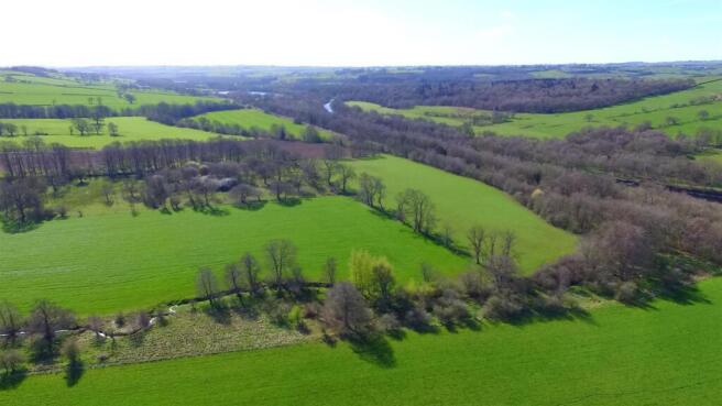
Low Harperley Farm is a well equipped livestock, grassland and arable farm lying within a ring fence extending to 159.98 hectares (395.31 acres) in total. This includes 80.52 hectares (198.96 acres) arable, 62.02 hectares (153.26 acres) grassland and 14.51 hectares (35.84 acres) woodland.
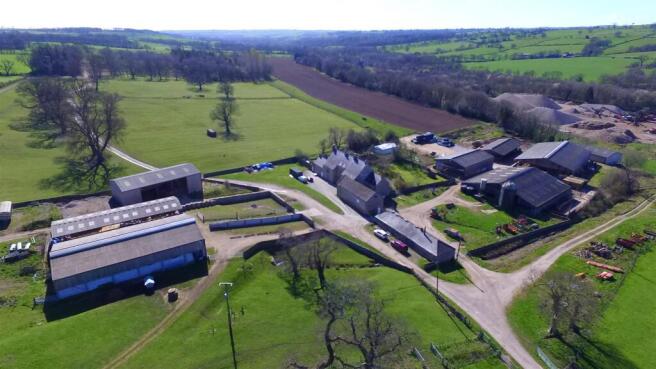
The farmhouse and buildings are centrally located and the steading provides access to all land parcels from internal access tracks. There are ample modern buildings which are well established for cattle and sheep rearing.
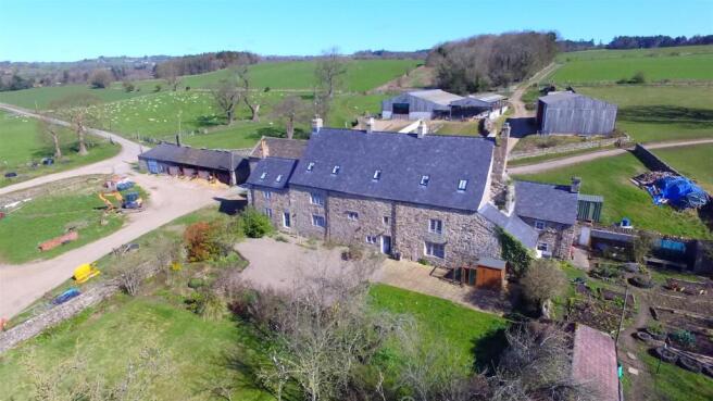
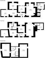
THE FARMHOUSE
Dating back to the late 1200’s and continuously remodeled since, the farmhouse is a striking and expansive five bedroom, three story, stone built Grade II* Listed house under slate roof. It has recently been substantially and sympathetically renovated to a very high standard. Whilst retaining its character and embracing the traditional features, it has been well insulated, re roofed and modernised.
The layout of the accommodation is shown on the floorplan, the ground floor comprises a large kitchen diner with Aga, utility room, games room, music room, lounge and office, to the first floor there are three bedrooms, all with large en suite bathrooms and the second floor has two further bedrooms and a bathroom.
There is a redundant Grade II Listed cottage (Building 8 on the Buildings Plan) located in field parcel 7104.
THE BUILDINGS
To the west of the farmhouse is a two story stone built Listed building (Building 2) which is currently used as a welfare room and store but could be suitable for an alternative use subject to obtaining the necessary consents. Adjacent to this is a single story stone built building currently housing the bull pens and woodchip boiler. Again, this could be suitable for an alternative use. The remaining buildings are predominately modern portal framed with the sheep housing and handling buildings to the north of the farmhouse and cattle housing to the south. Building 15 is located to the south of field parcel 5958, adjacent to the College of Policing.
THE LAND
The land includes 80.52 hectares (198.96 acres) arable, 62.02 hectares (153.26 acres) grassland and 14.51 hectares (35.84 acres) woodland and is within a ring fence around the steading.
The land is fully certified organic and is in good heart. Gently sloping towards the River Wear, it is south facing and comprises productive arable and grassland which in the main is currently down to temporary grass to suit the livestock enterprises.
The boundaries are stock proof and comprise post and wire fencing, hedges and mains electric fencing which have had significant improvement in 2026 through Countryside Stewardship Capital Grants.
The majority of the land parcels are served by mains and spring water.
In accordance with the provisional land classification, the land is classified as Grade 3 and the soil is described as freely draining acid, sandy and loamy soils and slowly permeable seasonally wet acid, loamy and clayey soils.
Low Harperley Gravel Pit, currently operated by Breedon Group is situated on the western boundary of the farm. The land was historically part of Low Harperley Farm and the property benefits from an option to buy back this area following restoration and an aftercare period. This includes lakes, woodlands and open space, with the restoration plan being available from the selling agent upon request. Based on current workings this is envisaged to be in 2037.
There is land lying to the west of Weardale railway line and east of the River Wear which is included, as shown on the Sale Plan. There are rights of access to this land over the land owned by Low Harperley Quarry.
ENVIRONMENTAL / COUNTRYSIDE STEWARDSHIP
The land is registered with the Rural Payments Agency and the de linked Basic Payment has been claimed.
The land is subject to two SFI agreements which cannot be transferred to the purchaser. Further details of the options included in the agreements can be provided by the selling agent, if required.
LIVESTOCK
There are 110 Pedigree Salers and followers certified organic breeding female cattle which are performance recorded, certified Johne’s Disease Risk Level 1 and BVD free, and an organic MV accredited sheep flock consisting of 350 head of predominately Lleyn ewes and followers. There are also 90 organic hens with mobile hen house along with a range of modern agricultural machinery which can be included in the sale by separate negotiation.
The vendors retain the right to hold an on farm dispersal sale following completion.
FARM WORKERS
There are currently two highly competent full time farm workers who are integral to the farming operations at Low Harperley Farm and any purchaser is required to continue employing them through the TUPE (Transfer of Undertakings, Protection of Employment Regulations 2006). Further details on this can be provided subject to signing a Non Disclosure Agreement.
SERVICES
The property is served by mains electricity, mains water, septic tank drainage and a woodchip boiler, which is located in Building 1 (on the Building Plan) providing the heating and hot water to the farmhouse and adjoining barn (Building 2).
COUNCIL TAX BAND
Low Harperley Farm—Durham County Council Tax Band TBC
Low Harperley Farm Workers Cottage (Listed Cottage)—Durham County Council Tax Band A.
ENERGY PERFORMANCE CERTIFICATE
The property is Listed and therefore does not have an EPC.
PUBLIC RIGHTS OF WAY
The property is subject to public footpaths and bridleways. The current routes are identified on the Sale Plan, however these are subject to imminent changes which includes re routing the bridleway away from the farmhouse and farmyard and an extension of the bridleway network along part of the farm access road and through field 5145. Further details can be obtained from the selling agent.
THIRD PARTY RIGHTS OF WAY
There is a third party right of access for one person to park and fish the River Wear. Weardale Railway also have a right of access to access their railway line.
DESIGNATIONS
The property does not fall within any specific designations.
SPORTING / MINERAL / FISHING RIGHTS
The Sporting, mineral and fishing rights are owned and in hand.
There are approximately 1 mile of fishing rights which are identified on the Sale Plan.
In respect of the shooting rights, there is an active shoot under an informal lease arrangement which can be terminated by the purchaser if they wish following the 2027/2028 shooting season.
WAYLEAVES / EASEMENTS
There is a wayleave in place for the electricity lines which cross the property.
There is a gas pipeline crossing the property, for which a profit à prendre agreement is in place.
The property is sold subject to and with the benefit of all rights including rights of way, whether public or private, light, support, drainage, water and electricity supplies and other rights and obligations, easements and quasi-easements and restrictive covenants and all existing and proposed wayleaves for masts, pylons, stays, cables, drains, water and gas and other pipes whether referred to in these particulars or not.
MATERIAL INFORMATION
It is understood that the property has access to a good broadband connection and has good mobile phone signal in this area. We would advise prospective purchasers to perform their own due diligence in respect of availability. With reference to data from the Environment Agency’s Flood Warning Information Service there is a low risk of flooding from surface water, rivers and sea adjacent to the ditches around the farm.
COSTS
Each party is to bear their own costs.
MONEY LAUNDERING
Prospective buyers should be aware that in the event that they are successful they will be required to provide documents in relation to the current Money Laundering and Terrorist Financing Regulations. The extent of the required documentation will be confirmed to the purchaser(s) after acceptance of an offer.
TENURE
We are informed by the current vendors that the property is held freehold.
METHOD OF SALE
The property is offered for sale as a whole by private treaty.
VIEWINGS
Please contact Vickers & Barrass Tow Law office on to arrange a viewing, which are strictly by appointment only.
LOCAL AUTHORITY
Durham County Council.
HEALTH & SAFETY
The farm is an active and working farm and those viewing are requested to be mindful of farming operations. There is also no access to the redundant farm cottage due to its condition.
RELATED PARTY CONFLICT
This property is marketed on behalf of a “connected person” as defined in section 32(1) of the Estate Agent Act 1979.
NOTES
Particulars prepared – April 2026
Photographs taken – April 2026
BUYERS PACK (subject to NDA)
Farm Worker Information
Livestock and Machinery Schedules
SFI Agreements
Gravel Pit Restoration Plan
Public Rights of Way Information
Other relevant information
PARTICULAR NOTES
The particulars are set out as a general outline for the guidance of intending purchasers or lessees and do not constitute, all or part of an offer or contract; all descriptions, dimensions, areas, references to condition and necessary consents for use and occupation and other details are given as a guide only and without responsibility. Any intending purchasers or lessees should not rely on them as statements or representations of fact but must satisfy themselves, by inspection or otherwise, as to their accuracy.
No employee of Vickers & Barrass, Chartered Surveyors has the authority to make or give any representation or warranty whatever in relation to this property nor is any such representation or warranty given by the Vendors or the Lessors of this property.
Any offer for this property will be taken as an admission by the intending purchaser that they have relied solely upon their own personally verified information, inspection, and enquiries.
The photographs show only certain parts of the property. It should not be assumed that the property remains as displayed in the photographs.
Where any reference is made to planning permissions or potential uses, such information is given by Vickers & Barrass, Chartered Surveyors in good faith. Prospective purchasers should make their own enquiries with the Local Planning authority into such matters.
The Vendors reserve the right to amalgamate, withdraw or exclude either of the lots shown at any time and to generally amend the particulars or method of sale.
The property is sold subject to reserve(s). Vickers & Barrass, Chartered Surveyors reserve the right to sell privately without imposing a closing date and do not bind themselves to accept the highest or any offer. The particulars have been prepared in accordance with the Business Protection from Misleading Marketing Regulations to give a fair overall view of the property.
Brochures
Low Harperley Farm, Wolsingham

NEAREST STATIONS
Distances are straight line measurements from the centre of the postcode- Bishop Auckland Station7.0 miles
About Vickers and Barrass, Darlington
16/17 Castle Bank Tow Law Bishop Auckland County Durham DL13 4AENotes
Disclaimer - Property reference 34624112. The information displayed about this property comprises a property advertisement. Rightmove.co.uk makes no warranty as to the accuracy or completeness of the advertisement or any linked or associated information, and Rightmove has no control over the content. This property advertisement does not constitute property particulars. The information is provided and maintained by Vickers and Barrass, Darlington. Please contact the selling agent or developer directly to obtain any information which may be available under the terms of The Energy Performance of Buildings (Certificates and Inspections) (England and Wales) Regulations 2007 or the Home Report if in relation to a residential property in Scotland.