
LL13
- PROPERTY TYPE
Farm Land
- SIZE
87,556 sq ft
8,134 sq m
Key features
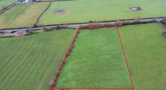
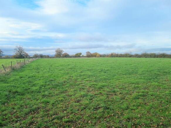
- 2.01 acres (0.81 Ha) of pastureland
- Suitable for an agricultural, equestrian or amenity use (subject to planning)
- Good access
- Idyllic location
Description
2.01 acres (0.81 Ha) of pastureland, suitable for an agricultural, equestrian or amenity use (subject to planning). The land benefits from excellent access from the main road and an idyllic rural location.
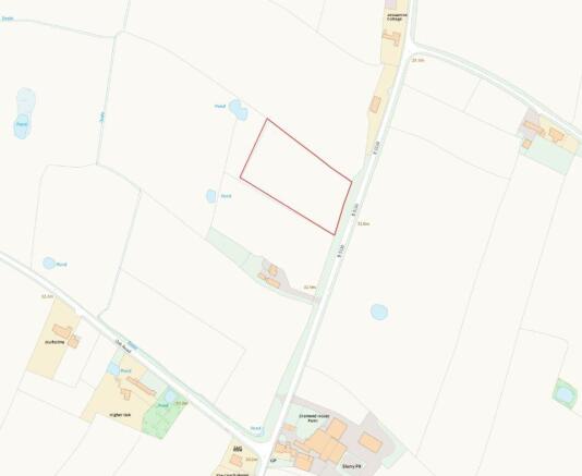
DIRECTIONS
Heading west on the A534 (Wrexham Road), turn left onto the B5130. Follow the road for approximately 8 miles where the land will be located on your right, indicated by a sale board.
What3Words - ///suits.limit.picture
VIEWINGS
The land can be viewed at any reasonable time without prior appointment with the selling agent. We request that you take a copy of these sales details with you when viewing the land.
BASIC PAYMENT SCHEME (BPS)
The land is not registered with Rural Payments Wales and no entitlements will be included with the land sale.
TENURE & TITLE
Freehold registered title under CYM289202 with vacant possession upon completion.
OVERAGE
The land will be sold subject to an overage provision where the
vendor will be entitled to 50% of the uplift in value resulting in
any use other than agricultural or equestrian. This will be in
place for 25 years. This will be triggered upon the grant of
planning or if any change of use is implemented.
SERVICES
None.
SOIL TYPE LAND GRADE
According to the Cranfield Soil and Agri-food Institute
(Soilscapes of England & Wales), the soil is classed as "Soilscape
18" described as slowly permeable seasonally wet slightly acid
but base-rich loamy and clayey soils. The land is Grade 3 (Land
Classification Series for England & Wales) (Grade 1 - best,
Grade 5 - worst).
FENCING
The purchaser is responsible for erecting and maintaining their
own stockproof boundary fences.
ACCESS
The land can be accessed from the B5130 through a gated
entrance.
TOWN AND COUNTRY PLANNING ACT
The property not withstanding any description contained in
these particulars, is sold subject to any development plan, tree
preservation order, town planning scheme or agreement,
resolution or notice.
SALE PLAN AND PARTICULARS
The sale plan is based on the Ordnance Survey sheet.
Prospective purchasers should check the contract documents.
The purchasers shall raise no objection or query in respect of
any variation between the physical boundaries and the
Ordnance Survey sheet plan. The plans are strictly for
identification purposes only.
MONEY LAUNDERING LEGISLATION
Rostons Ltd must comply with Anti Money Laundering
legislation. As part of the requirements, Rostons must obtain
evidence of the identity & proof of address of potential buyers.
Prior to an offer being accepted, all parties who are purchasing
must provide the evidence.
EASEMENTS, WAYLEAVES AND RIGHTS OF WAY
The land is sold subject to and with the benefit of all public
and private rights of way, lights, drainage, cable, pylons or
other easements, restrictions or obligations whether or not
the same are described in these particulars of sale. The land
benefits from a right of way, please refer to the accompanying
Title Plan.
SITUATION
The land is located 10 miles east of Wrexham and 13 miles
south of Chester.
Brochures
Brochure 1Brochure 2
NEAREST STATIONS
Distances are straight line measurements from the centre of the postcode- Wrexham Central Station4.3 miles
- Wrexham General Station4.5 miles

About Rostons, Hatton Heath
West View House Whitchurch Road, Hatton Heath, CH3 9AU
Notes
Disclaimer - Property reference CP10700. The information displayed about this property comprises a property advertisement. Rightmove.co.uk makes no warranty as to the accuracy or completeness of the advertisement or any linked or associated information, and Rightmove has no control over the content. This property advertisement does not constitute property particulars. The information is provided and maintained by Rostons, Hatton Heath. Please contact the selling agent or developer directly to obtain any information which may be available under the terms of The Energy Performance of Buildings (Certificates and Inspections) (England and Wales) Regulations 2007 or the Home Report if in relation to a residential property in Scotland.
Map data ©OpenStreetMap contributors.