

Land at Castle Donnington
- PROPERTY TYPE
Land
- SIZE
Ask agent
Description
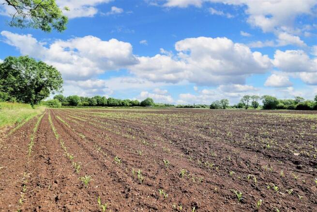
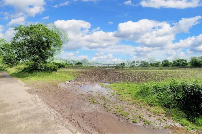
Description - Approximately 19.08 acres of level arable land, currently planted with spring maize, bounded by a mixture of mature hedges and hedgerow trees. The land has roadside access and frontage along the gated road Back Lane, Castle Donington.
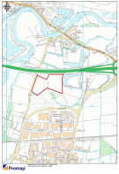
Location - The land lies directly north of the village of Castle Donington, which is situated to the southwest of the city of Derby. While the land adjoins the A50, access is provided via the gated Back Lane.
What3Words: ///applied.manifests.chess
Guide Price - The land is marketed at a guide price of £160,000.
Method Of Sale - The land is offered for sale by Private Treaty and is currently subject to a Farm Business Tenancy. Vacant possession will be available from September 2025.
Land Classification And Soil Type - The land is classed as Grade 2 agricultural land.
Soilscapes defines the soil as freely draining floodplain soils (Soilscape 12).
The North West and North East corners are classed as freely draining slightly acidic loamy soils (Soilscape 6).
Services - The agent is not aware that the land benefits from any mains service connections.
Tenure - The land is to be sold freehold, with vacant possession available upon expiry of the current Farm Business Tenancy in September 2025. The tenant holds the rights to holdover to remove the standing crop.
Environmental Schemes - The agent is not aware that the land is subject to any environmental schemes.
Wayleaves, Easements And Rights Of Way - The land has a footpath (L86) that runs across the centre of the east parcel of the land that runs from a north to the southeast direction.
The land is sold subject to all wayleaves, easements and rights of way that may exist whether specifically mentioned in these particulars or not.
Sporting, Timber And Mineral Rights - All sporting, timber and mineral rights, where owned, are included in the sale.
Flood Zone - The land is located within Flood Zone 3.
Rates And Other Outgoings - The property is sold subject to any other rates and outgoings which the Purchaser will be liable for.
Development Uplift Clause - The property will be sold subject to an uplift clause whereby 30% of any increase in value arising from development or the grant of planning permission (excluding uses for agriculture and equestrian purposes) and will be payable to the vendor for a period of 30 years from the date of completion.
Vat - In the event that any part of the holding is subject to VAT this will be payable by the Purchaser in addition to the purchase price.
Viewings - Viewing of the land may take place at any time during daylight hours by persons in possession of a copy of these particulars.
Land Registry - The land for sale is comprised of two adjoining titles, detailed as follows:
Title Number LT512825 – approximately 17.6 acres
Title Number LT431207 – approximately 1.48 acres
Plan - The plan and red lines are based on Ordnance Survey data and provided for reference purposes only. The vendor not the Vendor's agent are responsible for defining the boundaries or the ownership.
Further Information - For any further information, please contact:
Eloise Baker MSc BSc
Andrew Granger & Company
44-46 Forest Road, Loughborough, LE11 3NP
Tel:
E-mail: eloise.
Brochures
Land at Castle DonningtonLand at Castle Donnington

NEAREST STATIONS
Distances are straight line measurements from the centre of the postcode- Long Eaton Station3.2 miles
- East Midlands Parkway Station3.4 miles
- Spondon Station4.8 miles

Notes
Disclaimer - Property reference 33950846. The information displayed about this property comprises a property advertisement. Rightmove.co.uk makes no warranty as to the accuracy or completeness of the advertisement or any linked or associated information, and Rightmove has no control over the content. This property advertisement does not constitute property particulars. The information is provided and maintained by Andrew Granger, Loughborough. Please contact the selling agent or developer directly to obtain any information which may be available under the terms of The Energy Performance of Buildings (Certificates and Inspections) (England and Wales) Regulations 2007 or the Home Report if in relation to a residential property in Scotland.
Map data ©OpenStreetMap contributors.