
Established smallholding in Charlwood, Surrey, RH6 0ES
£1.03 per sq ft
Business rates & charges may apply
- SIZE AVAILABLE
339,332 sq ft
31,525 sq m
- SECTOR
Smallholding for sale
Key features
- Substantial smallholding.
- Range of agricultural buildings.
- Highly sought-after area.
- 7.79 acres of flat pasture land.
- Enclosed by a stock-proof fencing and mature woodland.
- Providing privacy and tranquillity.
- 165ft borehole, providing water for livestock.
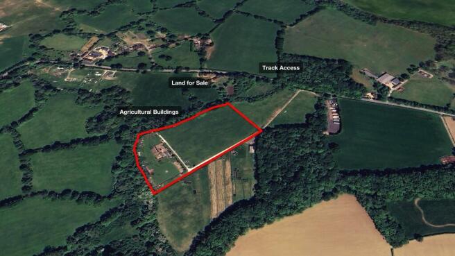
- Accessed via a well-made, hard surface track.
- Affluent location, close to excellent transport links.
- Download the brochure & site plan using the link below.
Description
This is a wonderful opportunity for you to own a good-sized block of land with a range of agricultural buildings in a highly sought-after area.
Totalling 7.79 acres, this flat pasture land is enclosed by a mixture of stock-proof fencing and mature woodland, providing privacy and tranquillity.
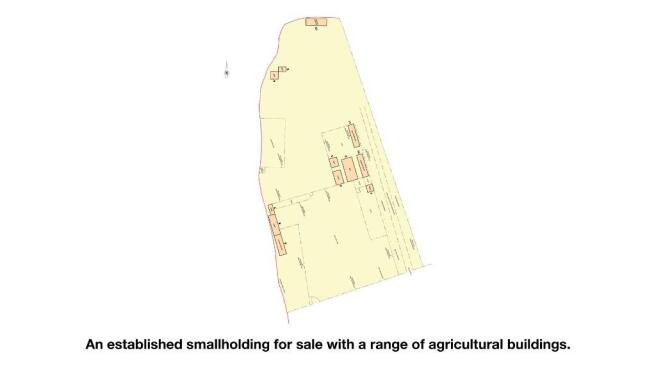
The western section of the site is already established as a substantial smallholding with a range of agricultural buildings, including a sizeable welfare unit (details on the next page).
Additionally, the site benefits from a 165ft borehole, providing water for livestock. Access to the land is via a well-made, hard surface track from a double-gated entrance that is set-back from Stan Hill Road.
The land is pleasantly situated between the affluent and vibrant villages of Charlwood and Newdigate, which provide everyday amenities. While the land enjoys a semi-rural feel, it also boasts excellent nearby transport connections, making it easy to reach larger towns and a wider range of facilities.
PLANNING
It is understood that the land has planning permission for the following:
- A large welfare unit with kitchen, lounge, bathroom & bedroom (serviced by solar power & propane gas)
- 2 x sheds
- 6 x stables
- 4 x aviaries for poultry
- 3 x pig arks
- 36ft polytunnel
- A large field shelter
These were granted under the appeal application APP/C3620/C/17/3169646 and the planning application MO/2018/1650.
The land is situated within the Metropolitan Green Belt. Any further development or change of use would be subject to the appropriate permission.
LOCAL AUTHORITY
Mole Valley District Council
ACCESS
The land is accessed via a secure, double-gated entrance that is set-back from Stan Hill road. Full vehicular access to the land is via a well-made, hard-surface track.
WHAT3WORDS
The approximate location of the double-gated entrance on Stan Hill can be found here - ///post.jumpy.belt
The approximate location of the land can be found here - ///copy.status.menu
LAND VALUES
Pasture land prices in the region are 14% higher than the average as land values rose again last year, despite numerous challenges in the local market & global economy.
This once again shows the inherent resilience of agricultural land as a tangible asset.
With a wide range of potential uses, agricultural land remains an attractive investment for a diverse range of buyers. This is supported by the fact that, in the past 5 years, land values have risen by 31%, outperforming the FTSE 100, UK property prices and interest from savings in the bank.
These rises are driven by historically low levels of land availability, as demand continues to outstrip supply.
PROPERTY PRICES
The land is situated within an extremely affluent area. Property prices in Charlwood are 16% above the already high Surrey average and 95% above the national average. These premium house prices reflect the desirability of the area as a place to live and own property - including land.
LOCATION
- Between Charlwood & Newdigate
- 3.5 miles to Horley
- 4.8 miles to Reigate
- 5.2 miles to Dorking
- 5.4 miles to Crawley
- 5.7 miles to Redhill
- 8.4 miles to Horsham
- 23.1 miles to Central London
The land is pleasantly situated between the charming and highly sought-after villages of Charlwood and Newdigate. The area boasts a vibrant community and offers an excellent range of amenities for day-to-day needs, including local shops, a post office, pubs & eateries.
For more extensive shopping and leisure options, the larger towns of Horley, Reigate, Dorking and Crawley are all within easy reach. They each offer a range of high street and boutique shops, plus a selection of bustling cafés, bars and restaurants.
While the land enjoys a setting within beautiful countryside, it is also conveniently close to Gatwick Airport and key road links, making the area ideal for those wishing to commute for work or leisure.
The A24 to the west and the M23 to the east, provide easy access to the south coast, the M25 and the wider motorway network as well as Central London. Additionally, a choice of mainline railway stations at nearby Holmwood & Gatwick offer frequent and direct links to London in half an hour.
TRANSPORT LINKS
- 2.7 miles to the A24
- 3.4 miles to London Gatwick Airport
- 4.2 miles to Gatwick Airport Train Station **
- 5.3 miles to the M23 (J9)
- 8.2 miles to the M25 (J7)
* Journey Times: 26 mins to Brighton; 29 mins to London Bridge; 31 mins to London Victoria; 44 mins to London St Pancras International
METHOD OF SALE
The land is offered for sale by private treaty. The freehold is available with vacant possession on completion.
VIEWING
Please contact Vantage Land for viewing instructions.
Brochures
Established smallholding in Charlwood, Surrey, RH6 0ES

NEAREST STATIONS
Distances are straight line measurements from the centre of the postcode- Holmwood Station2.9 miles
- Horley Station4.1 miles
- Gatwick Airport Station4.2 miles
Notes
Disclaimer - Property reference Charlwood779. The information displayed about this property comprises a property advertisement. Rightmove.co.uk makes no warranty as to the accuracy or completeness of the advertisement or any linked or associated information, and Rightmove has no control over the content. This property advertisement does not constitute property particulars. The information is provided and maintained by Vantage Land & Property, Harpenden. Please contact the selling agent or developer directly to obtain any information which may be available under the terms of The Energy Performance of Buildings (Certificates and Inspections) (England and Wales) Regulations 2007 or the Home Report if in relation to a residential property in Scotland.
Map data ©OpenStreetMap contributors.