Land at Halton Lea Gate, Northumberland
- PROPERTY TYPE
Land
- SIZE
3,472,603 sq ft
322,616 sq m
Key features
- 32.26 hectares (79.72 acres) Permanent grassland
- Roadside access
- Available as a whole
- Suitable for natural capital projects subject to obtaining the necessary consents
Description
LOCATION
The land is located to the north of Halton-Lea-Gate in Northumberland. It is positioned approximately 7 miles to the south of Haltwhistle, 10 miles to the east of Brampton and 10 miles to the north of Alston.
What3words — dimension.fatigued.towns
ACCESS
The land is accessed from the single track road which leads north from the A689 (running from Lambley to Halton-Lea-Gate), this is marked ‘A’ on the Sale Plan. This leads into field NY6559 4938 and the parcels are accessed internally thereafter. NY6459 9044 is to the west of Hartly Burn and therefore the burn must be crossed to reach the field.
DESCRIPTION
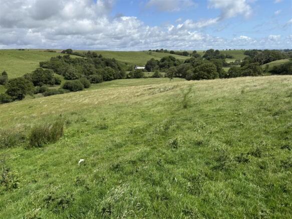
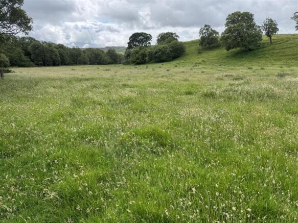
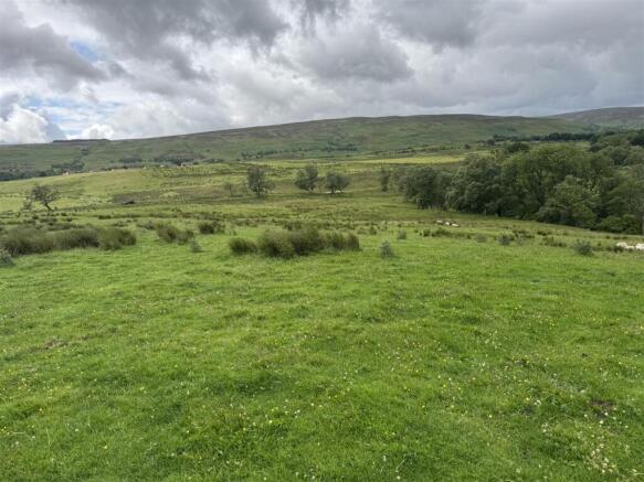
An opportunity to purchase a block of permanent grassland extending to 32.26 hectares (79.72 acres) in total.
The land comprises of five parcels of permanent grassland, mainly used for grazing which are divided by Hartley Burn. Two thirds of the land falls within parcel 9044, to the west of the burn. This parcel is productive but is steep in places and can only be accessed by crossing Hartley Burn. The land to the east of the burn includes four smaller parcels which are used for grazing, the topography is gently rolling with a slope down to the watercourse.
The land may be suitable for a variety of alternative purposes such as regenerative agriculture, rewilding projects, natural capital benefits or biodiversity net gain subject to obtaining the necessary consents.
The boundaries are stock proof comprising post and wire fencing. The land does not have a mains water supply.
The land is classified as Grade 4 and is described as slowly permeable seasonally wet acid loamy and clayey soil.
ENVIRONMENTAL LAND MANAGEMENT SCHEMES
The land is subject to a Mid Tier Countryside Stewardship scheme which ends on 31st December 2027. Further details of the agreement can be obtained from the selling agent's.
DESIGNATIONS & PUBLIC RIGHTS OF WAY
The land is subject to public footpaths which cross all of the parcels, the routes are shown on the Sale Plan by a dashed orange line.
The land falls within the Disadvantaged Less Favoured Area.
EASEMENTS AND OUTGOINGS
The property is sold subject to and with the benefit of all rights including rights of way, whether public or private, light, support, drainage, water and electricity supplies and other rights and obligations, easements and quasi-easements and restrictive covenants and all existing and proposed wayleaves for masts, pylons, stays, cables, drains, water and gas and other pipes whether referred to in these particulars or not.
SPORTING AND MINERAL RIGHTS
The mines and mineral rights and the sporting rights are excluded.
MATERIAL INFORMATION
With reference to data from the Environment Agency’s Flood Warning Information Service there is a medium risk of flooding immediately surrounding Hartley Burn.
COSTS
Each party is to bear their own costs.
MONEY LAUNDERING
Prospective buyers should be aware that in the event that they are successful they will be required to provide documents in relation to the current Money Laundering and Terrorist Financing Regulations. The extent of the required documentation will be confirmed to the purchaser (s) after acceptance of an offer.
TENURE
We are informed by the current vendors that the property is held freehold.
METHOD OF SALE
The property is offered for sale as a whole by private treaty.
VIEWINGS
Please contact Vickers & Barrass Darlington office on to arrange a viewing, which are strictly by appointment only.
LOCAL AUTHORITY
The land to the west of Hartley Burn falls under Cumberland Council and the land to the east falls under Northumberland County Council.
NOTES
Particulars prepared – July 2025
Photographs taken – June 2025
PARTICULAR NOTES
The particulars are set out as a general outline for the guidance of intending purchasers or lessees and do not constitute, all or part of an offer or contract; all descriptions, dimensions, areas, references to condition and necessary consents for use and occupation and other details are given as a guide only and without responsibility. Any intending purchasers or lessees should not rely on them as statements or representations of fact but must satisfy themselves, by inspection or otherwise, as to their accuracy.
No employee of Vickers & Barrass, Chartered Surveyors has the authority to make or give any representation or warranty whatever in relation to this property nor is any such representation or warranty given by the Vendors or the Lessors of this property. Any offer for this property will be taken as an admission by the intending purchaser that they have relied solely upon their own personally verified information, inspection, and enquiries. The photographs show only certain parts of the property. It should not be assumed that the property remains as displayed in the photographs.
Where any reference is made to planning permissions or potential uses, such information is given by Vickers & Barrass, Chartered Surveyors in good faith. Prospective purchasers should make their own enquiries with the Local Planning authority into such matters. The Vendors reserve the right to amalgamate, withdraw or exclude either of the lots shown at any time and to generally amend the particulars or method of sale.
The property is sold subject to reserve(s). Vickers & Barrass, Chartered Surveyors reserve the right to sell privately without imposing a closing date and do not bind themselves to accept the highest or any offer.
The particulars have been prepared in accordance with the Business Protection from Misleading Marketing Regulations to give a fair overall view of the property.
Brochures
Land at Halton Lea Gate Brochure.pdfBrochureLand at Halton Lea Gate, Northumberland

NEAREST STATIONS
Distances are straight line measurements from the centre of the postcode- Haltwhistle Station4.1 miles
About Vickers & Barrass, Darlington
Darlington Farmers Auction Mart Humbleton Park, West Auckland Road, Darlington, DL2 2YH
Notes
Disclaimer - Property reference 34027016. The information displayed about this property comprises a property advertisement. Rightmove.co.uk makes no warranty as to the accuracy or completeness of the advertisement or any linked or associated information, and Rightmove has no control over the content. This property advertisement does not constitute property particulars. The information is provided and maintained by Vickers & Barrass, Darlington. Please contact the selling agent or developer directly to obtain any information which may be available under the terms of The Energy Performance of Buildings (Certificates and Inspections) (England and Wales) Regulations 2007 or the Home Report if in relation to a residential property in Scotland.
Map data ©OpenStreetMap contributors.