Lairds Loch, Coupar Angus, Blairgowrie, PH13 9LA
£0.07 per sq ft
Business rates & charges may apply
- SIZE AVAILABLE
2,580,930 sq ft
239,776 sq m
- SECTOR
Land for sale
Key features
- UNDER OFFER
- Rare opportunity to acquire an exceptionally beautiful land parcel
- Excellent opportunities for habitat management and woodland management
- Total area extends to 59.25 Acres (23.98 Ha)
Description
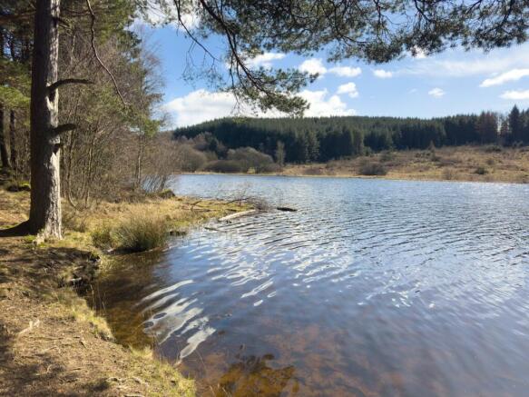
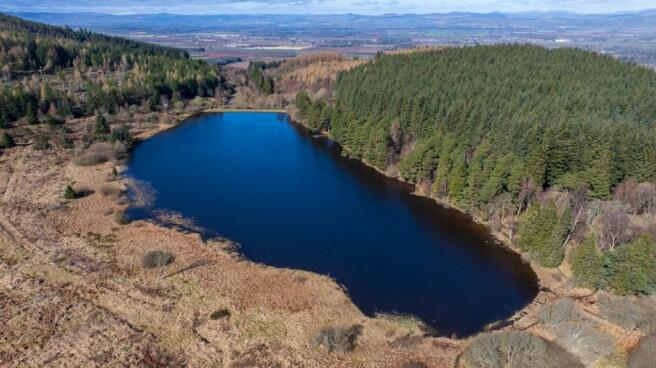
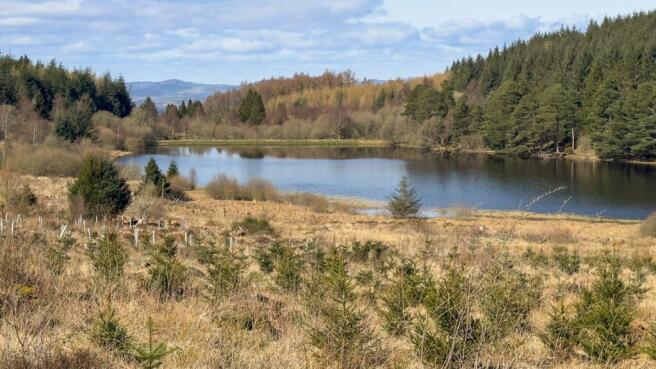
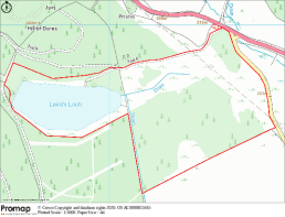
The subjects of sale form an amenity woodland and Loch, both accessible by foot with car parking at the entrance. There are signs that historically vehicular access may have been possible but this is now largely overgrown. This is clearly a much-enjoyed area of land, formerly known as the Hallyburton Estate Community Woodland, we understand Woodland Grant Schemes were carried out between 1991 and 2002 across the land and its peripheries. There are some beautiful viewpoints, picnic areas, woodland and Lochside walks and immediate access to the adjacent woodland walk at North Ballo Hill. The lochs have been occupied in recent years by commercial tenants, offering fishing for coarse fish then more recently for stocked trout. Its variable depth, weed cover, and lack of algae make it a very suitable habitat for fishing. The loch is registered under the Reservoirs Act and holds a SSSI designation. Laird’s Loch was notified as a Site of Special Scientific Interest on the basis of its open water, aquatic plant communities and extensive fringing acidic mires. Laird’s Loch is naturally mesotrophic and lies in a shallow, flat basin. It is evidenced from reports that the bottom of the loch is mud and silt, lying over gravel and stones and that the loch is largely between 1 and 2 metres deep but is dammed and deeper at its western end. We understand that it is drained by a small stream. The loch is notable for the number of pondweed species. The acidic mires fringing the loch are the most extensive of their type in the Sidlaw Hills. The path linking the woodland to the path network around North Ballo Hill to the southwest of Laird’s Loch runs along the north side of the loch within a few feet of the shoreline.
There is a structure by the Lochside, which we assume to have been a boathouse which is now in very poor repair. There are no services available.
The sellers have declared that the amenity woodland is of a mixed age comprising of mainly native conifers and broadleaves.
Location
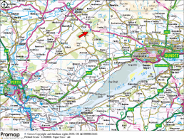
This idyllic land parcel is located approximately 4.2 miles south east of Coupar Angus. Coupar Angus is a popular town within commuting distance of the larger centres of Dundee and Perth. The town is well places for access to A90 some 15 miles to the east which links Dundee and Aberdeen. There is an established parking bay at the entrance to the woodland where a number of paths have been established around North Ballo Hill and Lairds Loch.
ENVIRONMENTAL DESIGNATIONS
We understand that the area is approved for Species Conservation under FGS. It is about reducing deer impact to allow regeneration, controlling grey squirrels to help the red population and controlling pests for Capercaillie and Black Grouse.
The area has FGS Eligibility as a Grey Squirrel Control area. The aim of this option is to support the targeted control of grey squirrels in areas where they are a threat to red squirrel populations. This support is offered via the Forestry Grant Scheme - SMF - Species Conservation - Grey Squirrel Control
In addition the area is recognised as FGS Eligibility Native Woodland Habitat Network and approved for fencelines and native woodland surveys.
There is a prehistoric Scheduled Ancient Monument (Hill Fort) within proximity to the subjects of sale, previously cleared of trees to the north of the Loch. Reference: Hill of Dores, SM7315.
THIRD PARTY RIGHTS AND SERVITUDES
The land is affected by overhead lines for which we assume servitudes are in place. The car park will be included within the sale with unrestricted access rights over retained by the seller, to allow access to their lands to the North West (the car park is hatched in red on the attached sales plan). The land to the south is owned by Forest and land Scotland who hold servitude rights of access over the subjects of sale. The subjects are sold together with and subject to all existing rights of way, servitudes, wayleaves and others whether contained in the Title Deeds or otherwise, and purchasers will be deemed as satisfied themselves in respect thereof.
Brochures
Lairds Loch, Coupar Angus, Blairgowrie, PH13 9LA

NEAREST STATIONS
Distances are straight line measurements from the centre of the postcode- Invergowrie Station6.7 miles
Notes
Disclaimer - Property reference 362076-1. The information displayed about this property comprises a property advertisement. Rightmove.co.uk makes no warranty as to the accuracy or completeness of the advertisement or any linked or associated information, and Rightmove has no control over the content. This property advertisement does not constitute property particulars. The information is provided and maintained by DM Hall, Bridge of Allan. Please contact the selling agent or developer directly to obtain any information which may be available under the terms of The Energy Performance of Buildings (Certificates and Inspections) (England and Wales) Regulations 2007 or the Home Report if in relation to a residential property in Scotland.