
Pill Road, Abbots Leigh, Bristol, Somerset, BS8
- PROPERTY TYPE
Detached
- BEDROOMS
3
- BATHROOMS
2
- SIZE
Ask agent
- TENUREDescribes how you own a property. There are different types of tenure - freehold, leasehold, and commonhold.Read more about tenure in our glossary page.
Freehold
Key features
- Versatile smallholding
- 3 bedroom detached house
- Range of modern agricultural buildings
- Ring-fence productive pastureland extending to 18.92 acres in total
- Situated on the outer fringes of the city of Bristol
Description
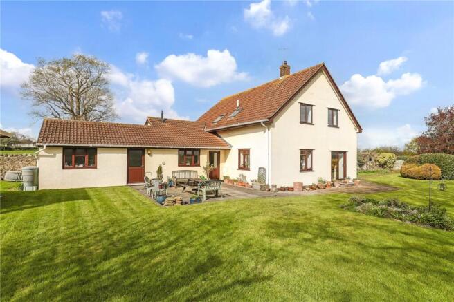
Blackmoor Lodge was previously run as a smallholding, where the current vendors reared cattle for a number of years. Farming has since ceased at the holding and has more recently been used for equestrian livery, with the land being let for the grazing of horses. The property presents an opportunity to acquire an excellent smallholding in the sought after area of Abbots Leigh on the outer fringes of the city of Bristol.
The main residence is a detached three bedroom property, which offers spacious accommodation in good condition throughout, but would benefit from an element of modernisation to part. Adjacent is a range of modern agricultural buildings, which have been adapted for equestrian purposes in recent years. Immediately surrounding the property is a ring-fence block of productive pastureland the whole of the property being set in 18.92 acres (7.65 hectares) or thereabouts.
The property is being offered for sale by Private Treaty as a whole.
SITUATION
Blackmoor Lodge is situated on the outer fringes of the city of Bristol. The property has excellent links to Pill Road leading into Martcombe Road, which is a short distance from junction 19 of the M5 motorway, offering excellent links to the surrounding road network. Ashton Gate Stadium is located only 3.5 miles to the east of the property, being approximately an 8 minute drive. The centre of the city of Bristol is approximately 5 miles to the east, being around a 25 minute drive via Clifton Suspension Bridge. The city of Bristol offers excellent facilities to include bars, clubs and Ashton Gate Stadium. Bristol also offers a number of private schools to include Clifton College and Bristol Grammar. Bristol Temple Meads is 5.8 miles distant, providing excellent rail links to London Paddington. Bristol International Airport is situated 9.6 miles from the property and provides a number of outbound flights to many popular destinations.
DESCRIPTION
Blackmoor Lodge offers a rare opportunity to acquire a versatile smallholding on the outer fringes of the city of Bristol. Boasting an array of useful agricultural buildings and productive pasture land, Blackmoor Lodge is well suited to a small farming enterprise, amenity uses or equestrian use, subject to any necessary statutory consents.
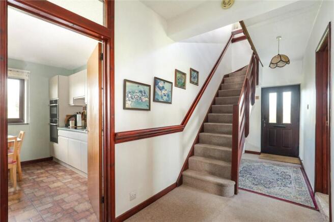
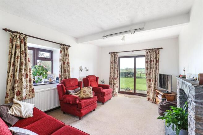
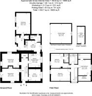
The main residence comprises a detached property which has been extended over the years by the current vendors. The property has been well cared for by the current vendors, but would benefit from a degree of modernisation throughout in due course affording potential purchasers an opportunity to enhance the property to their liking. The accommodation is available over two floors and is more particularly described as follows: -
On the ground floor
Entrance Door leads to hallway with storage cupboard, stairs to first floor and door to Sitting Room with fireplace and sliding door to outside, Dining Room, Study and Kitchen with range of fitted floor and wall units, sink unit, electric hob and eye level built-in oven, door to Utility Room with sink unit and cupboards. Door giving access to Ground Floor Shower Room with WC, wash basin, shower cubicle and part tiled walls. Rear Hallway with cupboard housing the boiler, door to outside and door to Workshop.
On the First Floor
Bedroom 1 with walk-in wardrobe, Bedroom 2 with En-Suite Shower Room comprising WC, pedestal wash basin and shower cubicle, Bedroom 3, Family Bathroom with WC, pedestal wash basin and bath with shower over.
For full details of measurements please refer to the floor plan.
Agricultural Buildings
Situated immediately north of the residence is a large range of modern and part traditional buildings. The current owners have previously used the buildings for agricultural and livestock purposes and more latterly have used the buildings for equestrian purposes and have been used for livery. A number of the buildings are of modern construction which are in excellent condition throughout and will offer prospective purchasers an opportunity to carry out a wide range of uses, subject to obtaining the necessary statutory consents. The buildings can be more particularly describes as follows, which corresponds with the building plan: -
Building 1:- 6.22m x 7.94m. Timber frame with corrugated tin roof and sides. Part concrete block walls, double wooden doors to front, housing a bunded oil and diesel tank.
Building 2:- 17.56m x 6.26m. Steel portal frame building under fibre cement sheeted roof with Perspex roof lights, box profile tin sheets to part and concrete block walls to part with the remainder open, concrete floor, one part of this building has been converted into a stable which measures 3.29m x 4.29m.
Building 3:- 6.22m x 8.73m. Lean-to off building 2, comprising timber frame under box profile tin roof, traditional stone wall to part, concrete floor and internal stable measuring 3.64m x 3.08m.
Building 4: - 13.77m x 8.83m. Steel portal frame building under fibre cement sheeted roof with Perspex roof lights, concrete block walls to part, concrete floor and fibre cement sheets to one side.
Building 5:- Timber building under felted roof.
Building 6:- 9.96m x 8.99m. Steel portal frame building under asbestos sheeted roof with Perspex roof lights, box profile tin sheeted wall to one side with Yorkshire boarding to part. Concrete floor to part.
Building 7:- 4.42m x 5.51m. Mono-pitched building of timber framed construction with concrete floor, yard area and concrete block walls to part.
Buildings 8 & 9: - 3.04m x 3.18m plus 3.68m x 3.42m. Cantilever to the front, concrete block walls with concrete floor.
Building 10:- 3.72m x 3.21m (gross external area). Timber mono-pitched tack room.
Building 11:- Comprising timber stables under asbestos roof with concrete block walls and concrete floor. Comprising 3 stables—Stable 1 3.38m x 3.72m, Stable 2 3.41m x 3.10m and Stable 3 3.05m x 3.41m.
Building 12:- 2.67m x 4.88m. Lean-to off building 1. Metal tin sheet roof and sides.
Building 13:- 5.26m x 12.01m. Mono-pitched building with traditional walls to part, concrete panel walls to part, box profile sheeted roof.
Building 14:- 1.64m x 2.06m. Red brick building under box profile tin roof with concrete floor.
Building 15:- 5.25m x 5.26m. Concrete block walls, timber trusses with concrete floor, double roman tiled roof and window.
Buildings 16 & 17:- 5.64m x 3.34m and 1.51m x 2.64m. Workshop building with concrete box profile tin roof and sides with concrete floor.
The Land
The land comprises a ring-fence block of agricultural pasture land which extends in total to 17.94 acres (7.26 hectares). The land is level in gradient and is bordered by well maintained boundary hedgerows. Part of the land to the north, being parcel 4099 has been planted as a woodland over the years and is now becoming established as a woodland, which offers an additional feature to the land. The land is productive permanent pasture, which is classified as Grade II under the DEFRA Land Classification Map and comprises slightly acid loamy and clayey soils with impeded drainage. The access to the land leads from the principal access into the holding, which leads to Pill Road to the west. The land is well maintained and is bordered by excellent boundary hedgerows.
SERVICES
Mains electric, water, drainage and oil fired central heating is connected.
OUTGOINGS
North Somerset Council Tax Band ‘F’.
DIRECTIONS
From Junction 19 of the M5 motorway, proceed and take the exit signposted Easton In Gordano and proceed along Martcombe Road . After approximately 2 miles turn left and then left again into Pill Road. After passing 4 properties on the right hand side take the track to the right hand side. Continue bearing right at the bend in the track and then the property will be in front of you.
METHOD OF SALE
The property will be offered for sale by Private Treaty as a whole.
CONSUMER PROTECTION REGULATIONS
While we endeavour to make our sales details accurate and reliable, if there is any point which is of particular interest to you please contact the office and we will be pleased to confirm the position for you, particularly if you are contemplating travelling some distance to view the property.
TENURE AND POSSESSION
The property is of a freehold tenure with vacant possession available on completion.
STATUTORY DESIGNATIONS
The property is situated in a SSSI Impact Risk Zone—for LPAs to determine likely impacts on SSSIs and when to consult Natural England. The property is located in the Bristol and Bath Green Belt and National Character Area of Bristol.
TOWN AND COUNTRY PLANNING
The land, notwithstanding any description contained in these particulars is sold subject to any Development Plan, Tree Preservation Order, Town Planning Schedule, Resolution or Notice which may be or which may come to be in force, and also subject to any statutory provision of byelaws without any obligation on the part of the Vendors to specify them and the Purchaser shall be deemed to have full knowledge of and to satisfy themselves about the provisions of any such matter affecting the property.
We understand that an oak tree near to the entrance of the property is subject to a Tree Preservation Order (TPO).
DEVELOPMENT CLAWBACK
The agricultural land will be sold subject to a development clawback of 33.33% of any change of use other than agricultural or equestrian for a period of 25 years.
HEALTH AND SAFETY
Our Health and Safety policy requires that all interested parties undertaking viewings, if accompanied by a member of GTH staff, must wear their own Personal Protective Equipment (PPE). If interested parties do not adhere to our policy and view the property unaccompanied (or without PPE) then they do so at their own risk, and we/the seller cannot be held liable for any personal injury or claim for compensation.
There are unsafe buildings at the property and trip hazards, a detailed Health and Safety Risk Assessment is available from the selling agents and must be reviewed prior to any viewing. Therefore, please contact the agent to arrange a viewing of the property.
RIGHTS OF WAY
There are public footpaths which cross the land, as indicated by the dashed line on the site plan. The footpath reference number is NS|LA1|6/20.
The property known as Woodside has the benefit of a right of way access over the main access leading to the property. Contributions have been received towards the maintenance of the track in the past.
WHAT.3.WORDS
For the exact location download the app and enter; ///desire.await.mute
SUBSIDIES AND GRANTS
The land is not subject to any existing land management based schemes including any Sustainable Farming Incentive or Countryside Stewardship Agreements.
VAT
We are not aware that an option to tax has taken place on the property.
WAYLEAVES AND EASEMENTS
The property is sold and so far as required by the Vendors will be conveyed subject to all easements, quasi-easements, privileges and advantages (whether way of water, drainage, light or laying and maintaining water and other pipes or mains of any nature whatsoever) for the benefit of any other property as the owner, tenants or occupiers thereof now or have been accustomed to use, enjoy or exercise. The property is sold subject to all easements and wayleaves of telegraph and telephone poles and stays and wires, and electric pylons, pipes (whether poles and cables, water, gas and other referred to in these Particulars or not) at present erected on and passing over or under the property, and subject to the Agreements affecting the same (if any) and to the Town and Country Planning Scheme, or County, Local Authority or any other statutory body affecting the same.
SPORTING AND MINERAL RIGHTS
The sporting rights and mineral rights are in hand and are included as part of the freehold sale.
LOCAL AUTHORITY
North Somerset Council, Town Hall, Walliscote Grove Road, Weston-super-Mare, North Somerset, BS23 1UJ.
Telephone
FLOODING
The property is situated in a LOW flood risk area.
AGENTS NOTE
The buildings will not be fully cleared and there will also be a number of old machinery items which are stored on the land, to include steel and wooden poles which will remain on the property upon completion and the purchaser will be acquiring the property with these items in situ.
We have been informed by the current vendors that landfill was believed to take place on part of the land in the 1920s, but there is no knowing what was buried at the time.
LAND REGISTRY
The property is currently held under paper deeds. However, a voluntary first registration has been lodged with the Land Registry and an application to expedite has been submitted in order to finalise the Registration.
ADDITIONAL INFORMATION
Broadband: Ultrafast broadband is available—highest available download speed 1000 Mbps.
Mobile Coverage: Available via EE, O2, THREE and VODAFONE. For an indication of specific speeds and supply or coverage in the area we recommend contacting your own provider.
Brochures
Particulars- COUNCIL TAXA payment made to your local authority in order to pay for local services like schools, libraries, and refuse collection. The amount you pay depends on the value of the property.Read more about council Tax in our glossary page.
- Band: F
- PARKINGDetails of how and where vehicles can be parked, and any associated costs.Read more about parking in our glossary page.
- Ask agent
- GARDENA property has access to an outdoor space, which could be private or shared.
- Yes
- ACCESSIBILITYHow a property has been adapted to meet the needs of vulnerable or disabled individuals.Read more about accessibility in our glossary page.
- Ask agent
Pill Road, Abbots Leigh, Bristol, Somerset, BS8

Add an important place to see how long it'd take to get there from our property listings.
__mins driving to your place
Affordability
About Greenslade Taylor Hunt, Redhill
Unit 6, 8, 9 The Pound, Redhill, BS40 5TZ
Get an instant, personalised result:
- Show sellers you’re serious
- Secure viewings faster with agents
- No impact on your credit score
Notes
Staying secure when looking for property
Ensure you're up to date with our latest advice on how to avoid fraud or scams when looking for property online.
Visit our security centre to find out moreDisclaimer - Property reference BST260063. The information displayed about this property comprises a property advertisement. Rightmove.co.uk makes no warranty as to the accuracy or completeness of the advertisement or any linked or associated information, and Rightmove has no control over the content. This property advertisement does not constitute property particulars. The information is provided and maintained by Greenslade Taylor Hunt, Redhill. Please contact the selling agent or developer directly to obtain any information which may be available under the terms of The Energy Performance of Buildings (Certificates and Inspections) (England and Wales) Regulations 2007 or the Home Report if in relation to a residential property in Scotland.
*This is the average speed from the provider with the fastest broadband package available at this postcode. The average speed displayed is based on the download speeds of at least 50% of customers at peak time (8pm to 10pm). Fibre/cable services at the postcode are subject to availability and may differ between properties within a postcode. Speeds can be affected by a range of technical and environmental factors. The speed at the property may be lower than that listed above. You can check the estimated speed and confirm availability to a property prior to purchasing on the broadband provider's website. Providers may increase charges. The information is provided and maintained by Decision Technologies Limited. **This is indicative only and based on a 2-person household with multiple devices and simultaneous usage. Broadband performance is affected by multiple factors including number of occupants and devices, simultaneous usage, router range etc. For more information speak to your broadband provider.