The Whole - Hawkley Road, GU33
- PROPERTY TYPE
Land
- SIZE
530,996 sq ft
49,331 sq m
Key features
- SEE AND PRINT PDF SALES PARTICULARS AVAILABLE BELOW
- SEE DRONE VIDEO FOOTAGE ON THE VIRTUAL TOUR TAB
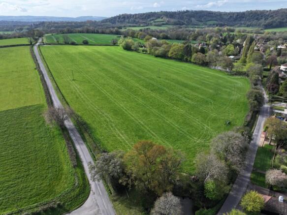
- APPROX. 12.19 ACRES OF ATTRACTIVE LEVEL PASTURELAND
- AVAILABLE AS A WHOLE OR IN TWO LOTS
- EACH LOT BENEFITTING SEPARATE DIRECT ACCESS AND ROAD FRONTAGE
- MAINS WATER CONNECTED
- WELL SUITED TO AGRICULTURAL, EQUESTRIAN, GRAZING, AMENITY, CONSERVATION OR RECREATIONAL USES, SUBJECT TO NECESSARY PLANNING
- WITHIN THE SOUTH DOWNS NATIONAL PARK
- ADJOINING RESIDENTIAL EDGE OF HAWKLEY VILLAGE
- GOOD ACCESSIBILITY TO PETERSFIELD, GUILDFORD AND THE WIDER SOUTHEAST
Description
What3Words:Northern Access (Lot 1): Listed.years.basics; Southern Access (Lot 2): helpfully.sunbeam.stand
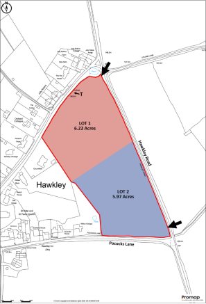
DIRECTIONS: From Hawkley village centre, proceed east along Pococks Lane. The land will be found on the left-hand side and also fronts Hawkley Road to the east. The property benefits from two separate gated access points from Hawkley Road, positioned at the northern and southern ends of the holding, as identified by arrows on the Site Plan. Please refer to the Location Plan and What3Words referenced above.
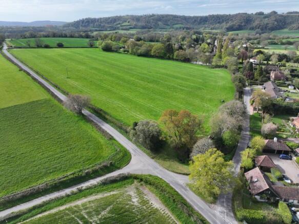
DESCRIPTION: The property comprises an attractive and accessible block of permanent pasture, extending to approximately 12.19 acres (4.93 hectares) in total, positioned on the edge of the sought-after South Downs village of Hawkley. The land is generally level and has historically been used for grazing and hay production. The holding is well suited to agricultural, equestrian, grazing, amenity, conservation and recreational uses, subject to any necessary consents. The property benefits from mains water connected to a trough positioned approximately at the point marked "T" on the Site Plan. The land is offered for sale as a Whole or in Two Lots, as shown on the Site Plan. Each proposed Lot benefits from its own independent roadside access from Hawkley Road, providing flexibility for purchasers and practical day-to-day management. A particularly attractive feature is the village pond situated immediately to the north of the property, complete with seating area overlooking the pond; although the pond itself is not included within the sale.
THE LAND: The land comprises a broadly level parcel of pasture. The pasture is considered suitable for grazing, mowing and general agricultural or equestrian use. The Agricultural Land Classification identifies the land as predominantly Grade 3 agricultural land, comprising freely draining slightly acid loamy soils.
LOTTING: The property is available as a Whole or in two Lots as identified on the Site Plan.
LOT 1 - Approx. 6.22 acres (2.52 ha) of level pastureland with mains water connected and separate roadside access from Hawkley Road (northern access).
LOT 2 - Approx. 5.97 acres (2.42 ha) of level pastureland with separate roadside access from Hawkley Road (southern access).
FENCING - IF SOLD IN LOTS: If the property is sold in two Lots, the Purchaser of Lot 1 will be responsible at their own cost for erecting and thereafter maintaining a stock-proof fence along the new internal boundary separating Lots 1 and 2, within 3 months of completion.
ACCESS & RIGHTS OF WAY: The property benefits from two separate direct access points from Hawkley Road, one situated at the northern end of the property and the other at the southern end, as shown by arrows on the Site Plan. There are no public rights of way crossing the property.
PLANNING: The property lies within the South Downs National Park and falls outside defined settlement boundaries, where countryside planning policies apply. The land may offer longer-term strategic or amenity appeal, due to its position adjoining the village edge, however, purchasers must rely upon their own enquiries in relation to any future planning prospects. The Selling Agents are not aware of any recent planning applications relating to the property.
SERVICES: Mains water is connected to the land. A water trough is situated at the approximate position marked "T" on the Site Plan. No mains electricity is connected.
DESIGNATIONS:
Within the South Downs National Park
Within the Wealden Greensand National Character Area
Adjoins the Hawkley Upper Green Conservation Area to the north
Within Habitat Regulations Assessment Buffer SD10: Wealden Heaths Phase II SPA (5km buffer).
The Selling Agents are not aware of any other significant environmental designations affecting the property.
DEVELOPMENT OVERAGE: Subject to the level of any offers received, the Vendor is mindful
to retain a 25% share of any uplift in value caused by Planning Consent for any residential development on the Property for a period of 25 years.
LAND REGISTRY: The property forms the entirety of Land Registry Title No. HP568807. Copies of Title are available on Selling Agents Website.
BUSINESS RATES: Not currently demanded or assessed.
LOCAL AUTHORITY: East Hampshire District Council, Penns Place, Petersfield, Hampshire, GU31 4EX.
PLANNING AUTHORITY: South Downs National Park Authority, South Downs Centre, North Street, Midhurst, West Sussex, GU29 9DH.
Brochures
Sales ParticularsThe Whole - Hawkley Road, GU33

NEAREST STATIONS
Distances are straight line measurements from the centre of the postcode- Liss Station2.0 miles
- Petersfield Station3.5 miles
About Giles Wheeler-Bennett, Southampton
West Court, Lower Basingwell Street, Bishop's Waltham, SO32 1AJ
Notes
Disclaimer - Property reference HawkleyWhole. The information displayed about this property comprises a property advertisement. Rightmove.co.uk makes no warranty as to the accuracy or completeness of the advertisement or any linked or associated information, and Rightmove has no control over the content. This property advertisement does not constitute property particulars. The information is provided and maintained by Giles Wheeler-Bennett, Southampton. Please contact the selling agent or developer directly to obtain any information which may be available under the terms of The Energy Performance of Buildings (Certificates and Inspections) (England and Wales) Regulations 2007 or the Home Report if in relation to a residential property in Scotland.