
Compiegne Way, Bury St Edmunds, Suffolk, IP33

- PROPERTY TYPE
Land
- SIZE
3,398 sq ft
316 sq m
Description
DESCRIPTION
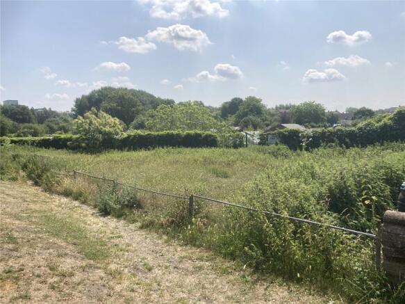
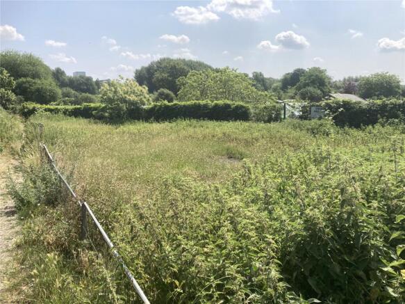
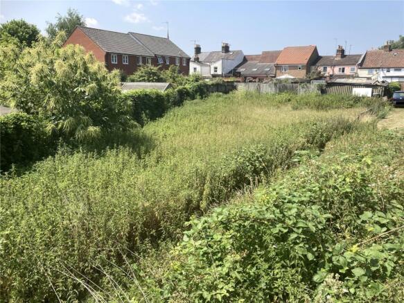
Parcel of land extending to approx. 0.078 acres (316sqm) subject to survey. The land is currently overgrown with vegetation. To the north of the land is Compiegne Way. To the south there are allotments and to the west there are residential dwellings.
LOCATION
The land is located off Compiegne Way approx. 0.6 miles south west of Bury St Edmunds Town Centre. Bury St Edmunds benefits from extensive shopping and leisure facilities, numerous high-quality restaurants and cultural amenities including the Georgian Theatre Royal and the Abbey Gardens. The land also has good access to the A14, A11 (M11) and the railway station at Bury St Edmunds offers a link to mainline services to London Liverpool Street and Kings Cross.
TENURE & POSSESSION
Freehold with vacant possession.
SERVICES
No detailed investigations have been made into the provision of services. Any prospective purchasers must rely on their own enquires in respect of proximity and capacity of services.
ACCESS
We have obtained a Highway record plan from Suffolk County Council. It appears the property abuts the extent of the highway maintainable at public expense. There appears to be an informal footpath along the front of the site.
METHOD OF SALE
The property is available by Private Treaty. The Vendors reserve the right to invite best offers.
OVERAGE
The Land will be subject to Overage. If the Buyer or subsequent owners obtains any planning permissions or permitted development rights for residential or commercial development during the next 30 years, 33% of the uplift in value will be payable to the Seller. Overage will become due on the earlier of disposal with the benefit of qualifying planning permission or commencement of the qualifying permission.
LOCAL AUTHORITY
West Suffolk Council.
West Suffolk House, Western Way, Bury St Edmunds, Suffolk IP33 3YU. Tel:
PLANNING
According to the adopted West Suffolk Local Plan interactive map a small area on the western side of the site is within the settlement boundary. All interested parties should make their own enquiries with the Local Planning Authority.
FLOOD RISK
According to the GOV.UK Flood Risk Maps the land is within a low to medium chance of flooding from Rivers and sea. The land is also within a mid to high chance of surface water flooding.
DIRECTIONS
Exiting the A14 at junction 43 from the Stowmarket direction at the roundabout take the first exit onto Compiegne Way. After 0.2 miles the land is located on your lefthand side identified by a Lacy Scott & Knight ‘For Sale' board.
what3words: ///snowboard.superhero.patching
AGENT’S NOTE
Property Particulars prepared April 2026.
VIEWING AND FURTHER INORMATION
During daylight hours with these particulars in hand. For further information please contact: Lacy Scott & Knight: Graham Ford.
N.B. Please be advised the site is overgrown and the ground is uneven. Care should be taken when inspecting the site.
ANTI-MONEY LAUNDERING
Should you wish to proceed with an offer on this property, we are obligated by HMRC to conduct mandatory Anti-Money Laundering Checks. We outsource these checks to our compliance partners at Coadjute and they charge a fee for this service. We are required by law to conduct anti-money laundering checks on all those selling or buying a property as prescribed by the Money Laundering Regulations 2017. Whilst we retain responsibility for ensuring checks and any ongoing monitoring are carried out correctly, the initial checks are carried out on our behalf by Coadjute who will contact you once you have agreed to instruct us in your sale or had an offer accepted on a property you wish to buy. The cost of these checks is £33.00 (incl. VAT), which covers the cost of obtaining relevant data and any manual checks and monitoring which might be required. This fee will need to be paid by you in advance of us publishing your property (in the case of a vendor) or issuing a memorandum of sale (in the case of a buyer), directly to Coadjute, and is non-refundable. Lacy Scott & Knight do not receive any commission for this payment/service.
Brochures
ParticularsCompiegne Way, Bury St Edmunds, Suffolk, IP33

NEAREST STATIONS
Distances are straight line measurements from the centre of the postcode- Bury St. Edmunds Station0.2 miles
- Thurston Station3.9 miles

About Lacy Scott & Knight, Bury St Edmunds
10 Risbygate Street Bury St. Edmunds IP33 3AA


Notes
Disclaimer - Property reference BAL260019. The information displayed about this property comprises a property advertisement. Rightmove.co.uk makes no warranty as to the accuracy or completeness of the advertisement or any linked or associated information, and Rightmove has no control over the content. This property advertisement does not constitute property particulars. The information is provided and maintained by Lacy Scott & Knight, Bury St Edmunds. Please contact the selling agent or developer directly to obtain any information which may be available under the terms of The Energy Performance of Buildings (Certificates and Inspections) (England and Wales) Regulations 2007 or the Home Report if in relation to a residential property in Scotland.