
Land At Cockhagg Allotmentl, Allotment & Plantation, Crook, Kendal, Cumbria
- PROPERTY TYPE
Land
- SIZE
2,506,878 sq ft
232,897 sq m
Key features
- Beautiful amenity woodland and pasture land with spectacular views
- Located within the Lake District National Park (UNESCO World Heritage Site)
- Close to the Villages of Crook and Underbarrow
- Potential for stewardship schemes, biodiversity enhancement, woodland creation and carbon sequestration
- Will appeal to investors, for private amenity and environmental purposes
Description
An exciting opportunity to purchase a block of woodland and pasture land extending to 57.55 acres (23.28 hectares).
Likely to appeal to investors, for private amenity and environmental purposes
Situated close to the Villages of Crook, Underbarrow and Crosthwaite,
within the Lake District National Park (UNESCO World Heritage Site).
Particulars
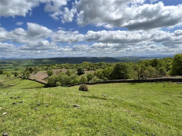
Land extending to approximately 57.55 acres (23.28 hectares) with spectacular views across the Winster and Lyth Valleys to Scout Scar, Morecambe Bay and the Lakeland Fells.
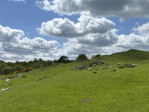
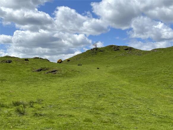
The land is in two parcels. The first field is known as Cockhagg Allotment and is situated directly off the private road leading to Cockhagg. The allotment land consists of permanent pasture with some areas of rocky out-crop. The land is undulating and extends to approximately 20.9 acres (8.46 hectares). There is a public footpath crossing the Allotment from east to west.
The second parcel is known as Cockhagg Plantation and comprises of stunning mixed age native woodland extending to approximately 36.65 acres (14.83 hectares). It has a variety of species including Oak, Birch, Alder, Rowan, Sycamore, Hawthorn and Holly. The woodland has streams running through it and is incredibly picturesque. Amongst the trees, the land has some fantastic habitats, with areas of open pasture and flora including bluebells, heather and much more.
The land is classed under the Agriculture Land Classification Provisions (England) as a mixture of Grade 4 and 5.
The boundaries are dry-stone walls with a deer fence atop the walls around the woodland.
Directions
Coming from Kendal take the B5284 (Crook Road). From the Crook roundabout continue for 2.7 miles, then turn left approximately 0.4 miles after the Sun Inn. Continue for 0.5 miles on an unnamed road, and then turn right onto a single lane tarmac road (sign posted Crook Hall). Cockhagg Allotment is on the left after approximately 0.8 miles.
Please note there is to be no turning or parking on the access road. The photograph shown here displays the access route over the adjoining land [which is separately owned] marked purple on the attached sale plan. Viewing is to be by appointment through the Selling Agent and please see important viewing information overleaf, including 4x4 requirement and parking arrangements.
Location
The land is located at Cockhagg, adjacent to Lord’s Lot. The nearby villages of Crook is located 1.5 miles to the Northwest of the land, Underbarrow is located 2.4 miles to the Southwest and Crosthwaite is 3.7 miles to the South. The Town of Kendal is located 7.4 miles to the West of the land.
Grid Reference: SD4496 9349
What3words: novelists.airports.consults
Services
Tenure
Offered for sale freehold with vacant possession.
Sale Plan
The Sale Plan has been prepared for the convenience of prospective purchasers. They are deemed to be correct with any error, omission or misstatement shall not affect the sale. The purchasers must satisfy themselves with its accuracy.
Services The land has a natural water supply.
Wayleave and Easement
The Property is sold subject to and with the benefit of any existing easements, wayleaves and rights of way. The sale is subject to all the existing rights of way, drainage, light, air support and other easements and quasi- easements and outgoings whether mentioned in these particulars or not.
Boundaries
The ownership and maintenance responsibilities of the boundaries are indicated with the “T” marks on the sale plan. Where no “T” marks are shown, the responsibilities are unknown.
Stewardship Schemes
The land is not currently subject to any Stewardship Schemes, however has previously been in a Woodland Management scheme which has now expired. It is thought the land would be well suited to some of the new schemes available.
Local Authority
Westmorland and Furness Council - .
Planning Authority Lake District National Park Authority
Tel:
Method of Sale
The property is offered for sale by private treaty.
Viewing
Viewing of the land is strictly by appointment.
Please contact the office to arrange a viewing on (option 3) as there is a key code.
Anyone viewing the land does so at their own risk and is politely asked to ensure that gates are securely closed when leaving the land. The access comprises circa 1.40 km of tarmac single track lane to a short 15 metres section of unsurfaced third party land as shown on the labelled photograph
Note: There is no permission to park on the access route and the access route is not suitable for none 4x4’s. No parking on entrance verge but should park on the field. The vendors and selling agents take no responsibility for any damage caused, or incurred to viewers vehicles.
Please note the photographs were taken May 2023.
Brochures
ParticularsLand At Cockhagg Allotmentl, Allotment & Plantation, Crook, Kendal, Cumbria

NEAREST STATIONS
Distances are straight line measurements from the centre of the postcode- Staveley Station3.1 miles
- Burneside Station3.6 miles
- Windermere Station3.9 miles


Notes
Disclaimer - Property reference KEN230052. The information displayed about this property comprises a property advertisement. Rightmove.co.uk makes no warranty as to the accuracy or completeness of the advertisement or any linked or associated information, and Rightmove has no control over the content. This property advertisement does not constitute property particulars. The information is provided and maintained by H&H Land & Estates, Penrith. Please contact the selling agent or developer directly to obtain any information which may be available under the terms of The Energy Performance of Buildings (Certificates and Inspections) (England and Wales) Regulations 2007 or the Home Report if in relation to a residential property in Scotland.