
Onich, Fort William, Inverness-Shire
- PROPERTY TYPE
Country House
- BEDROOMS
3
- SIZE
Ask agent
- TENUREDescribes how you own a property. There are different types of tenure - freehold, leasehold, and commonhold.Read more about tenure in our glossary page.
Ask agent
Description
It extends to approximately 2,388 acres (966 hectares) and comprises two three-bedroom dwellings and a range of traditional estate buildings surrounded by in-bye pasture, rough grazings and open hill. In addition, there are opportunities for sport, development and
recreation as well as natural capital enhancement and ecological restoration.
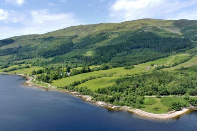
The estate rises from the shores of Loch Leven at approximately 10 metres above sea level on its
southern boundary to the peak of Mam na Gualainn at 796 metres above sea level on its eastern boundary. Other summits include Tom Meadhoin (621 metres), Doire Ban (566 metres) and Creag Bhreac (449 metres). There are impressive views south across Loch Leven towards the top of Glen Coe and the Glen Coe National Nature reserve, north west towards Fort William
and Corpach, and east towards The Mamores.
Several small rocky beaches along the lochside provide direct access to the loch.
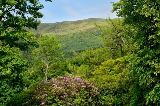
The local area boasts a wide range of wildlife and enthusiasts can observe seals, porpoises, dolphins and many sea birds including Golden Eagles
within a short distance of Callart. Red deer are prevalent in the area but the flora and fauna also attract roe deer, foxes and pine martens.
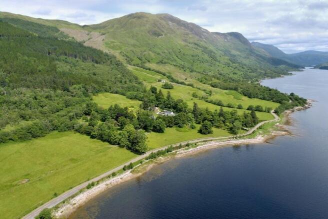
CALLART BUNGALOW
Located to the southern boundary of the estate above the estate buildings, is Callart Bungalow;
a traditional dwelling of stone and slate construction that has been rendered and white-washed. The bungalow has a south-facing
position beside the private farm road above Callart House. It is conveniently located near the estate buildings and is understood to date from 1903.
The cottage is both spacious and comfortable, comprising a conservatory, sitting room, kitchen, hallway, three bedrooms, a bathroom and a rear porch with WC.
The cottage is in good condition and has been both well maintained and modernised. The property benefits from double-glazing, private water and oil central heating. There is mains electricity and private drainage.
Externally, the enclosed garden is predominantly laid to lawn with a raised decking area to the south and a gravel drive and garage to the north.
FANK COTTAGE
Fank Cottage is situated about 300 metres beyond Callart Bungalow and is accessed off the private estate road. It has a south-facing, elevated
position with a spectacular outlook over Loch Leven and towards the twin peaks of Beinn a’ Bheither.
The cottage is of stone construction with a harled and white painted exterior beneath a pitched slate
roof. The accommodation is over a single storey and includes a sitting room, kitchen, bathroom
and three bedrooms.
The cottage is in good condition but would benefit from some cosmetic upgrading and modernisation
throughout. The cottage has mains electricity, a private water supply (via a spring) and private drainage. It has night storage heating and is
double glazed. A back boiler heats the water.
An area of lawn surrounds the cottage and is enclosed by a combination of a post and wire
fence and a dry-stone wall.
The cottage is let on a Short-Assured Tenancy.
AGRICULTURE
Extending to approximately 2,388 acres in total, the land at Callart comprises 87 acres of in-bye
pasture, 34 acres of open native woodland, 212 acres of rough grazing and 2,044 acres of open hill
and moorland.
In terms of land quality, the best ground on the estate is situated on the lower ground along the shores of Loch Leven and surrounding the estate buildings where there are several enclosures of permanent pasture. Moving north, the land rises steeply through areas of rough grazing, with a predominance of native deciduous woodland (an
attractive feature of the estate), bracken and coarse vegetation. This land falls within the Ben Nevis and Glen Coe National Scenic area. Beyond the Forestry and Land Scotland owned Callart Forest, circa one mile to north of the estate
buildings, the remainder of the estate comprises open hill ground that drops down into a northwesterly-facing bowl which extends to the northern boundary along the Allt na Lairige Mòire burn, a short distance from the West Highland
Way. The land is classified by the James Hutton Institute as grade 6, suited best for rough grazing.
The estate previously ran an in-hand flock of approximately 1,300 breeding ewes but these have been sold off in recent years and there are now very few sheep on the estate. We understand that the estate owns basic payment entitlements and
that these will form part of the sale.
There are a small number of estate buildings that were used in connection with the former sheep farming enterprise and deer stalking activities on the estate. These include traditional stone and
slate outbuildings plus a former gardener’s cottage and a bell tower. The buildings comprise a Lochaber-style barn, a workshop, a former
gardener’s cottage and livestock accommodation. All buildings are accessed from the public road
over a private estate road. This first section of this road is shared with Callart House.
SPORTING AND AMENITY
With the majority of the estate comprising rough grazing and hill ground, Callart provides a perfect
setting for any ground sporting enthusiast, with Loch Leven and the Allt na Lairige Mòire burn providing ample opportunity for those that enjoy fishing in the Scottish countryside. The estate owns to the low water mark in Loch Leven and benefits from ownership of the fishing rights.
Current management practice with regard to deer stalking is to undertake culling on a non-commercial basis to both maintain the welfare of the deer herd and for the health of the natural environment. Delivering its sustainable and legal deer management responsibilities, the current owners have carried out condition-selective culls in recent years. The estate has a relatively high red deer density due to its location next to established
commercial woodland; therefore, it has been recommended by the local deer management group (Mid-West Deer Management Group) that the cull numbers be increased over the coming years to target densities of eight deer per square kilometre.
There is currently no larder or carcass storage/chilling facilities at Callart; however, the estate
buildings would provide several options for installing a modern facility.
POTENTIAL DEVELOPMENT OPPORTUNITIES
There are a number of potential development opportunities at Callart including the estate
buildings, a sheep fank located in front of Fank Cottage and a former shepherd’s cottage and
sheep fank at Lairigmor. These sites could provide a purchaser with an opportunity to create additional residential accommodation on the estate subject to obtaining planning permission from The Highland Council.
WOODLAND
There are small areas of native woodland and policy woodland around the estate buildings and
along the shoreline between field enclosures but there is no commercial forestry at Callart.
NATURAL CAPITAL
With the urgent call for action to restore damaged peatlands and rewild landscapes, Callart could
offer possibilities for small scale carbon sequestration although no surveys have been undertaken by the vendors. According to
Scotland’s Peatland map there are areas of class 1, 2, 3 and 5 peatland on the estate.
TELECOMMUNICATIONS MAST
Approximately 800 metres to the north of the bungalow is a telecoms mast. The mast has been on the estate for approximately 20 years and is currently let to Vodafone and a number of smaller operators with a passing rent of £2,500 per annum. We understand that the mast was
upgraded in 2024/25.
Callart Estate occupies a prime position on the northern shore of Loch Leven, just outside the
village of North Ballachulish in the West Highlands. Surrounded by dramatic mountain scenery and native woodland, the estate enjoys exceptional privacy while remaining accessible—just off the
A82 and within easy reach of Fort William (15 miles) and Glencoe (4 miles). The location offers
direct access to some of Scotland’s finest outdoor pursuits, including hillwalking, climbing, skiing and
water sports. Oban and Inverness are both accessible by road, and Glasgow Airport is around two hours’ drive, providing good transport connections.
Loch Leven is a tidal sea loch stretching inland from Loch Linnhe, framed by steep-sided mountains and native woodland. Known for its
outstanding natural beauty, it sits at the heart of the West Highlands and is particularly admired for the views towards Glencoe and the Mamores. The loch is popular for kayaking, wild swimming and small-boat sailing, with abundant wildlife
including otters, seals and sea birds. Quiet and atmospheric, Loch Leven offers a sense of seclusion while being only a short distance from key routes and villages. Loch Linnhe is a long sea loch running southwest from Fort William to the Firth of Lorne, forming a key part of the West Highland coastal landscape. Its broad waters are backed by dramatic mountain scenery and open to the west, offering striking sunsets and expansive views. The loch is navigable and supports local marine activity including sailing, fishing and ferry transport. Its shores are dotted with small
communities, forests and historic sites, contributing to its strong sense of place and natural heritage.
The closest villages are North and South Ballachulish (3 miles west), Ballachulish (6 miles to the south) and Onich (5 miles to the west).
Nearby, the popular ferry port at Corran (8 miles) provides direct access to various peninsulas to the
west, including Ardgour, Morven, and Ardnamurchan. The nearest large town is Fort
William, the largest town in the West Highlands and a key regional hub, positioned at the foot of Ben Nevis and the head of Loch Linnhe. Known as the “Outdoor Capital of the UK”, it offers a full range of services and amenities while sitting in the heart of some of Scotland’s most iconic scenery.
The town has a population of around 10,000 and provides essential facilities including supermarkets, independent shops, schools, a hospital and a railway station with direct links to Glasgow and the scenic West Highland Line. A popular base for climbers, skiers, mountain bikers and walkers, Fort
William is surrounded by renowned trails, including the West Highland Way and the Great Glen Way. The nearby Nevis Range offers year-round
mountain sports, including skiing in winter and a world-class downhill mountain biking track in summer. Loch Linnhe provides opportunities for sailing, kayaking and wildlife watching.
Fort William also hosts a range of cultural and community events, from Highland games to film
festivals. Despite its popularity with tourists, it remains a working town with a strong local character, balancing natural beauty with practical day-to-day living.
The closest of Scotland’s major cities is Glasgow, the most populous city in Scotland, which is located approximately 100 miles to the
southeast. Glasgow has a range of retail, educational, leisure and commerce facilities, together with a mainline railway station and an
international airport with regular flights to European cities and other international destinations.
Brochures
Web DetailsParticulars- COUNCIL TAXA payment made to your local authority in order to pay for local services like schools, libraries, and refuse collection. The amount you pay depends on the value of the property.Read more about council Tax in our glossary page.
- Band: TBC
- PARKINGDetails of how and where vehicles can be parked, and any associated costs.Read more about parking in our glossary page.
- Yes
- GARDENA property has access to an outdoor space, which could be private or shared.
- Yes
- ACCESSIBILITYHow a property has been adapted to meet the needs of vulnerable or disabled individuals.Read more about accessibility in our glossary page.
- Ask agent
Energy performance certificate - ask agent
Onich, Fort William, Inverness-Shire

Add an important place to see how long it'd take to get there from our property listings.
__mins driving to your place
Affordability
Get an instant, personalised result:
- Show sellers you’re serious
- Secure viewings faster with agents
- No impact on your credit score
Notes
Staying secure when looking for property
Ensure you're up to date with our latest advice on how to avoid fraud or scams when looking for property online.
Visit our security centre to find out moreDisclaimer - Property reference EDN170027. The information displayed about this property comprises a property advertisement. Rightmove.co.uk makes no warranty as to the accuracy or completeness of the advertisement or any linked or associated information, and Rightmove has no control over the content. This property advertisement does not constitute property particulars. The information is provided and maintained by Strutt & Parker, Scottish Estates & Farm Agency. Please contact the selling agent or developer directly to obtain any information which may be available under the terms of The Energy Performance of Buildings (Certificates and Inspections) (England and Wales) Regulations 2007 or the Home Report if in relation to a residential property in Scotland.
*This is the average speed from the provider with the fastest broadband package available at this postcode. The average speed displayed is based on the download speeds of at least 50% of customers at peak time (8pm to 10pm). Fibre/cable services at the postcode are subject to availability and may differ between properties within a postcode. Speeds can be affected by a range of technical and environmental factors. The speed at the property may be lower than that listed above. You can check the estimated speed and confirm availability to a property prior to purchasing on the broadband provider's website. Providers may increase charges. The information is provided and maintained by Decision Technologies Limited. **This is indicative only and based on a 2-person household with multiple devices and simultaneous usage. Broadband performance is affected by multiple factors including number of occupants and devices, simultaneous usage, router range etc. For more information speak to your broadband provider.