
Quarry Lane, Snarestone, DE12
- PROPERTY TYPE
Land
- SIZE
1,795,979 sq ft
166,852 sq m
Key features
- Approximately 41.23 acres (16.69 hectares)
- Grade 3 Arable land
- Direct road access
- Freehold with vacant possession upon completion
Description
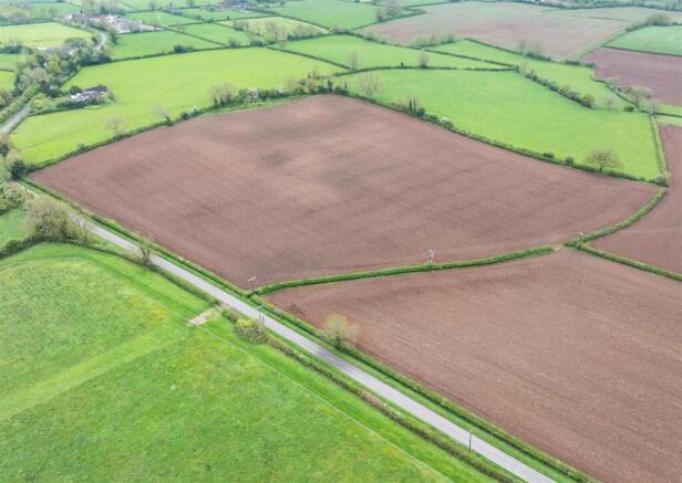
Location - The land is located off Quarry Lane, approximately 0.5 miles to the north of the village of Snarestone. Measham is approximately 2 miles to the northwest and Ashby de la Zouch is approximately 4.5 miles to the north.
The land is well located with convenient access to major transport links with the A444 approximately 3.5 miles to the west and the M42 Junction 11 approximately 4.5 miles to the west.
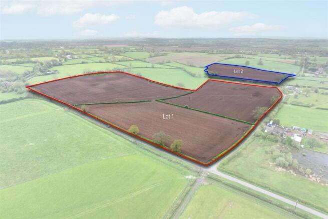
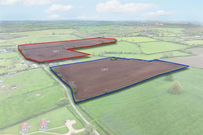
Description - The land is available in two lots as follows:
Lot 1 comprises approximately 29.03 acres (11.75 hectares) of productive arable land, split into three field parcels.
Lot 2 comprises a single parcel of productive arable land, extending to approximately 12.20 acres (4.94 hectares).
The land is classified as Grade 3 on the Agricultural Land Classification Map and according to The Soil Map of England and Wales, the soil is a fine loamy clayey soil of the Flint series.
Lots 1 and 2 both benefit from direct road access off Quarry Lane.
Cropping History - Field Acreage 2023
SK3510 0115 12.20 Maize Winter wheatWinter wheat Maize
SK3510 1342 9.68 Maize Winter wheatWinter wheat Maize
SK3510 2557 6.60 Maize Maize Winter wheat Maize
SK3510 3938 12.75 Maize Maize Winter wheat Maize
Services - We understand that the land benefits from a mains water connection.
Purchasers should make their own enquiries as to the availability and adequacy of services.
Method Of Sale - The land will be sold by private treaty.
Tenure - Freehold with vacant possession on completion.
Holdover - The land is currently in crop and the seller retains the right to harvest this crop in 2026.
Local Authority - North West Leicestershire District Council
Tel:
Easements, Wayleaves And Rights Of Way - There is a public footpath which crosses through the middle of Lot 1, as shown by the green dotted line on the site plan.
There are electricity poles located on the land within Lot 1 and the landowner receives a small annual wayleave payment for these poles.
The land is sold subject to and with the benefit of any easements, wayleaves and rights of way that may exist at the time of sale, whether disclosed or not.
Sporting And Mineral Rights - The sporting rights are to be included in the sale insofar as they are owned. We understand that the mineral rights are not owned and will therefore be excluded from the sale.
Viewing - The land may be viewed during reasonable daylight hours on foot by anyone in possession of a copy of these particulars.
Plan, Area And Description - The plan, area and description are believed to be correct in every way, but no claim will be entertained by the Vendor or their Agents in respect of any error, omissions or misdescriptions.
The plan is for identification purposes only and is not to scale.
Anti-Money Laundering - To enable us to comply with the Money Laundering Regulations we need to verify the buyer’s identity before proceeding with a sale.
We charge a small administration fee for conducting an electronic AML verification check via our online provider, MoveButler.
What3words - Lot 1: ///gravy.trick.spinners
Lot 2: //
ation.model.access
Brochures
Land off Quarry Lane Brochure.pdfBrochureQuarry Lane, Snarestone, DE12

NEAREST STATIONS
Distances are straight line measurements from the centre of the postcode- Polesworth Station6.3 miles


Notes
Disclaimer - Property reference 34681595. The information displayed about this property comprises a property advertisement. Rightmove.co.uk makes no warranty as to the accuracy or completeness of the advertisement or any linked or associated information, and Rightmove has no control over the content. This property advertisement does not constitute property particulars. The information is provided and maintained by Howkins & Harrison LLP, Atherstone. Please contact the selling agent or developer directly to obtain any information which may be available under the terms of The Energy Performance of Buildings (Certificates and Inspections) (England and Wales) Regulations 2007 or the Home Report if in relation to a residential property in Scotland.