Arable Land For Sale by Informal Tender
- SIZE
Ask agent
- SECTOR
Farm land for sale
Description
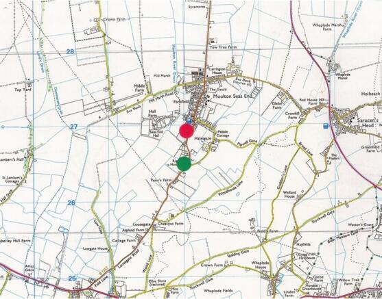
These 2 lots of excellent quality Grade 1 arable silt are situated on the west side of Seas End Road, Moulton Seas End, a short distance south of the village and about 1.5 miles northeast of Moulton. The market towns of Spalding and Holbeach are within easy reach.
LAND GRADE
The land is classified as ´Grade 1´ on the Land Classification Map of England and Wales.
SOIL SERIES
Both parcels are of the Wisbech Soil Series, described as deep, stoneless, calcareous, course silty soils suitable for sugar beet, potatoes, field vegetables, horticultural crops and cereals.
TENURE
The tenure of the land is Freehold.
POSSESSION
Vacant possession will be available at the end of the current tenancy (11th October 2024).
SERVICES
There are no services connected to the land - if any services are required, interested parties should make their own respective enquiries with the relevant service providers as to availability, practicality of connection and costs.
DELINKED PAYMENTS
The outgoing tenant will have the benefit of the delinked payments from the RPA during the years 2024, 2025, 2026 and 2027.
ASSESSMENTS AND OUTGOINGS
Both parcels of land are subject to payment of drainage rates to the South Holland Internal Drainage Board.
Drainage rates payable are provided later in these particulars.
VIEWING
At any time with a copy of these particulars to hand. Those parties entering either field do so entirely at their own risk and should not cause any damage to crops or any other equipment on the land. No responsibility for any injury to persons or anything other will be accepted by the Vendor.
UPLIFT CLAUSE / CLAWBACK PROVISIONS
Should Planning Consent be granted for an alternative use other than agriculture, horticulture or private equestrian, then an uplift payment will be due to the Vendors or their successors in title for a period of 20 years at a rate of 35% of the uplift in value at the then trigger time which will be defined as the earlier of a) implementation of planning consent, b) the commencement of works on site, c) sale of the land with the benefit of such consent or d) the development of the land for alternative uses other than those permitted even though Planning Consent may not have been granted or was required.
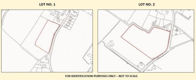
LOT 1
2.639 Acres (1.067) Hectares - Reference no. TF3126/9986 - and fronting onto Seas End Road, Moulton Seas End.
BOUNDARIES
Whilst the farming area has been in two straight lines to the left hand side and to the rear of Lot no.1 the legal (Registered Title) boundaries vary from that. The Registered Title boundaries have been marked with white topped stakes, to indicate the extent of the legal Title.
It will be up to the purchaser of Lot 1, to discuss with the owner of the land to the left and to the rear, if they wish to regularise those boundary lines and deal with the Land Registry accordingly. The offering of Lot 1 is as per the on site marked lines which are clearly visible upon inspection.
BACK CROPPING
2024/25 2023/24 2022/23 2021/20 2020/21 2019/20 2018/19 2017/18
Fallow Greens Wheat Greens Potatoes Greens Greens Greens
DRAINAGE RATES
£45.41 for the 2026/2027 rating year - to be apportioned at completion.
LOT 2
5.27 Acres (2.132) Hectares - Reference no. TF3126/9548 - of land fronting onto Seas End Road, Moulton Seas End.
BACK CROPPING
2024/25 2023/24 2022/23 2021/20 2020/21 2019/20 2018/19 2017/18
Fallow Greens Wheat Potatoes Wheat Greens Greens Greens
DRAINAGE RATES
£101.61 for the 2026/2027 rating year - to be apportioned at completion.
FIXED EQUIPMENT
There is no fixed equipment included in the sale, both Lots are bare land.
DRAINAGE BOARD EASEMENT
It should be noted that some of the boundaries may abut Drainage Board maintained drains which are subject to normal IDB Regulations/bylaws for maintenance, cleansing and repair. Interested parties should make specific enquiry with the South Holland Internal Drainage Board as there will be a 9m wayleave width abutting the drains and no permanent above ground structures are permitted
RIGHTS OF WAY, WAYLEAVES AND EASEMENTS:
The land is offered for sale subject to, and with the benefit, of all existing rights including rights of way whether public or private, light, support, drainage, water and electricity and other rights, easements, quasi-easements, and all wayleaves whether referred to specifically in these Particulars or not.
TENANTRIGHT AND DILAPIDATIONS
There will be no claim made by the outgoing tenant for Tenantright/unexhausted manurial values. There will be no counter-claim allowed for dilapidations on entry (if any).
UNDER-DRAINAGE
We are not aware the land has been under-drained.
CONTRACTS AND QUOTAS
There are no contracts nor quotas available with the sale of the land.
SPORTING AND MINERAL RIGHTS
These are included in the sale of each parcel of land in as far as they are owned by the Vendors.
ENVIRONMENTAL SCHEMES
None of the land has been entered into any Environmental Schemes to date.
PLANS, AREAS AND SCHEDULES
These particulars and plans have been prepared as carefully as possible. It should be noted that the plans have been specifically prepared ´for identification purposes only´ and although believed to be correct, their accuracy is not guaranteed. The land is not registered with HM Land Registry and it will be the responsibility of the purchaser of each Lot to register the land post completion.
Interested parties must carry out such verifications as they may require regarding the extent and resultant areas of each lot. The areas indicated are for ´guidance purposes´ only and may include the area of relevant half dykes which may not necessarily be registered by the Land Registry at the time of first application to have the land registered.
BOUNDARIES
The successful purchaser(s) shall be deemed to have full knowledge of the extent of all boundaries and the land generally.
HOLDOVER
There is no right of holdover being granted to the outgoing Tenant. Both lots are available with the benefit of vacant possession upon completion.
Brochures
Arable Land For Sale by Informal Tender

NEAREST STATIONS
Distances are straight line measurements from the centre of the postcode- Spalding Station5.5 miles
Notes
Disclaimer - Property reference 101505032917. The information displayed about this property comprises a property advertisement. Rightmove.co.uk makes no warranty as to the accuracy or completeness of the advertisement or any linked or associated information, and Rightmove has no control over the content. This property advertisement does not constitute property particulars. The information is provided and maintained by Longstaff Chartered Surveyors, Spalding. Please contact the selling agent or developer directly to obtain any information which may be available under the terms of The Energy Performance of Buildings (Certificates and Inspections) (England and Wales) Regulations 2007 or the Home Report if in relation to a residential property in Scotland.