
Westbury Leigh, Westbury

- PROPERTY TYPE
Land
- SIZE
Ask agent
Key features
- Residential development site with full planning, subject to conditions
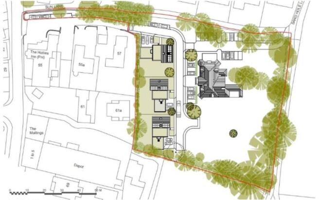
- Consent for three, four bedroom detached properties
- Planning application reference PL/2023/08411
- Set in 0.16 hectares (0.41 acres)
- Close to local amentities
- Tucked away but convenient location
Description
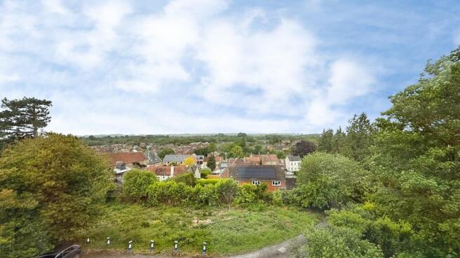
An exciting and rarely available development opportunity situated within the highly sought-after village of Westbury Leigh, on the outskirts of Westbury, enjoying stunning far-reaching countryside views and an attractive semi-rural setting.
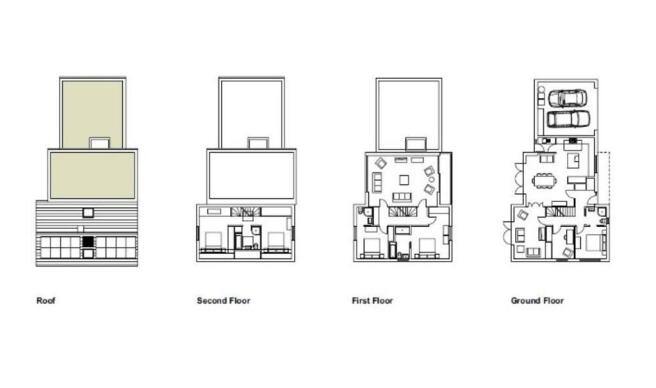
Extending to approximately 0.16 hectares (0.41 acres), the site benefits from full planning permission, granted in April 2024 under application reference PL/2023/08411, for the construction of three substantial detached family homes. Each property has been thoughtfully designed to provide four-bedroom accommodation alongside a one-bedroom annex, private gardens, garage, and off-road parking for multiple vehicles.
The proposed dwellings have been carefully planned to create socially and environmentally sustainable multi-generational homes, ideally suited to modern family living. Flexible accommodation allows for assisted living, independent family space, home working, and domestic business use, while complementing the character and surroundings of this established residential location.
Positioned within an elevated setting, the site is approached via a shared driveway with Courtleigh House.
Offering excellent potential for developers, investors, or self-build purchasers alike, this is a rare opportunity to acquire a well-positioned residential development site with planning already secured for a high-quality scheme in a sought-after Wiltshire village setting.
Further information regarding the approved planning consent and site details is available upon request. Viewings are strictly by prior appointment only.
Property location
Westbury Leigh remains a highly desirable location thanks to its convenient access to local amenities, well-regarded schools, transport links, and nearby countryside walks including routes towards Salisbury Plain and the famous Westbury White Horse. Westbury mainline railway station offers direct services to London Paddington in approximately 80 minutes, while the nearby towns of Trowbridge, Warminster, and the city of Bath are all within easy reach. The A303 and M4 are also conveniently accessible.
How to find me
Satnav postcode: BA13 3TA
What3words:///rising.situated.willpower
For your information
Martin & Co Westbury haven't tested any of the appliances listed in these details, or asked for warranty or service certificates, unless stated - they're on an 'as seen' basis. You should only use floor plans and measurements as a general guide to room layout and design, as they're not exact. Potential buyers are advised to recheck the measurements before completion. Money Laundering Regulations: Purchasers will be asked to produce identification and proof of residency documentation, once an offer has been agreed, we need to hold this on file before solicitors can be instructed.
Westbury Leigh, Westbury

NEAREST STATIONS
Distances are straight line measurements from the centre of the postcode- Dilton Marsh Station0.5 miles
- Westbury Station1.2 miles
- Warminster Station3.0 miles


Notes
Disclaimer - Property reference 100666009659. The information displayed about this property comprises a property advertisement. Rightmove.co.uk makes no warranty as to the accuracy or completeness of the advertisement or any linked or associated information, and Rightmove has no control over the content. This property advertisement does not constitute property particulars. The information is provided and maintained by Martin & Co, Westbury. Please contact the selling agent or developer directly to obtain any information which may be available under the terms of The Energy Performance of Buildings (Certificates and Inspections) (England and Wales) Regulations 2007 or the Home Report if in relation to a residential property in Scotland.