W3W: oval.appointed.answer - Crableck Lane, Sarisbury Green, Southampton

- PROPERTY TYPE
Land
- SIZE
336,283 sq ft
31,242 sq m
Key features
- SEE AND PRINT PDF SALES PARTICULARS AVAILABLE BELOW
- SEE DRONE VIDEO FOOTAGE ON THE VIRTUAL TOUR TAB
- APPROX. 7.72 ACRES IN ALL
- AVAILABLE AS A WHOLE OR IN UP TO 2 LOTS
- CLOSE TO THE BANK OF THE RIVER HAMBLE
- QUIET LOCATION DOWN A SINGLE TRACK LANE
- ADJOINING NEIGHBOURHOOD WOODLAND
- LEVEL, FENCED AND WELL DRAINED
- FIELD SHELTERS
- HISTORICALLY USED FOR STRAWBERRY GROWING
Description
VIDEO DRONE FOOTAGE: See the Selling Agent's website for further details, photographs, drone video footage is available showing the whole Property.
LOCATION: See Location Plan. The Property is shaded red on Location Plans 1 and 2. Postcode SO31 7AL and What3Words: are two gates that serve the land as identified by arrows at Positions A and B on the Site Plan.
DIRECTIONS: From Barnes Lane, at the Sarisbury Green Public Recreation Ground (approx. 100 yards off the A27 main road), turn into Holly Hill Lane signed ‘Universal Marina’ and after approx. 575 yards turn right into Crableck Lane signed ‘ Universal Marina’ and ‘Riverside Social’. Then after approx. 150 yards at the first right hand bend, turn off left to go along the gravel track (effectively straight ahead). This gravel track is a Byway and also called Crableck Lane. Continue along the narrow gravel track for approx. 350 yards and the Property appears straight in front of you at the black gate with Sale Board attached (Gate A). You can park in front of this black Gate A and to the right hand side.
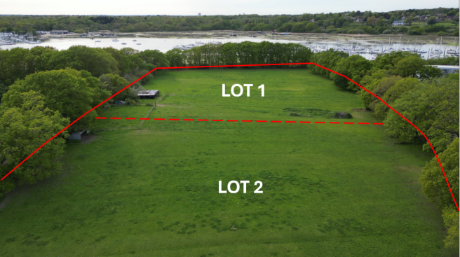
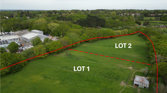
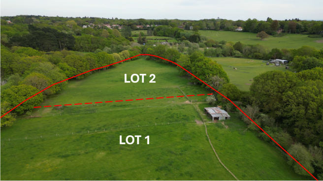
DESCRIPTION: The Property extends in all to approx. 7.72 acres (3.12 Ha) as outlined red on the Site Plan.
A single block of land within the same family ownership for nearly 100 years and used in the past by 3 generations of strawberry growers. The land is positioned in a quiet area and down a narrow lane (Crableck Lane).
The perimeter post and wire fences appear stockproof.
Lotting: There are 3 wooden pegs sprayed yellow on site across the land identifying the potential split between Lot 1 and Lot 2 as identified on the Site Plan. Interested parties can make alternative suggestions for a split if they wish to make an offer.
LAND REGISTRY: The Property comprises the entirety of Titles HP719965 and HP742262 and Land Registry Plans and Registers for each are available on the Selling Agent’s website – Click Here.
The Geological Survey Plan of Great Britain indicates that the subsoils are slowly permeable seasonally wet slightly acid but base-rich loamy and clayey. The Agricultural Land Classification Map indicates the land to be Grade 4. The land lies approx. 5m above sea level.
FIELD SHELTERS: Both Lots 1 and 2 currently have a home made field shelter constructed of wooden pole and tin classing and roof, as identified on the Site Plan and shown by photographs.
ACCESS: LOT 1 – benefits from a right of access over the gravel track shown blue and between Positions A and B on the Site Plan which has been used for many years (40+ years). The western half of this blue route is also covered by a written Easement. There is a vehicular gate at Position B serving Lot 1.
LOT 2 – There is a gate serving the land at Position A on the Site Plan which is at the end of the Byway known as Crableck Lane.
PLANNING: There is no history of any Planning Consents on the Property. The land has been used for grazing purposes for many years and prior to that the growing of strawberries.
DESIGNATIONS: No environmental designations affect the Property.
PUBLIC FOOTPATH: There is a Public Footpath that is parallel to and immediately to the south of the southern boundary fence of the Property. No part of the Footpath route crosses the Property, as identified by the dashed line on the Site Plan. See Selling Agent’s website for extract of Definitive Map which identifies the Footpath by purple line.
BYWAY: Crableck Lane down to Position A on the Site Plan is a Byway Open to All Traffic (BOAT) – a type of public right of way. A BOAT is legally open to: walkers, cyclists, horse riders, horse-drawn vehicles, motor vehicles (cars). See Selling Agent’s website for extract of Definitive Map which identifies the Byway by brown line.
TPO: There is a Tree Preservation Order dated 19th June 2013 which affects the row of 19 Oak Trees and one Larch Tree immediately to the south of the Property (mainly Lot 2). One or two of these trees are within the southern boundary fence. Please see Selling Agent’s website for copy of TPO document with Plan.
SERVICES: None are currently connected to the Property. There is a water main pipe laid in Crableck Lane to the east of the Property. There is a yellow Hydrant sign in the lane approx. 130 yards away from Gate A. Interested parties should make their own enquiries about the availability of connecting to mains water to Southern Water.
DEVELOPMENT OVERAGE: The Vendors are mindful to reserve a share (25%) of any uplift in value of the Property caused by Planning Consent for residential or commercial development over a 50 year period following a sale, but this will not be triggered by the construction of a single dwelling.
LOCAL AUTHORITY: Fareham Borough Council, Civic Offices, Civic Way, Hampshire PO16 7AZ.
Brochures
Sales ParticularsW3W: oval.appointed.answer - Crableck Lane, Sarisbury Green, Southampton

NEAREST STATIONS
Distances are straight line measurements from the centre of the postcode- Bursledon Station0.7 miles
- Hamble Station1.2 miles
- Swanwick Station1.6 miles
About Giles Wheeler-Bennett, Southampton
West Court, Lower Basingwell Street, Bishop's Waltham, SO32 1AJ
Notes
Disclaimer - Property reference CrableckWhole. The information displayed about this property comprises a property advertisement. Rightmove.co.uk makes no warranty as to the accuracy or completeness of the advertisement or any linked or associated information, and Rightmove has no control over the content. This property advertisement does not constitute property particulars. The information is provided and maintained by Giles Wheeler-Bennett, Southampton. Please contact the selling agent or developer directly to obtain any information which may be available under the terms of The Energy Performance of Buildings (Certificates and Inspections) (England and Wales) Regulations 2007 or the Home Report if in relation to a residential property in Scotland.