
Ashley Heath, Ringwood, Dorset, BH24
- PROPERTY TYPE
Land
- SIZE
598,950 sq ft
55,644 sq m
Description
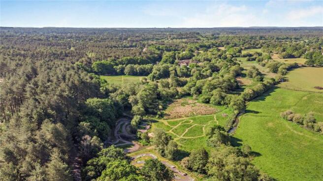
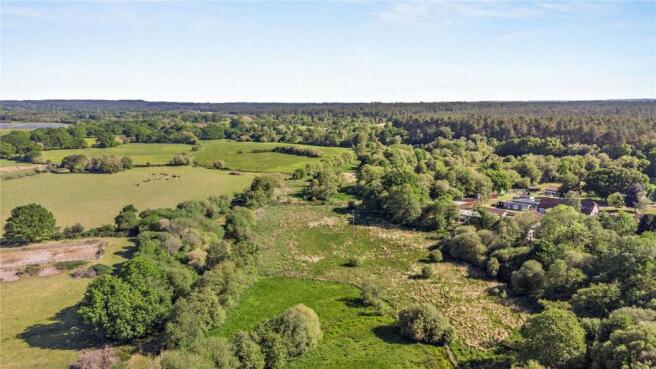
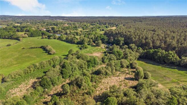
A unique opportunity to acquire a parcel of land let on two Landlord and Tenant 1954 act agreements to Dorset Council with a total rent passing of £8,217.61 p.a. The land includes mixed rough pasture and a children’s 4x4 track run in conjunction with the adjacent Moors Country Park.
In all extending to 13.75 acres (5.56 hectares).
For sale by private treaty as a whole.
Location
Ashley Heath is a small village in Dorset. It lies 2 miles west of Ringwood and 12 miles north east of Bournemouth.
The land is accessed through the entrance to Moors Valley Country Park.
Amenities
Ashley Heath offers the basic range of amenities. The nearby Bournemouth offers a full range of amenities including but not limited to shops, restaurants and petrol stations.
Land
The land comprises 13.75 acres (5.56 ha) of mainly pasture with some shelter belts and small parcels of woodland.
The land is bordered to the west by Moors River and therefore large parts of the land are liable to flooding in the autumn and winter months.
The land currently benefits from a children’s 4x4 track to the north which we understand is a tenant’s fixture.
The land is seen as an investment opportunity but also, subject to obtaining possession, has the potential for agricultural and amenity uses.
Method of Sale
For sale as a whole by private treaty.
Tenure & Possession
The land is for sale subject to the benefit of two Landlord and Tenant 1954 Act agreements to Dorset Council with a total rent passing of £8,217.61 p.a.
More information is available upon request.
Designations
Part of the land sits within the Moors River System Site of Special Scientific Interest.
The land sits within a Site of Special Scientific Interest Impact Zone. Parts of the land sit within Flood Zones 2 and 3.
Services
There are no services to the property that we are aware of.
Wayleaves Easements & Rights of Way
The property is sold subject to the benefit of all rights including rights of way, whether public or private, light, support, drainage, water and electricity supplies and other rights and obligations, easements and proposed wayleaves from masts, pylons, stays, cables, drains, water, gas and other pipes, whether specifically referred to or not.
There are poles across the land for which we assume there are wayleave agreements in place for.
Health & Safety
All viewings are carried out at the sole risk of the viewer and neither the selling agents nor the vendor takes responsibility.
Sporting, Timber & Mineral Rights
The sporting, mineral and timber rights are included in the sale of the freehold in so far as that are owned.
Local Authority
Dorset Council
Viewings
Viewings are unaccompanied but on prior notification to the selling agent.
Parties should note that access is through Moors Valley Country Park and therefore all appropriate parking charges will apply.
Directions
From Ashley Heath, head west on the Horton Road for approximately 0.5 miles. Turn right at the sign to Moors Valley Country Park. Continue straight over the roundabout and through the barriers. Take the next left and continue for 0.1 miles. The entrance gate is on the left.
What Three Words
/// itself.refusals.winks
Brochures
ParticularsAshley Heath, Ringwood, Dorset, BH24

NEAREST STATIONS
Distances are straight line measurements from the centre of the postcode- Christchurch Station8.2 miles

Notes
Disclaimer - Property reference WIR260003. The information displayed about this property comprises a property advertisement. Rightmove.co.uk makes no warranty as to the accuracy or completeness of the advertisement or any linked or associated information, and Rightmove has no control over the content. This property advertisement does not constitute property particulars. The information is provided and maintained by Carter Jonas Rural, Winchester. Please contact the selling agent or developer directly to obtain any information which may be available under the terms of The Energy Performance of Buildings (Certificates and Inspections) (England and Wales) Regulations 2007 or the Home Report if in relation to a residential property in Scotland.