
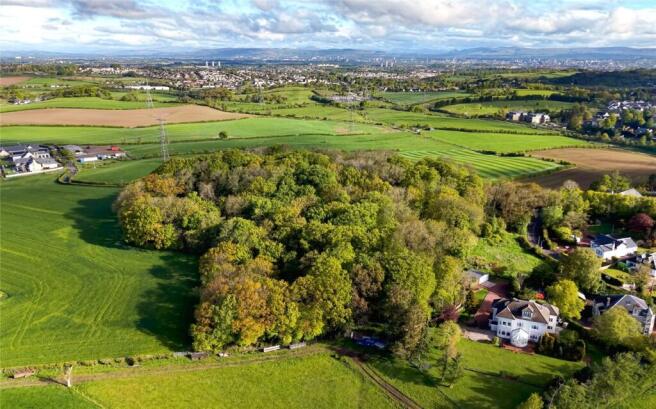
Thorntonhall Woodland, Waterfoot Road, Thorntonhall, South Lanarkshire, G74
- PROPERTY TYPE
Land
- SIZE
299,257 sq ft
27,802 sq m
Key features
- An attractive small mixed woodland in an idyllic peaceful setting.
- Thorntonhall ½ mile East Kilbride 4 miles Glasgow City Centre 9 miles.
- About 6.87 acres (2.78 ha).
- Attractive amenity woodland.
- Mature mix of species.
- Idyllic location.
- Very accessible to Glasgow.
- For sale as a whole.
Description
Calderglen Country Park (about 5 miles) offers riverside walks along the Calder Water, woodland trails, and an ornamental garden. Cathkin Braes Country Park (located about 3 miles north) has a variety of hiking paths and mountain bike trails with panoramic views of Glasgow and the surrounding countryside.
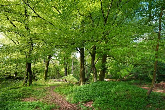
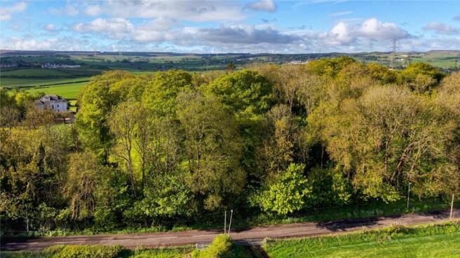
Thorntonhall Woodland comprises a mixed species woodland formerly part of the historic Birkwood House Estate. The woodland extends to about 6.87 acres. The majority of the land at Thorntonhall appears to have been planted approximately 100 years ago. The majority of the planting being amenity broadleaved woodland currently comprising Sycamore, Beech, Oak, and Scots Pine species. The wood benefits from being nearby to the public road network and the site is positioned adjacent to both Peel Road and Waterfoot Road, with remaining boundaries comprising agricultural grazing land. The woodland lies between approximately between 142.8 metres and 156.8 metres above sea level. According to the James Hutton Institute the land is primarily classed as Grade F2 (F2 Land with very good flexibility for the growth and management of tree crops). There is a redundant Lime Kiln on site which was built in 1790. The woodland also provides nesting sights and shelter for birds and other wildlife.
It is important to note areas of the woodland have been subject to windblow and for the avoidance of doubt we would recommend these be cleared to limit associated risks.
Thorntonhall Woodland is offered for sale as a whole.
From Glasgow travel south onto the M77 before exiting at junction 3 signed to Paisley. On leaving the motorway keep right at the traffic lights onto the A727 following the signs to Clarkston and Busby. On leaving the village of Busby, take the 3rd exit on the right at the Peel Roundabout signed Thorntonhall. Travel through the village to the top of the hill before turning right onto Waterfoot Road. The woodland is then on your left.
POST CODE G74 5AD
WHAT3WORDS
To find this property location to within 3 metres, download and use What3Words and enter the following 3 words: //w3w.co/stream.nods.jelly
Brochures
ParticularsThorntonhall Woodland, Waterfoot Road, Thorntonhall, South Lanarkshire, G74

NEAREST STATIONS
Distances are straight line measurements from the centre of the postcode- Thorntonhall Station0.3 miles
- Busby Station1.1 miles
- Clarkston Station1.9 miles


Notes
Disclaimer - Property reference AYR260014. The information displayed about this property comprises a property advertisement. Rightmove.co.uk makes no warranty as to the accuracy or completeness of the advertisement or any linked or associated information, and Rightmove has no control over the content. This property advertisement does not constitute property particulars. The information is provided and maintained by Galbraith, Ayr. Please contact the selling agent or developer directly to obtain any information which may be available under the terms of The Energy Performance of Buildings (Certificates and Inspections) (England and Wales) Regulations 2007 or the Home Report if in relation to a residential property in Scotland.